Leaderboard


Popular Content
Showing content with the highest reputation since 12/17/2012 in all areas
-
Vigilante Trail In 1915, Yellowstone National Park was opened for automobile traffic, and in the first 10 days, 321 cars entered the park; 151 at the west entrance, 86 at the north entrance, 83 at the east entrance and 1 car entered at the south entrance. Vacationers who were traveling from the Pacific Northwest on the Yellowstone Trail could use a cut-off road southeast of Butte, Montana, which was the shortest and most direct route to the west entrance of the park. This cut-off road was also a shorter distance than the main route to Livingston and the north entrance to the park at Gardiner that was promoted by the YTA. To capitalize and to increase the traffic on this cut-off, the commercial interests of Butte organized a meeting on October 22, 1919, where 250 citizens from Silver Bow, Jefferson and Madison counties attended. The result of the meeting was the formation of the Vigilante Trail Association. The route was touted as a road, where almost every mile was the scene of a robbery, murder or hanging. The trail began about 20 miles southeast of Butte at the junction of the Yellowstone Trail, at Cedar Ridge, and ran through the towns of; Twin Bridges, Sheridan, Nevada City, Virginia City, Ennis and terminated at the west entrance to Yellowstone Park. The sign adopted for the route was a circle painted with red, white and blue stripes and included the mystic figures, "3-7-77." which was used by the Vigilantes to warn the criminals that their presence in the country was no longer desirable. Near this junction of the two trails was the reputed spot where Sacagawea was captured by a hostile tribe and had to be rescued from her captors. Years later, she guided Lewis and Clark up the Jefferson River and they passed near the spot where she had been taken. The trail ran on the old Ruby Valley Road through the historic gold mining district, of Alder Gulch and Virginia City. Virginia City is located 7 miles west of Alder Gulch and is one of the oldest settlements in the West. In the 1860s, it was the temporary home for thousands of placer miners. This was a lawless place, where robbery and murder were the order of the day. The Road Agents, as the organized desperadoes were called, had control of the sheriff and the justice of the peace, and the good citizens were left without any protection for their rights, their property or their lives. It all began with the discovery of gold on Grasshopper Creek near Bannack and at Alder Gulch near Virginia City in the spring of 1862. Word of the discovery reached the masses by the summer of 1863, which triggered a stampede of thousands of prospectors rushing to the region. Among the later arrivals were desperadoes and outlaws, who scenting the prey from afar, flew like vultures to the carcass. From the west came a gang of thieves who would become the "Road Agents" and would terrorize and rob people who were traveling between Virginia City and Bannack. Between these two mining camps, a correspondence was kept and the roads throughout the territory were under constant surveillance of the agents. They devised a system that would mark the horses, men and coaches that were worthy of robbing, and that information would be passed to the highwaymen in time before their victims could escape. The road agents, who were also known as the “Innocents,” levied toll on every traveler by robbing and murdering with the greatest impunity. At every turn from Bannack to Virginia City, they held up stages, pack trains and individual miners, killing those who resisted, and beat those who had nothing. So complete their sway, so stern their rule, more than 200 lives were lost along that road. Sheriff Henry Plummer was the chief and everyone knew it. He and some of his men eventually were hung at Bannack in 1864. In 1870, the first chief justice of Montana Territory Hezekiah L. Hosmer had said; "The attraction brought those who came to work and those who came to profit off the labor of others. Had the convicts been set free by the approach of Napoleon, on the condition they burn Moscow, and had instead been thrown upon these new settlements, it could not have been worse than it was with the crowd that entered and took control of Bannack and Virginia City in 1862 and 1863.” If a man brought suit to recover a stolen horse, he would be apt to meet in court with a band of dishonest witnesses who would swear that the contested property belonged to the thief. Thus the man was not only robbed of his property but had to pay the expenses of the suit as well. Gambling and wild women were the main features of every mining camp and these activities were another place for the miners to lose their money. Ladies of the evening plied their trade in the open daylight and the brothels were the lures where many a man was entrapped for robbery and murder. Dance houses sprang up and everyone who visited these establishments were in some way relieved of the money they brought with them. Many good men who dared to show any signs of disgust were shot down by a member of the gang at the first opportunity. The headquarters of these desperadoes was at the Daley ranch otherwise known as the “Robbers’ Roost.” The old inn was located beside the road 4 miles southeast of Sheridan. Of all the villains and criminals who rested at the roost, the most renowned and despised of them all was George Ives, a ruthless servant of the devil. This state of affairs could not go on forever. All of the friends of justice were relentlessly, threatened and watched by the agents. Things began to change when Virginia City and Nevada City formed a Vigilante Committee. The committee was approved and supported by all those who had anything to lose, or who thought their lives were at risk. Merchants, miners, mechanics and professional men alike joined in the movement until, within an incredibly short space of time, the Road Agents were in a state of constant fear George Ives was the first victim of the newly formed vigilante committee. They captured him not far from Robbers’ Roost. Ives was transported to Nevada City where they put him on trial. Ives begged to be taken to Virginia City claiming that the populace of the lower town must, be prejudiced against him, for he had once killed a dog that had bit him while he was there. He was loaded with logging chains, hauled into court and on December 21, 1863, he was hanged. His companions in crime, Red Yager and G. W Brown, the bartender at the Robbers' Roost, were rounded up and hanged within the next two weeks. The Vigilantes, now warmed up to their work, roamed up and down the trail, seeking desperadoes to devour. They traveled south to Bannack where they hanged Sheriff Plummer and his two deputies, Ray and Stilson. They then rode over the pass to Deer Lodge and down to Hellgate, and on their way they hanged a half dozen assorted thieves and highwaymen. In all they executed extreme justice on 32 desperadoes. They left one poor soul dangling from a tree that had the governor’s pardon. They hanged him with all of the official seals and ribbons sticking out of his pants pockets. The Vigilantes soon rid Montana of the Road Agents and were the saviors of Montana. On July 9, 1922, Frank Bell had just returned from a trip to Yellowstone Park and reported that the Vigilante Trail is the best road leading to the park. "The Vigilante Trail is a boulevard all the way," said Mr. Bell "It's no trick at all to leave Butte early in the morning and make the west Yellowstone entrance to the park the same day. That's a jump of about 200 miles, but with the excellent roads it is not a tiresome drive.” “I am sorry to state that the very opposite is true of the Yellowstone Trail. This transcontinental road is in very bad condition, and its main artery, the section on which the Yellowstone Trail association makes its effort to concentrate all travel from Livingston to Gardiner is a disgrace to any trail association and to the counties which are supposed to take care of the trail.” “The road between Livingston and Gardiner is treacherously rough, badly cared for and in many stretches should be resurveyed before it can properly be designated as a road inviting the travel of all the country.” The day Mr. Bell left Butte, he met a tourist who wanted to go to Yellowstone Park via the Yellowstone Trail through Bozeman and Livingston. He had by mistake turned onto the cutoff road for the Vigilante Trail at the top of Cedar ridge. Bell told him he could get to the park that way and it was shorter, but he did not know the condition of the road. They both traveled all the way to West Yellowstone and before they got there, the tourist thanked Bell for putting him on the best road he had traveled for many miles. Today a trip from Butte to West Yellowstone on the modern highway will take you about 2 hours and 24 minutes and a trip from Butte to Gardiner will take you about 2 hours and 28 minutes, a 4 minute difference. Google Map https://www.google.com/maps/d/edit?mid=16FNHbdE1MEM2B_P9_ZevlrGu0mIsbcOj&usp=sharing2 points
-
Midway Park was once a campground which included an old Signal gas station. The park was located on top of Easton Hill about 12 miles east of Snoqualmie Pass and about 5 miles west of Easton. This is where the old 1915 highway diverged from the 1927 highway. Once automobiles could make it over the pass without refueling, the need for this gas station faded. It is unknown when it was first established, although it is said that the building was still there in 1952. Happy Trails Curt2 points
-
Hi Becky, No problem on the delay…… It is kind of you to reply!! I have plenty to keep me out of trouble in any event. BTW, our old friend Denny Gibson was in the Puget Sound area a couple of weeks ago, and we had a great time recalling our Forum adventures. I’ll keep an eye out for any replies to my Forum inquiry. I celebrated my 81st in mid July and I want to tell you that American Road Magazine (I was a charter subscriber, pre publication!), you folks, and the many friends I made over my 14 years (so far) on the Forum were life altering. Truly. I have never tried to count the many many road adventures prompted and encouraged by American Road. It must run into the hundreds, a rich and treasured part of my golden years. I have more in the future, but I owe the Repps enormous gratitude now. My road trips have engaged, entertained, educated, and enlarged my perspectives. I have met and gotten to know a wide range of my countrymen and country women, in towns and villages spread across America. Images and appreciations that began in my grammar school readers came to life as I met cowboys, small town mayors, loggers and fishermen, college professors and waitresses and shared their pride in their community and an interest in what was down the road. I have spent many nights in historic hotels, learned the real history of real people, taken tens of thousands of photographs (some enjoyed by others), written volumes (some that has been read), met wonderful people, and much much more…...thanks to a post card I got years ago about a new magazine that would deal with the Two Lane Roads of America. My great appreciation goes to you folks for many great years of wonderful road trips, with more to come! David2 points
-
Becky, Thanks for the encouragement! I have nothing against Facebook, but you are absolutely correct. I can certainly contribute to the Forum. As you might suppose I have tons of road trip experiences over a 60 year period. I would enjoy putting a few stories together with photos. But by and large they will not be too current. I’ll give a shot, and if it appeals. Here are a couple of ideas. Any preferences? I have a stack of Ford Times magazine from the late 40’s. This was the peak of post WWII road travel, when we could again get on the road. I could probably pull something together from them. We took a road trip a few weeks ago to a fishing port on the Washington coast….boats, lighthouse, etc. As you know I have tons of road maps, Automobile Blue Books, Hobbs Grade and Surface Guide, from 100 years ago, etc etc. I can always do a piece on something about almost anywhere in America in 1917 or 1920. I am probably the “world expert” on the National Parks Highway, and no slouch on the Yellowstone Trail and the Yellowstone Highway. Anyway, that is just a sample. If something might sync with upcoming issues, I’d give it a try as well. Dave Keep the Show on the Road.2 points
-
From our ridgeroute.org website - On Monday, June 10, Michael Ballard (myself), Harrison Scott, Dave Omieczynski, and Richard Valot had a meeting with representatives from the Angeles National Forest. They included Jerry Perez – Forest Supervisor, Justin Seastrand – Environmental Coordinator, Ricardo Lopez – Road Engineer, and Jamahl Butler – District Ranger. Our meeting, which was held on the Ridge Route near the southern end, was to discuss a range of topics regarding the road. We initially met at the Ridge Route and Templin Highway where we made introductions and briefly went over the meeting details. From there, I led the group with my sportbike up the road to the southern gate. At that point, we discussed the land ownership problems and the 2010 paving, which we believe will help us with our goal of getting the road reopened. After our discussion, they opened the gate and I led the group on a tour of the Ridge Route from the southern gate to Reservoir Summit. The initial plan, however, was to only go about four miles north to see the recently reconstructed section of road. Each stop, the USFS people decided to go a bit further. We didn’t mind this at all! Along the way, we made stops at some of the sections of the roadway that had been repaired as well as some of the historic sites along the road, such as the National Forest Inn site. At each major stop, Scotty brought out his books and showed photos of the sites. Once we got to Reservoir Summit, we had another discussion regarding the state of the roadway. Overall, it was in very good shape with only a few areas needing more immediate attention. Many sections had been resurfaced and we did make it clear that we didn’t want to see a wholesale repaving of the roadway for the sake of preservation. They seemed to understand this. After our discussion and hike to the reservoir, we all headed back to the southern gate to finalize our meeting. The meeting was productive and positive. There is still a lot of work to be done, but they were willing to help and to work with us. Instead of a Memorandum of Understanding, we may be entering into a Volunteer Agreement regarding cleaning drains and such along the roadway. They also stated they would do additional research regarding the land ownership issue at the southern end of the roadway. In regards to opening the roadway, there is still no estimate on when it will reopen. Another concern is roadway maintenance, which we may be able to help defray with volunteer effort. There are still additional issues that need to be addressed but we at least have a better understanding of what the Forest Service sees as the problems. One of them, overall condition of the roadway and ability for vehicles to travel safely, I tried to prove by using my sportbike. If I can go on the roadway using that vehicle, most everyone should be able to pass over it safely as well. Only time will tell if this meeting was truly successful, but I believe it was. I will give additional updates when we hear back from the USFS in the near future.2 points
-
I would like to start a thread that captures those buildings along the roadside whose days of glory are in the past and now wait for time to take it's ultimate toll. During my road trip travels I am always on the lookout for those buildings that were once part of the road trip experience but are now likely relegated to a distant memories of road trips past. Whenever I pass through a small town, or along what was once the major thoroughfare through an area that is now bypassed by the Interstate, I always keep an eye out for that former gas station, diner, or motel. Sometimes they have been repurposed to fulfill another roll, others are in a state of suspended animation, but many times they are abandoned likely to never be a stop along the highway again. In the 15 or so years that I have taken an active interest in the history of the American road I have had the opportunity to visit sites multiple times seperated by a few years and have witnessed the accelerated decay of some of these buildings, some are even gone completely. The "Kamp"ground office at Two Guns is an example that comes to mind. Each time I pass through that area east of Flagstaff I pull off the Interstate and take a look. Each time there is more grafitti, less of the buildings siding intact, and more of the interior exposed to the elements. I'm sure there are many more examples out there and I hope you will share some of what you've seen. https://fineartamerica.com/featured/painted-desert-trading-post-at-sunset-rick-pisio.html I'll start with an iconic building that I have attempted to reach 3 times, once successfully, but don't expect to see the next time I pass through Arizona. The Painted Desert Trading Post stands in the middle of nowhere, east of Painted Desert National Park, and nearly inaccessible. The section of Route 66 that this building sits on was bypassed sometime in the 50's and like many Route 66 buildings that lost traffic to the Interstate it eventually was abandoned. It has survived the 70 or so years since it last saw customers only because of its remoteness. Time and the elements have taken their toll however. When I was last there the east side of the building has started to slip, the stucco was flaking off, parts of the walls are gone, massive cracks are present in the foundation, and you can see the sky through the roof. There may be hope for the old gal yet. As I was writing the draft for this post I was looking online for some information and came across this article. It would appear that a group has purchased the land and the building with an eye to preserving the structure. I wish them the best of luck! http://www.route66news.com/2018/04/08/group-buys-painted-desert-trading-post/ Roadhound2 points
-
I read the playlist for your show. Glad to see you are back on the air. I know your Dad passed recently. Speaking as the father of a son about your age who struggles with self sufficiency and health issues, your Dad would be proud you keep on truckin'. I have a question. How does a radio station get permission to play music artists? Do they have to pay royalties....or something? Old age is reducing my road trips so I am not posting as often here, but I was on the road a few weeks ago, so maybe I will put it on the Forum. We traveled old auto and stage coach roads in Oregon. Great fun. Dave Keep the Show on the Road2 points
-

From the album: Velvet Ice Cream
New logo for Velvet Ice Cream2 points -
Great to see you both here! Dave, where's that post card? And, Cort, looking forward to the tribute. 🙂1 point
-
Hi Cort, Good to see you in the Forum! Your note prompted me to think about sharing a fascinating real photo post card. But I will have to do it tomorrow.....how is that for a tease?!!!! KTSOTR1 point
-
I wanted to thank the staff of American Road Magazine and Becky Repp for the inclusion of the Historic Highway 99 Association of California in the most recent American Road magazine. We are small, but we are growing. We have members now in CA, OR, WA, and BC. We are working on getting historic route signage up in various cities. We also host monthly meetings with presentations on various topics about US 99. In August, we had a representative from Mentryville, an old oil boom town just west of Santa Clarita and the birthplace of California oil, talk about its history. Things are moving, even if slowly. There is much to do. Thank you again for including us! We really appreciate it and intend to return the favor.1 point
-
Hi everyone. II hope you are doing well. apologize for being MIA. We've been dealing with flooding and short staffing due to Covid issues, etc. I was just taking a quick peek on the Forum and saw this string. Dave, I apologize for not responding to your message: Here are a couple of ideas. Any preferences? I have a stack of Ford Times magazine from the late 40’s. This was the peak of post WWII road travel, when we could again get on the road. I could probably pull something together from them. We took a road trip a few weeks ago to a fishing port on the Washington coast….boats, lighthouse, etc. As you know I have tons of road maps, Automobile Blue Books, Hobbs Grade and Surface Guide, from 100 years ago, etc etc. I can always do a piece on something about almost anywhere in America in 1917 or 1920. I am probably the “world expert” on the National Parks Highway, and no slouch on the Yellowstone Trail and the Yellowstone Highway. Anyway, that is just a sample. If something might sync with upcoming issues, I’d give it a try as well. Truthfully Dave, I would be interested in any and all of the subjects. But I'd like to hear what everyone else wants to read about. Preferences anyone?1 point
-
On March 24, 2021, we finally posted new signs in Calexico, California. The original Historic Route signs, posted about 1995, were badly faded and in need of a refresh. In cooperation with the City of Calexico, we replaced the old signs with new larger signs. We plan to replace all the signs in Calexico in the near future. This was our first project as well and a big break for the Historic Highway 99 Association of California. https://historic99.org/calexico-signs-posted/1 point
-
This section of the old highway is one of the oldest roads in the state of Washington. This road was built about 1839 after the Puget Sound Agricultural Company (PSAC) began to farm on the Cowlitz Prairie. The PSAC was a subsidiary of the Hudson's Bay Company. This road was originally about a mile long an ran between Simon Plamondon's farm, the Cowlitz Mission and the PSAC farm, which was known as the Cowlitz Farms. Plamondon was a retired HBC employee who arrived at Washougal 1816 and started work for the HBC. He and retired in 1837. John McLoughlin asked him if he would settle on the Cowlitz Prairie as the British were trying to establish settlements north of the Columbia so they could make the river the international boundary. Plamondon agreed and that was the beginning of the Cowlitz Settlement. The French-Canadian families living in the Willamette valley, petitioned in 1834 for Catholic priests. The priests were approved to come to Oregon and start a mission, but had to depend on the HBC to get them there. They agreed to transport them on the condition they build the church north of the Columbia at the Cowlitz settlement, to bolster the British presence north of the river. The church agreed to the request and Fathers Blanchet and Demers opened the Cowlitz Mission in 1839. This road was used to get from the settlement to the church. This section of road became the Pacific Highway in 1915 and the attached old photo was taken about a mile north of the Plamondon road. I attached a drawing of my best attempt at a duplication of the 1853 BLM map on a Google map. Happy trails Curt1 point
-
For those not familiar, the Ridge Route was realigned quite a bit in the mid-1920's. In the process, many sections of wooden railing and concrete curbing were lost. Still, the road did need it. One of the more "famous" realignments was known as the "Callahan Line Change" where multiple reversing curves were replaced in a somewhat dramatic fashion with one long curve. As it happens, this section was yet again realigned when I-5 was built, almost completely obliterating any trace of it. Almost, that is. https://socalregion.com/highways/ridge_route/rrt003/1 point
-
Last May, between a day of ceremonies at Promentory, Utah, celebrating the Transcontinental Railroads 150th anniversary and a historic steam engine double-header featuring Union Pacific's Big Boy 4014 and 844 passing through Echo Canyon in Utah I found myself with a day free to do some road explorations in Western Wyoming. Before leaving for the trip I contacted "Greetings from the Lincoln Highway" author Brian Butko for recommendations on what was interesting and worth seeing in the area. One of the many excellent recommendations he made was a section of the Lincoln in Wyoming between Lyman and Granger. Always a sucker for a remote stretch of historic roadway I did my research and put it on my trip itinerary. I left the Interstate prior to Fort Bridger and drove Business 80 through town and on into Lyman. On the east side of Lyman I found the section of dirt road marked by the familiar red, white, and blue sign with the blue "L" on it. From here on it was all dirt road but relatively well maintained and still used regularly. Roadbed leading away from Business 80 east of Lyman After passing through a causeway under the interstate I crossed the first of two pony trusses that pass over Blacks Fork River. The wide open land in this area looked to be used primarily by ranchers and at one point had to make my way through a herd of sheep. I didn’t find a date on the bridges but my suspicion is that they date to sometime during the period when the roadbed was US 30S. Pony Truss bridge across the Blacks Fork River Looking back south and west at the road that was just driven. The second pony truss sits about 4.5 miles further down the road from the first. Pony Truss #2 looking back over the road just driven The next noticeable landmark is the eroded sandstone cliffs of the Church Buttes. It is alleged that the formation was given its name by Mormon pioneers for their steeple-like needles, however, the formation was a significant landmark along the Oregon and California trails as well as the Lincoln and US 30S later on. One report I read stated that there was a service station located across the road from the buttes, which is fitting as the area is now dominated by oil production. Church Buttes Continuing east, the signs of oil production dominate the landscape as you go past an ugly and loud compressor station. At about the 10 mile mark east of the Church Buttes you reach Granger junction, or as it is listed on my 1941 road map, Little America. The junction sat at the intersection of the Oregon Trail and Overland Stage Trail and later was the split between US 30N and US 30S. The town of Granger itself sits a couple of miles to the northwest. Today Little America is a travel center located near the junction of I-80 and the current US 30. The junction at Granger as it is today. The road to the left was the route of the Lincoln and US 30S towards Ogden and the road on the right was US 30N and followed the Oregon Trail to Portland. And the junction as it was in 1927 (Scanned from Brian Butko’s “Greetings from the Lincoln Highway”) A mile and a quarter further east the road intersects with US 30 which can be followed back to the Interstate, past the present day location of the Little America, Green River, and points east. Roadhound http://rick-pisio.pixels.com http://www.rwphotos.com1 point
-
Cort, Congrats on your show! Dave, please do share the details of your trip on old auto and stagecoach roads in Oregon. Fun! Best, Becky1 point
-
Recently, I was driving the Lincoln Highway through Echo Canyon and spotted an unusual sight just to the south of the roadbed. Toward the eastern end of the canyon, down a 10 foot embankment, and across a small creek was the remains of what looked to me like a 1940's era coupe. The paint was faded, there were bullet holes in the door, and it was half submerged in the soil. As I hiked down to get a closer look a number of questions popped into my head. What year, make, and model is it? How did it get there? How long has it been there? Was it the sight of a shootout between police and bank robbers? The water in the creek was to wide for me to leap across and short of ripping out a fencepost I couldn't find a suitable material to make a bridge, so, I was left to making my observations from a distance. I was able to see that all the glass was missing with the possible exception of a tail light on the drivers side. It didn't look like the steering wheel or much of the interior was intact but it was difficult to tell with it being submerged in the soil the way it was. I did observe a small piece of the rear bumper sticking up out of the earth which leads me to believe that the frame is intact. If anybody knows the story of this relic I would be interested in hearing about it. Roadhound http:\\rick-pisio.pixels.com http:\\www.rwphotos.com1 point
-
Outstanding! I thought it was a Plymouth or a Dodge but the only good view I could find was of a Dodge and the forward rake of the doorpost didn't look right. Now that we know what it is we have to figure out how it got there. I heard a story told by an old timer sitting in the corner of the bar in Ogden that may answer that very question. The Legend of Elmer Lockwood He grew up on a farm in Oklahoma during the depression, the 6th of seven children. He served his country during the second world war but wasn't a good soldier. His Army buddies call him "Screwball." He set the record for hours of KP duty in his division. When he got back he was unable to hold a job and suffered today from what we would call PTSD. It was raining hard on the day before Christmas Eve in 1949 when he got in his '46 Plymouth 2 door Deluxe Sedan and headed up Weber Canyon to the small town of Morgan to rob a bank. During his escape he lost his bearings and got turned around in the hard blowing snow . Instead of heading west to the flat, open, land surrounding the Great Salt Lake he headed east, further into Weber Canyon. That limited him to 2 options; head south on the old Lincoln Highway towards Coalville and back towards the Great Salt Lake or head east, towards Evanston and wide open Wyoming. He figured they would be waiting for him in Coalville and hoped that the Wyoming State Troopers hadn't been alerted yet. East it was. As he sped through the town of Echo he could see 2, maybe 3, Utah Troopers in his rear view mirror about a half mile back. He turned east and headed up Echo Canyon Road, right foot pushing as hard as it could into floor trying to get all he could out of the 217 cubic inches under the hood. Would the 95HP be enough? The Troopers were gaining on him. Six miles into Echo Canyon, on a long straight stretch he lost traction on a patch of ice and felt the the rear end skid out the right. He slid sideways off the road and down the embankment finally coming to a stop on the bank of Echo Creek. He tried to start the motor but it wouldn't turn over. Trying to make one last stand he grabbed his handgun, pulled on the door handle, but before he could get out of the car the Troopers filled the door of the Plymouth with holes. The police left the car where it landed and in time the creek bed built up around it leaving just enough exposed to frustrate anyone who tried to figure out what it was and how it got there. The locals say that on a snowy winters night, on the eve of Christmas Eve, if you stand beside the car you can hear the ghost of Elmer Lockwood tell you "it's a 1946 Plymouth 2 door Deluxe Sedan."1 point
-
Ah, my boys, me thinks 1946 Plymouth 2 door Deluxe. You should have been there...... when they came out! The rear tail light distinct rectangular with chrome trim), elongated rear side window, and fastback line are keys.for me. Thanks Roadhound and MGA for the great ride! Dave Keep the Show on the Road!!1 point
-
The 'Reader's Digest' short version is that commercial radio stations have contracts with the two main music publishing organizations, BMI (Broadcast Music International) and ASCAP (American Society of Composers, Authors, and Publishers) whom they pay. The two publishing organizations then distribute songwriting royalties to their respective songwriters.1 point
-
Michael, I appreciate your geological comments. Understanding the roadside geology is up there with understanding and appreciating the roadside history and architecture. Looking at the area you note in Google Earth, it looks like the road from the NW (going SE) follows along the edge of the flow, climb it and then crosses the bridge. An older road seems to climb the flow just a little bit to the west. In street view you can see the edge of the flow readily.....but all this is conjecture as I have little to no expertise. Dave Keep the Show on the Road1 point
-
The area around the bridge is quite interesting geologically. There is an old volcano to the southwest and the basalt from the vent makes up the cliffs on the west side of the bridge. At one point, a few million years ago (I can check the actual age), the top of the flows were level with the surrounding terrain. It is a good example of how much erosion and uplift has taken place since that time.1 point
-
Terrific photos!! I recall visiting there in about 2007. In fact i think I posted something about it way back then. It is good to see it is getting good care. Glad the Vibe is doing well. My first car (in 1956) was a Pontiac, a big 1948 straight 8 sedan. You could pull stumps with the torque that car had. . It is a shame they have left the scene. They made some excellent cars. And ahhhh the Miata. I owned one of the first three in Washington. I drove from Olympia to Spokane to claim it. I actually cried when I sold it. It was my second favorite car, after the 1958 MGA I had in college. You must be doing some recent road tripping. Great reports! Dave Keep the Show on the Road!1 point
-
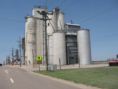
Grain elevators are dangerous places. They too often explode, or the unfortunate worker smothers in the interior storage bins. In the same year the 1916 Union Grain Elevator at Boyd was built, 22 people died because they could not outrun the flames as grain dust exploded at an elevator in the east, at Baltimore. Boyd sits just off The Dalles California Highway (US 197) on the old stage coach and freight road between the Columbia River and the gold fields at John Day. It was the main road between California and the Columbia River Highway until the Oregon highway folks chose a route further west through Dufur in 1923. Grain was lifted from horse drawn wagons up a long conveyor belt to the top of the elevator (note the structure on top the elevator) and dropped by chutes into silos or bins below. The grain was stored 10 or more feet deep. A misstep and a worker could fall into a bin, and as in quicksand quickly sink into the wheat and smother. As recently as last year 10 workers in US grain elevators met their fate in that manner. The Union elevator was built by the farmers in the Boyd area to save them the 12 mile wagon haul to The Dalles on the Columbia River. The Great Southern Railroad built a siding to the elevator, and grain cars could be loaded through a big chute that resembled an elephant's tusk. No record exists of an explosion or suffocation death at the elevator. The pioneer barn at Boyd collapsed last winter. I photographed the barn last June. The cupola that provided airflow to the hay loft was still standing proudly on the roof then. The loft door was a bit askew, but you could still imagine a loaded hay wagon beneath and a farmer throwing pitchfork loads of hay from the wagon up through the door. The barn escaped loft fires generated by oxidation of hay too wet to store (thus the cupola), and the ravages of 100 years, only to succumb to last winter's heavy snow load on a weakened roof. A sad loss. https://youtu.be/1Xx6RyZ6odw1 point
-
Hi Cort, I read your tribute to your father. I'm sure he would have been pleased. Dave1 point
-
Gees, my memories of the Mom and Pop travel business of the late 40's and the 50's come back. We never saw a pool, but I remember the two headed calf in the store window just down the street from the motel in Garberville, California. And I not only remember Magic Fingers, but rooms that featured pay radio. Drop your two bits in the radio and you could listen to an hour of the news on AM. No FM in those days. KGO in San Francisco was a 50,000 watt station. At sundown local stations had to shut down, so 810 on the dial could be heard in Oregon, Washington, etc. It was our connection to home! And even stations in Tijuana came in loud and clear on the road. Microwave, refrigerator, TV......HA. Vending machines, hot breakfast, all night front desk, sundries in case you forgot your razor,.... HA HA. Pillow top mattress, shampoo, hair dryer, air conditioning, mints on your pillow, cookies, etc, etc..... HA HA HA. Yap, the good old days. Dave1 point
-
Neon Arrows Of all the roadside architecture probably nothing beckoned to the traveler more than well lit neon signage. The warmth and glow of the neon could make even the dodgiest of places look decent. Add in a theme that appealed to the restless kids in the back seat, with some animation, and you had a double threat. The Arrow Motel along State Route 68 in Espanola, New Mexico may have had that appeal. A close look at the neon tubes would indicate that they were synchronized to turn on and off to give the appearance of the bow string being released and a neon arrow flying through the air. After sitting vacant since 2000 the Arrow Motel was demolished on Jan 3, 2017 after a prolonged legal battle between the city of Espanola and the owners of the property who had refused to clean it up. The sign reportedly has been relocated to the Glorieta Station redevelopment in Albuquerque, NM. Roadhound http://rick-pisio.pixels.com http://www.rwphotos.com1 point
-
The building just behind Wilkerson's in the photo was a small building with "Figural Bottles" painted on the window. I'm not sure what a "figural bottle" is but the building itself looks lie it may have been the office of a gas station at one point in time. I haven't found much information on it. There may have been a single wide trailer behind the gas station that is peeking into the right side of the below picture. Since we've already explored most of what I saw in Newkirk there was one other building that caught my attention. A little further east on the main road was a building that looked like an early motel with small rooms next to garage ports. I haven't been able to find much information about this building either but it looks to be from an early era of automobile travel. I didn't explore much more of Newkirk other than what was easily accessible from the old highway. There are still residents in Newkirk and I have read that the crime along that stretch of the Interstate is high, as high as 1 in 7 vehicles passing through are involved in illegal activity. The residents there have a reputation of preferring to shoot first and ask questions later so I kept to the main road, quickly took my photos, and moved along. To orient ourselves with layout of Newkirk I present the screen grab from Google Earth: At the top left corner is the UP railroad tracks running on the north side of town The road running up the left side is NM 129 The brown line is the 1936-1964 path of Route 66 The red line is the 1926-1936 path of Route 66 Just below the bottom of the image, south of town is I-40 Roadhound http:\\rick-pisio.pixels.com http:\\www.rwphotos.com1 point
-
Rincon Cafe Driving north out of the Salinas Valley town of Gonzales on the old alignment of US 101, Alta St. as the locals call it, you are quickly surrounded by lettuce and spinach fields. A mile north of town, just before the road turns into an overpass and on ramps, sits the boarded up structure of the Rincon Cafe. The northern end of the building looks to have once been a single bay garage while out front was where the gas pumps sat. The barely visible outline of the letters spelling "Norwalk Service" above the gas station's front door are a clue to the buildings past but still don't reveal what brand of gasoline was once sold there. The cafe on the southern end of the building looks like the type of place John Steinbeck might have stopped at for bacon, eggs and a cup of coffee. Roadhound http://rick-pisio.pixels.com1 point
-
MGA707, I have a few photos from Glenrio that can be seen HERE. A true Interstate Ghost Town. It's definitely worth a stop and a quick look around if you pass through the area again. Be careful though, there is one residence on the east end of the town that does have dogs. Made me think twice about poking around too much. Rick1 point
-
Exit O Along Interstate 40, at the state line between Texas and New Mexico, sits "Exit 0." On the south side of the Interstate sits the Route 66 ghost town of Glenrio but at the exit itself there are 2 abandoned service stations on the Texas side of the state line. It was 1980 when the Interstate bypassed Glenrio and shifted traffic north of the town. It is also likely that sometime around that time period that the two service stations were built. Not sure when they serviced their last customers but today they are left abandoned and exposed to the elements. Abandoned Standard\Chevron station in Glenrio, Texas Pump islands at the abandoned Standard\Chevron station in Glenrio, Texas. Wild sunflowers at the site of an abandoned Texaco station in Glenrio, Texas. Abandoned Texaco station in Glenrio, Texas. Roadhound http://rick-pisio.pixels.com1 point
-
Sometimes you get to see the change as it is occurring. Wells Nevada was once a railroad stop, a town along the Victory Highway, a stop for the night along the US 40, and now a gas stop along Interstate 80 before driving to Elko or Wendover for the night. Prior to the earthquake on February 21st, 2008 the row of storefronts along 7th St that dated back to the time of the Transcontinental Railroad were a premier example of western railroad towns. In 2007, when the photo below was taken, many of the shops were still open. In the case of the Meat Market it wasn't open but still had meat grinders and slicers on the countertop with the meat cases still in place. Wells Nevada, July 2007 When the earthquake hit it damaged nearly all of the historic buildings to the point that they could not be repaired and had to be torn down. When I visited again in Sept of 2018 the row of stores along 7th St. was completely gone. Photo below was taken at approximately the same location as the 2007 photo. Wells Nevada, Sept. 2018 The smoke in the background? Another building gone forever. The building was next to the El Rancho Hotel on Lake Ave. The firemen didn't even try to stop it from burning, only making sure that it didn't spread any further. I'm not sure what the building was built for originally, or used for prior to burning, but it certainly looked old. Image is from Google Earth. Roadhound http://rick-pisio.pixels.com1 point
-
Dave knows this one....located in Durkee, I believe, OR along RT 30 and the Oregon Trail.1 point
-
1934 Rand McNally road atlas, good shape, all pages, only five bucks! Hours and hours of old road enlightenment here. Below are the front and back covers, my state, and my local area:1 point
-
Hamilton, Nevada For a few short years Hamilton was the prominent mining town in Nevada's White Pine County until the ore ran out. Founded in 1868 the town was already in a state of decline when most of it was destroyed in 1873 by a fire that was intentionally set to collect the insurance money. Hamilton hung on after the fire as its population declined and for first couple of years of the Lincoln Highway it was a place to stop before a bypass was cut over Antelope Summit 10 miles to the north. The Hamilton Post Office finally closed in 1931. Today, piles of brick, scraps of tin scattered in the sage brush, and a few remnants of brick walls are all that remains of the original boomtown. The State of Nevada promotes the path from US 50 at Ilipah to Hamilton as a scenic drive and is well worth it if you don't mind a little bit of dust on your tires. The road is easily passable by a passenger vehicle during good weather but a high clearance vehicle is recommended during rainy season when the dirt & gravel road is wet. The road is closed during the winter months. Since my previous visit to Hamilton in 2007 there has been a noticeable decline in the number of free standing rock and brick walls. Back then there were a few archways plus some almost complete walls still standing. Today most of those structures have all collapsed. There is a 1950's era, maybe 1960's, mining operation set up at the southern end of town with a steel shed that is still standing but it too has been vandalized with doors ripped open and bullet holes in the steel walls. Photo from Ghost Towns: How They Were Born, How They Lived, and How They Died by Tom Robotham (Running Press, 1993) gives an idea of what the main street in Hamilton once looked like. This photo of the remains Whitington Hotel was taken in July of 2007 during my first visit. 2018 view of the Whitington Hotel from approximately the same position as 2007. One of the few remaining walls along the main street that is still standing. Piles of bricks where a building once stood. Roadhound htttp://rick-pisio.pixels.com1 point
-
Carrol Station On my first, and only previous, drive on Nevada Highway 722, eleven years ago, I passed by Carrol Station without even seeing it. I was looking for a spot on the actual summit when in fact the building at Carrol Station lies east of the summit by about 3 miles. I'm not sure if it was the foliage surrounding it or I was distracted by the road itself but I totally missed it. This time around I made sure to have the GPS coordinates locked in and my eyes open. There's not a lot of history to be found regarding Carrol Summit other than it was once a Texaco station and also the local watering hole for the nearby mines, which were not very successful. One report speculated that in the early days of auto travel it would have been a good place to stop after the long climb over Carrol Summit when heading east and also a good place to stop and let the engine cool before the final 600 foot climb to the summit when heading west. The station itself likely didn't last much past the re-alignment of US 50 that took place in 1962. It's difficult to imagine a gas station staying profitable when the highway traffic has be rerouted 23 miles to the north. Today the Texaco colors have faded and, all the window glass and doors are missing. Many of the floorboards are missing and interior walls have been stripped away. I always like to check the condition of the roof as once that protection is gone the degradation of the building itself seems to accelerate. In this case the shingles on the roof are mostly still present but extremely worn and crumbling. Undated photo of the Texaco Station at Carrol Station (photo from http://www.onlinenevada.org/articles/highway-50-carroll-station) Approaching Carrol Station from the west. Carrol Station Texaco with concrete sign foundation. No sign of the gas island. Roadhound http:\\rick-pisio.pixels.com http:\\www.rwphotos.com1 point
-
Dave, I'm very sorry to hear about your wife's health and hope that it improves soon so that The Rose can get back on the road. The house at Eastgate is still standing and it looks to be in good repair. I'm not sure if it is occupied but it does look like there has been recent work done inside, although I couldn't tell how recently. Roadhound1 point
-
Hazen Market along US 50A in Nevada I was traveling east on the Reno Highway, US 50-A, having just passed through Fernley headed towards Fallon and points east when my eye caught the Hazen Market sitting on the north side of the highway. The building looked to be no longer in use but in good shape overall with the exception of some weathering on the facade. After taking a few pictures I moved on, postponing any research on the building until after returning home. The information found on Wikepedia is fairly basic: "The Hazen Store is a small complex of buildings in Hazen, Nevada, listed on the National Register of Historic Places. The store provided a stopping point in a remote portion of U.S. Route 50 and served as a focal point in the small town of Hazen. The store was built in 1944 to replace an earlier store that was demolished to make way for a realignment of Route 50.[2] The property comprises the main store, a garage, and a bunkhouse formerly used by the Southern Pacific Railroad. The central portion of the structure dates to about 1904, operating at a different location as a saloon called Shorty's Bar until it was relocated in 1944.[2] The Hazen Store was listed on the National Register of Historic Places on January 28, 2002, as an illustration of a commercial property on the Reno Highway" I also found this article from the Lincoln Highway News from 2008 that shows the building all shined up and looking for new occupants. https://lincolnhighwaynews.com/2008/07/15/road-changes-close-classic-hazen-market-in-nv/ Hazen Market along US-50A in Hazen, Nevada Building that I assume to be the garage mentioned in the Wikipedia article Gas pump in front of the Hazen Market It's a shame that after 70 years of business the Hazen Market has sat idle for the last 10 watching watching the traffic pass it by. Roadhound http://rick-pisio.pixels.com1 point
-
Hello. Tho I am new to this media, blogging, I am not new to American Road. I've been around since the beginning. I do have a road trip web site, but decided to give this blog a try to post my rather infrequent road trips in the Memphis, TN, area. Being nearly 73 years old I'm old enough to remember the good old days of 2-lane road travel. Indeed, I went with my folks in the late 40's and early 50's on several trips from southern Maine to the Dayton, Ohio, area to visit friends and relatives. I look back and think, good old days?? Hot summer days on the road in a 10 year old Chrysler with no AC?? Motels that were more cabin than motel and usually not air conditioned?? Greasy spoon diners - tho most were pretty good. But, it was still exiting for a 10 year old to see what was around the corner. Kids miss so much today on vacation trips on the interstate. And there's not much new around the corner - or down the road, either. Got a Mickey D's in your home town - you'll find many along the road - along with BurgerKing, Wendy's, shopping malls with the same stores. No, kids today miss a lot. Back in 1953 I was crazy enough to go to the west coast, from Maine, with a buddy of mine, on 20 to the mid-west where we picked up 66 to California. Then 101, more or less north to Oregon and Washington, then home to Maine, mostly on 20, but some on 30, 6 and 2. We were celebrating the big transition from child-hood to adult-hood - getting our drivers licenses. At the time, in Maine, you could get a license at 15 - Maine was largely rural and farm land so 15 year olds were expected to drive the family farm equipment, trucks, etc. Can you imagine two 15 year olds driving across country today?? Probably wouldn't get out of the state, to start with. So, I'll probably be posting more on my new blog as time goes by. Won't be every day, won't be ever week. We'll try to find something to add at least inside a six month window. Happy, and safe, travels everybody.1 point
-
One of the main roads through Death Valley National Park is California Highway 190 running from Olancha and US 395 on the west to Death Valley Junction to the east. Along its 131 mile route it passes the constantly irrigated dry lakebed of Owens Lake, over the southern tip of the Inyo Mountains, descends the Argus Range into and across the Panamint Valley, veers northeast over the Panamint Range and into Death Valley before turning southeast and passing through Furnace Creek and exiting Death Valley. In addition to having the distinction of being the lowest road in North America at 282 feet below sea level as it passes through Badwater in Death Valley it also could be the hottest road in North America. As CA 190 enters the western side of Death Valley National Park there is a geographic feature identified on the topo maps as "Rainbow Canyon". The three mile long canyon is a mere 1500 feet wide at the top with 1000 foot tall walls of reds, greys, and pinks that some compare to the Star Wars planet of Tatooine. Pilots that fly through the canyon compare it to the trench that Luke flew on the Death Star in his X-Wing fighter with one difference being that the canyon isn't surrounded by laser cannons but rather Nikons and Canons. The Father Crowley Vista Point (36°21'6.92"N 117°33'2.05"W) sits on the south side of the canyon towards its western end and is a good place to stop, take a comfort break, and get a good view of the canyon. If your lucky you will be standing near someone with a scanner set to a frequency of 315.9 and you will hear the call of a pilot at the Olancha waypoint requesting clearance to the Jedi Transition heading east to Star Wars Canyon. As you look along the canyon to both sides you notice small groups gathered on the hillsides, all excitedly looking west. Soon you notice a small dot pop up over the hillside and quickly descend, growing larger, and heading toward the canyon's western end. As it continues descending into the canyon, its form now readily apparent, the small groups gathered on the hillside raise their telephoto lenses and follow the object, capturing pixels by the gigabyte, as the aircraft passes below them with the sound of afterburners echoing off the canyon's wall. Military pilots know the route between Olancha and a location east of Panamint Springs as the "Jedi Transition". The area around Rainbow Canyon, and Death Valley in general, is known to be the most dense flight-test complex in the world, with aircraft from Edwards AFB, NAWS China Lake, Plant 42, Mojave airport, Nellis AFB, NAS Lemoore, MCAS Miramar and the Fresno Air National Guard Base all using the restricted air space for training and testing. Aircraft as diverse as F-16 & F-18 fighters to B-1 bombers to C-17 Globemaster transports have all been spotted making runs through the canyon. As target rich of an environment as it might sound for the aviation enthusiast it can also be frustrating, and possibly dangerous if you venture outside the parking area. Rattlesnakes are not uncommon in the dry rocky terrain and between the months of April and September temperatures well above 100 degrees, and sometimes close to 120, are common. The best time of year, from a temperature perspective, is between October and March. It's also possible that you could find yourself hiking out to a prime location and sitting all day with no aircraft flying by no matter what time of year you go. A VX-9 Vampire F/A-18F Super Hornet out of China Lake NWS in low level flight through Star Wars Canyon. Royal Danish Air Force F-16 in low level flight through Star Wars Canyon Royal Danish Air Force F-16 crew gives a wave as they exit Star Wars Canyon. Air crews from the Denmark Air Force were based at Nellis AFB as they transitioned to the F-35 Lightning II. Roadhound1 point
-
From the album: US 56: Kansas-Oklahoma-New Mexico
You know you're coming up on a town when you see the grain elevators--Sublette KS1 point -
On my travels recently in Central Oregon I located and visited an abandoned town with a store and Richfield Oil dealer. As is always the case, the store windows are smoked with age and the interior is full of assorted junk. Wonderful because I don’t really appreciate or enjoy restorations in most cases, and because I know the place is intact. Is the eagle I photographed through the window a version of the famous Richfield Eagle? I know of two versions of the eagle. This one is similar to one of them which has spread wings, but the neck of this cast is not elongated. So for you service station pros, any thoughts? Dave Keep the Show on the Road1 point
-
From the album: Veils, Vettes and Vows
1 point -
From the album: Southern California Roadways
US 99 at the North Burbank UP - now gone© Michael Ballard
1 point -
From the album: Barber Museum
1 point -
As far back as I can remember traveling has been a part of my life. From the 1970’s when my family drove to Disney for the first time, loosing a Frisbee in the Smokey Mountains, to watching if our camera will make it through the Chesapeake Bay Tunnel - on the top of our pop-up camper. I can still see the green, wood-sided, Ford Station Wagon we took and sleeping in the back so we could get early starts. I’ve been hooked ever since. In the past few years, I decided to combine my love for travel with my marketing profession. I especially enjoy seeing America from different perspectives, other than the interstate and relating these drives to our (U.S.) history. Who knows where it will lead, but I know it will be a fun ride. While researching and driving our nations byways over the years I’ve come to appreciate good magazines and trusted reference material - magazine’s like American Road. I must confess, over the years I’ve picked up copies here and there, however, it was only recently that I subscribed and I’m glad I did. Since receiving the magazine, not only have I enjoyed the articles, but I enjoy the additional material on their website as well. From time to time I review the on-line archives to see what I’ve missed. However, I’m especially drawn to Foster’s podcasts. These wonderful additions to the written articles provide a very personal perspective to the destination that is difficult to obtain from the written word. A recent podcast with Marsha at the Mermaid Lodge & Motel in Ainsworth Hot Springs, British Columbia is a good example of this personal perspective. In addition to Marsha’s descriptions of the area’s beauty and activities, it was fun to hear about the various artists who visit, and return with their art. However, after listening to the podcast I can’t help but want to see a picture of the “original mermaid”, with or without the bikini. It’s articles like this that make me want to get out and go. With American Roads stamp of approval, I know when I do decide to venture to Ainsworth Hot Springs, my accommodations will not be in question.1 point
-
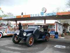
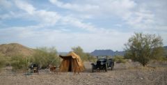
From the album: 1919 Hudson tour on Route 66 - 2010
All this, the Snow Cap Cafe, Route 66 and a dead chicken!!!! Life is good.1 point -
From the album: 1919 Hudson tour on Route 66 - 2010
Set your clocks back 90 years!!1 point