mga707
-
Posts
328 -
Joined
-
Last visited
-
Days Won
4
Content Type
Profiles
Forums
Gallery
Blogs
Calendar
Everything posted by mga707
-

Sampson Trails...follow That Piano!
mga707 replied to Keep the Show on the Road!'s topic in U.S. Highways & Auto Trails
Duh! Now I get it--all of the boxed letters are Sampson Trails, not just the "A" that is used as an example. The old AZ map and the early 66/Santa Fe Trail map and guide are great--thanks! The style of the latter map reminds me so much of early airline schedules of similar or slightly later vintage, of which I have a small collection (I have hundreds of schedules, but only a small percentage are prewar--the oldest from 1930). They're so much fun to read and examine, just as this map and travel guide is. -
Sampson Trails...follow That Piano!
mga707 replied to Keep the Show on the Road!'s topic in U.S. Highways & Auto Trails
Wow--that is quite a map. Don't think I've seen one of that vintage before, just a year after the establishment of the first US highways. Exactly two years ago today I was driving from Boise to Craters of the Moon, and then onwards to Idaho Falls and eventually to Grand Teton, arriving well after darkness fell. What an easy day's drive today, and what a difficult, multi-day journey it was in 1927! Just curious: Are the other boxed letter symbols other marked trails? I would assume that many of those were still around even after the advent of numbered state and federal routes. -
Cooking with napalm! Love it--must've "smelled like victory", to sort of quote Robert Duvall...
-
How 'bout a B-17?
-
What! No Elvis? Bill Haley? Little Richard? Not even any white-bread Pat Boone? Then I saw that the system was developed by CBS/Columbia, so obviously the selections were limited to Columbia artists. And in 1955-56, Columbia was definitely not out there signing up rock'n'roll or rhythm and blues artists (thanks to Mitch Miller, among other things). But again, I digress... Back to the 1917 'car phone': I wonder if any of these actually sold? They sound a whole lot like an early military field radio, which was developed at the tail end of WWI (circa 1917), but was certainly not very 'mobile'. Even the WWII field radios, which are familiar to anyone who's ever seen a WWII movie, were still pretty big and clunky. Those poor radio operators who had to hump those things across Europe and the Pacific needed strong backs!
-
If I recall the details correctly, Chrysler's "Highway Hi-Fi" would not play just any 45 or LP. One had to purchase special discs that were quite thick and heavy and played at a low speed (16 RPM?), much like old Muzak commercial recordings did (Remember them? Back in the '70s I worked at a supermarket that still had an old Muzak record player setup.). The tonearm pressure must have been immense to keep those discs from skipping as the vehicle went over bumps! Oh, and I believe the option was available in any Chrysler, De Soto, Dodge, or, yes, even a low-end Plymouth! Not many folks sprang for it though, as it obviously didn't catch on.
-
Neat shot! No airport there in 1917. IND is one of the best airports in the US, IMHO, but I digress... Looking at my Indy city map, I'm wondering if the bridge is a railroad bridge. Even today there is a RR line crossing Washington (US40) that branches off of the main line (northern boundary of IND, just south of and parallel to Washington) in just about that area just east of what was Bridgeport.
-
Sounds even less practical than Chrysler Corp's. 1950s "Highway Hi-Fi" underdash record player!
-
I do not know, but would love to check it out if/when I'm in the ABQ area again. The '09-'11 Oregon highway map I just received in my travel info packet does show the road as crossing the river, returning to a paved state as it approaches Wasco, so I assumed that at some point in time a bridge had been built at the former ferry crossing. I guess the map is incorrect?
-
The 32% grade reminds me of a passage I read some time ago in a reproduction of a similar-vintage New Mexico "auto trails" book: At that time the auto route between Albuquerque and Santa Fe (which would become part of the original 66 alignment a decade or so later, and today is paralleled by I-25) had a steep grade known as "Bajada Hill". The guide book advised motorists with autos that relied on gravity-feed fuel systems (no fuel pump) to turn their vehicle around at the base of the hill and BACK up the hill so as to avoid fuel starvation! Your Tour Book pages are certainly fascination reading! As luck has it, the Oregon travel info that I ordered for my upcoming August trip to the Portland area (Columbia River Historic Highway here I come!) arrived in yesterday's mail, so I compared the route shown in your 1910 book to the present day. McDonald (John Day Ferry) is not even shown at all on the current official Oregon highway map, and the part of the route from Olex to the John Day crossing is even today still a gravel road. Interesting!
-
 From my Yellowstone historical book: The Canyon Lodge (officially the Canyon Hotel) and the surrounding Canyon Village area was located near Upper Falls. The lodge was open from 1911 through 1958, and burned to the ground while being demolished in 1960. The entire Canyon Village area was removed during that time period and has since reverted to nature.
 -
I did just that three years ago--bought a well-used '99 silver Miata (the first year for the 2nd generation with the headlights exposed rather than hidden) as my 'fun' car. It came with the removable hardtop which I immediately took off and have had stored ever since. Can't see any point in closing up a convertible! The Miata has not been on any road trips farther than to the Phoenix area, though, as it's definitely not as comfortable on long drives as my '05 Pontiac Vibe (NUMMI Motors twin to your Matrix). The Vibe has been by far the best, most trouble-free vehicle I have ever owned. I am sad that the type has been discontinued ('10 Vibe and '11 Matrix are the end of the line) as I was hoping to replace it with a newer same model when the time comes. Guess I'll have to look for low-mileage used when that time comes. The Miata is definitely a fun car and out here (southern AZ), convertible season is year-round: Daytime in the colder months, and now that it's getting hot, one puts the top down once the sun goes down and the beautiful cool evening begins!
-
I received the current issue of the AAA Arizona magazine ("Highroads") today, and learned something new: Since my last Monument Valley jaunt (2004), there is a new lodging option right in the heart of the area. According to the magazine, which ranked MV as the #3 Arizona scenic attraction (behind only the Grand Canyon and Canon de Chelly, and notwithstanding the fact that a good chunk of Monument Valley is actually in Utah!), a Navajo-owned hotel called The View opened in 2009. My sentimental choice would probably still be Goulding's, due to the John Ford/John Wayne/classic film connection that pervades it, but the "chicagochris" might like to know that "(The View) affords a rare photo opportunity when the sun rises between the formations." The article does not specify, but I would assume that The View is probably located within the boundary of the Tribal Park.
-
US 163 runs right through the heart of Monument Valley. Just north of the AZ/UT line is the junction of 163 and Navajo route 42. To the right (when traveling S to N), 42 is the entry to the Monument Valley Navajo Tribal Park. It's a must-stop. The backroad loop through the park, which is just back across the AZ state line, is sandy and unpaved, but accessible in dry weather. It will get you much closer to several of the iconic Monument Valley 'monuments'--the Left and Right Mittens, etc. The park loop road encircles the Totem Pole formation. There is a fee charged, and as it is a Navajo park, NPS passes will NOT get you in free. Turning left on route 42 takes you to THE iconic place to stay in the area: Goulding's Monument Valley Lodge, Trading Post, and Museum. This is simply the place to stay in the Valley. The original trading post is now a great museum with scads of John Ford western motion picture relics and ephemera. Note that since one is in the middle of the Navajo Nation (reservation), alcohol is neither sold nor permitted at the lodge or anywhere in the area. Continuing west on route 42 from the lodge area, you can do a backroads loop on 42 to the village of Oljeto and back, crossing the AZ/UT state line several times. This loop gets you up close and personal with Hat Rock, and you will see lots of traditional Navajo ways, including plenty of hogans. Part of this loop is unpaved, but, like the park loop, is passable in dry weather. Since you are planning to go in late summer, I strongly advise you to do these off-pavement drives early in the day, as the summer monsoon storms build up as the day progresses and you are much more likely to get caught in a thunderstorm in the afternoon. Also please note that the Navajos, for whatever reason, are not big on road signage. Carry along an accurate map! And please don't photograph any person of their dwelling without their permission--it is simply rude! I've truly enjoyed exploring Monument Valley and much of the rest of Navajoland--I hope you will too. Have a great trip!
-
Ash Fork Arizona
mga707 replied to black85vette's topic in National Old Trails Road / Santa Fe Trail / U.S. 66
Very nice! Ash Fork is one of the few places in Arizona on a major highway (two in this case--jct. of 89 and 66(I-40)) at which I have never stopped, even to fill up or look around. -
There are some websites that do this type of thing for a particular movie. I know of a site that has "then-and-now" shots of all of the places around Southern California that "It's a Mad, Mad, Mad, Mad World" was filmed in 1962/63. The changes in less than 50 years are simply amazing! While I have not taken pictures, I've done the same thing for two productions that were shot in and around my hometown of Tucson back in the same year, 1962. I've searched out locations for both the Oscar-winning motion picture "Lilies of the Field" and for the pilot episode of the classic TV drama "The Fugitive". 1962 was a busy year for filming in Tucson! And again, the changes that have taken place in the intervening years are vast--"LotF"scenes that were open desert in '62 are in the midst of decades-old subdivisions today.
-
I loved the book--recommended it on this site when it came out a couple of years ago. The HST Nat'l. Historic Site in Independence is the obvious place for the New Yorker to end up. It looks restorable, and there are plenty of old Chrysler Corp. buffs out there (hello, Richard Carpenter!).
-
old US 80/Bankhead Highway east of Tucson
mga707 added images to a gallery album in Member's Gallery
Some shots I took between Tucson and Benson AZ, including the famous Marsh Station Road segment of old 80. -
-

From the album: old US 80/Bankhead Highway east of Tucson
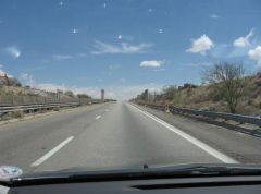
Another old concrete bridge on what was the 1930s-era US80, now a dead-end I-10 frontage road segment that runs for 2 1/2 miles west of the Vail exit (279). -
From the album: old US 80/Bankhead Highway east of Tucson
-
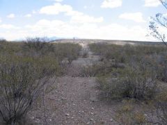
From the album: old US 80/Bankhead Highway east of Tucson
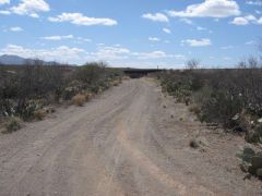
I believe that this may also be another segment of the 1921 Bankhead Highway alignment. It veers off from the 1933 US80 alignment (Marsh station Road) just north of the Cienega Creek bridge. This section is still drivable (notice tracks), and I believe it is used for utility easement, as there are buried cables and/or pipes along this stretch. Note: Technically I was trespassing here, as I was just inside the Cienega Creek Preserve boundary, and should have had a BLM permit. -
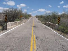
From the album: old US 80/Bankhead Highway east of Tucson
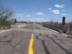
The "fine 1933 bridge" that Jeff Jensen mentions on p.52 of his fantastic book, "Drive the Broadway of America". -
From the album: old US 80/Bankhead Highway east of Tucson
A segment of the original 1921 Bankhead Highway (also the 'Broadway of America' and the 'Old Spanish Trail') alignment, which generally but not exactly follows the 1933 alignment of US 80, now Marsh Station Road. This was shot from the south side of said road, near the 1933 small concrete bridge that is east of the 1921 Cienega Creek bridge. -
From the album: old US 80/Bankhead Highway east of Tucson
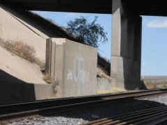
...and this is the other side of what was the same overpass. -
From the album: old US 80/Bankhead Highway east of Tucson
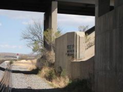
This is one side of the old 80 railroad overpass that is now between the east- and westbound lanes of I-10, Exit 292 (Empirita Road).