


mga707
-
Posts
328 -
Joined
-
Last visited
-
Days Won
4
Content Type
Profiles
Forums
Gallery
Blogs
Calendar
Everything posted by mga707
-
Just returned from a week-long trip through four of California's iconic National Parks (Sequoia, Kings Canyon, Yosemite, and Death Valley) and the Mojave National Preserve. One of the highlights of the week was spending two nights at the wonderful Amargosa Hotel and Opera House in the near-ghost town of Death Valley Junction, resident population 3 in winter, 1 in summer. Others commute from Amargosa Valley or Pahrump NV. The history of this town, which was originally a rail junction and is still a road junction (CA state routes 190 and 127), is too long to go into here but is fascinating, if one wishes to look it up. The name of dancer/actress/artist Marta Becket figures prominently in the town's history and why there is still a functioning opera house in a town that for all intents and purposes has ceased to exist. Highly recommend the hotel to anyone planning to visit the Death Valley area. Enjoy some photos of the hotel and surrounding structures: Former garage and gas station across the highway from the hotel. The hotel and opera house at sunrise.
-
It's 1934. And the western terminus of 66 is in Los Angeles, hard to tell exactly where. The Los Angeles city map in the back is stingy with US highway shields. The farthest west 66 shield shown is in Monrovia. Also interesting is that California is one of the few states that did not by that time have a numbered state highway system. Only US routes are shown on the combined California/Nevada map, and now California state shield is shown for reference, unlike nearly all other states. The variety of state highway shields is amazing! Arizona's had a 'backwards' swastika on theirs, which was a Navajo symbol before that idiot in Germany ruined it forever. You can see ti above, inside of the arrowhead, which in turn is inside of the detailed state outline. Current AZ shield is a very simplified and 'stylized' rendering of our state's shape.
-
1934 Rand McNally road atlas, good shape, all pages, only five bucks! Hours and hours of old road enlightenment here. Below are the front and back covers, my state, and my local area:
-
 Minor correction: The correct name of the national park is Petrified Forest National Park. The Painted Desert itself occupies the northern third or so of the park, and extends outside the park boundaries to east, north, and west. The entire park is a wonderful place.
 -
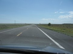
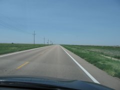
The Great Plains--US 56 heading pretty much straight-arrow to the southwest through southwest Kansas, the Oklahoma 'panhandle', and northeastern New Mexico. Came within a few miles of the southeast corner of Colorado and right after crossing from Oklahoma into New Mexico (the shortest state-to-state land border in the US, BTW) we were close enough to the northwest corner of Texas to spit into it!
-
-
From the album: US 56: Kansas-Oklahoma-New Mexico
Just after crossing from Oklahoma into New Mexico. Corner of Texas to our left. -
From the album: US 56: Kansas-Oklahoma-New Mexico
Southwest corner of Kansas, right before the Oklahoma line. -
From the album: US 56: Kansas-Oklahoma-New Mexico
Sublette KS -
From the album: US 56: Kansas-Oklahoma-New Mexico
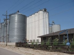
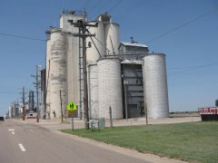
You know you're coming up on a town when you see the grain elevators--Sublette KS -
From the album: US 56: Kansas-Oklahoma-New Mexico
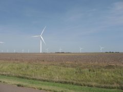
'Wind farm' near Dodge City KS -

From the album: US 56: Kansas-Oklahoma-New Mexico
Larned KS -
From the album: US 56: Kansas-Oklahoma-New Mexico
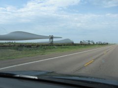
Near Dodge City KS -
Just saw the sad news that the historic summit Inn restaurant at the Cajon Pass summit in California has been totally destroyed by the current wildfire. If anyone has more details, or pictures, please post.
-
Great pictures! Only been to Butte one time (1999), and for way too short of a visit, but I loved it. Seems so 'authentic', not fancified for tourists and rich visitors.
-
Love Isn’T Just For Subaru, A Dying Breed & Trains
mga707 replied to knightfan26917's topic in General Discussion
Took the Alaska Railroad from Anchorage to Fairbanks, with a two-night stopover in Denali National Park, in the summer of 2010, and thoroughly enjoyed it. Still more of a car/plane guy than a train guy, but an overnight train trip is something I would like to experience when I have the time (come on, retirement!). I think cross-country might be a big too long, but I'd love to do the Canadian rail trip between Vancouver and Calgary, or v.v., across the Rockies. -
Have not heard of that particular LP, but it sounds like a small label's response to "Big Sounds Of The Drags!", an LP of dragstrip audio that was released on Capitol Records in late 1963 and reached #27 on the "Billboard" album chart in early 1964.
-
Enjoyed it very much! The 'then-and-now' feature is outstanding. Thanks for posting them.
-
That piece of road is in amazingly good shape for a 101-year-old! I'd love to see it if I ever get up to the top half of Indiana--I visit frequently but always to the bottom half.
-
Deja vu. Attempted to send a page via e-mail. The 'captcha' anti-spam device would not work. After indicating that I had assembled the image correctly, it then said it was incorrect when I tried to send the email. The most recent Lincoln Highway thread is the one i was attempting to send.
-
Great picture! I've seen the building from I-40 but have not been close-up--yet!
-
Tamales in Mississippi, who would've thought? I'll have to try a 'Delta Tamal' (the proper singular of the plural 'tamales' is 'tamal', not 'tamale') if and when I'm back in that area to compare it with our 'Sonora-style' Southern Arizona tamales.
-
Lots of drivable remnants of old US80 on the OST routing, at least in AZ and CA. And, of course, the Old Plank Road that the BLM has preserved in the dunes west of Yuma. As far as the heat, a well-maintained modern vehicle can handle it. Just this past Sunday I drove home from LA on I-10. The reading on my car's outside thermometer was at 110 or over all the way from the Palm Springs area to the east side of the Phoenix valley, where welcome thunderstorms and much-needed rain dropped it down to the mid-80s in a hurry. The peak temperature was reached west of Blythe at 115. Right around the Chuckwalla Road remnant of old US60/70, which I was sorely tempted to drive, heat or no heat. Alas, I was in a hurry to get home and the siren song of steady 75mph motoring was too strong.
-
Thank you for your response. The page was "Wonderland Way". I retried sending it just now and it worked perfectly.
-
Hello? Anyone there?
-
Tried multiple times to send a thread as email. "Captcha" timed out every time.
