


Michael Ballard
-
Posts
129 -
Joined
-
Last visited
-
Days Won
17
Content Type
Profiles
Forums
Gallery
Blogs
Calendar
Everything posted by Michael Ballard
-
 Great photos of the old highway and gorge. You mentioned about those floods. Some of the numbers that came out of those floods are truly staggering. At Wallula Gap, east of The Dalles, the flow was estimated to be between 6 and 10 cubic MILES of water per hour. Rivers tend to be measured in cubic FEET per second. Huge difference. The flood, at its highest point, filled the Columbia River Gorge nearly to the top. Imagine the view from Crown Point along the Columbia River Highway with the gorge completely filled with water. There are other features from the floods, yes, floods, that defy imagination. These floods happened at least 35-40 times. The geologist, J. Harlen Bretz, that came up with the original theory was basically laughed at by the scientific community until another geologist, Pardee, came up with the source of the water. It is a fascinating story and something that always gives me pause when I am in that region.
 -
I finally posted a followup to the tour. http://socalregion.com/cajon-pass-tour-august-12-2017-review/ The next tour will be advertised a bit more, but I still will just do it myself. I don't intend to collect monies for the tours just yet. Having some other group handling it wouldn't quite fit what I do. My next tour will either be on US 80 or US 99 (what section is still being looked into).
-
While it looks like it will be a low turnout (still no real idea until I show up that morning), I still intend to make the best of it. It should be a lot of fun, despite the heat predicted.
-
The tour will include as much of the original roadway as possible as well as the last pre-freeway alignment. There are sections remaining, that will be viewed, of the 1916 macadam paving.
-
What's Your Favorite National Park?
Michael Ballard replied to beckyrepp's topic in American Road E-Newsletters
I saw the article in the magazine. Very cool to see! Thank you for the opportunity to contribute. -
Plans are getting a bit more set for the Cajon Pass tour. The start location has changed to Devore. More details can be found at : http://socalregion.com/august-12-2017-cajon-pass-highway-tour/
-
I am hosting a tour of a portion of the Cajon Pass on August 12, 2017. It will cover the highway from the San Bernardino train station to Cajon Summit. The tour will be in a caravan with designated stops. If anyone is interested in this, please let me know. More details will follow soon.
-
Back in the late 1940's, there was a rather treacherous curve on US 80 between Viejas and Descanso. Today, there is nothing but a large road cut and a vista point. The original plan, however, was to built a tunnel to bypass the curve. It was never built but provisions were made for it at the time. I posted some information about the plans on my site - http://socalregion.com/a-tunnel-on-us-80/ Enjoy!
-
Does anyone have any updates on US 99 through California, Oregon, or Washington? Plenty is going on here in California. A section of the highway near Fresno is being realigned to accommodate the new high speed rail. A portion of old alignment is also being removed as well, bypassed about 1960. In Southern California, there has been much work on the section of US 99 in the San Fernando Valley. A pipeline replacement project has partially torn up San Fernando Road in the north end of Glendale, a section which also had old curbing. Burbank is also doing a lot of resurfacing along their stretch, with Caltrans replacing the former North Burbank Underpass with a re-realigned (going back to the original alignment actually) San Fernando Blvd. What's new in other areas along US 99?
-
What's Your Favorite National Park?
Michael Ballard replied to beckyrepp's topic in American Road E-Newsletters
The Colorado Plateau is certainly a spectacular area for scenery and geology, as the photos you presented show. That region is one of the better, and certainly easier to see, displays of mostly Mesozoic sedimentary rocks. The rocks of Bryce Canyon are a bit younger, being early Cenozoic. The scale of some of those formations is quite amazing. -
Help Make The Ultimate Road Trip Playlist
Michael Ballard replied to Sue H.'s topic in American Road E-Newsletters
"Middle of the Road" by The Pretenders is another one. Call it misheard lyrics, but part of it says "Gotta get up 33 baby"... I think it actually says "Gotta get up really early" or something. Thing is, I was in Taft, California heading up State 33 at the time. So, another song that is a good road song. -
Help Make The Ultimate Road Trip Playlist
Michael Ballard replied to Sue H.'s topic in American Road E-Newsletters
Some of the music I listen to is synthwave style, similar to 1980's synthesized music. An interesting piece, "Motorcycle Cop" by Power Glove. My husband thought it reminded him of traveling through downtown Los Angeles on the Harbor Freeway (State 110) on a motorcycle at night. It is certainly good night traveling music. -
Help Make The Ultimate Road Trip Playlist
Michael Ballard replied to Sue H.'s topic in American Road E-Newsletters
"Road to Nowhere" by Talking Heads "Once in a Lifetime" by Talking Heads (with the line "Well, where does that highway go to?" I'll see what others I can think of. -
After reviewing some photos I had taken on previous trips, I found enough to extend my US 6 tour from its old terminus in Tonopah, Nevada all the way to the Utah State Line east of Ely, Nevada. The tour is finally "done". I don't think I can go much further east for some time, as I lack quite a bit of photos and information about the road's journey through Utah. Maybe one day. I've at least taken the roadway to I-15 and done other parts in Utah and Colorado. http://socalregion.com/highways/us_6/ Enjoy! PS - The tour is now about 620 miles long, so if you wish to follow the whole thing, it might take a while.
-
In the San Gabriel Mountains, above Azusa, California, there are two roadways from two different periods that were both abandoned. One, the "Road to Nowhere" was to be a part of the East Fork Road that would have eventually traversed the range and ended near Big Pines. This attempt was abandoned in 1938 after a devastating flood that destroyed four of the five miles built, leaving an arch bridge and tunnel a long ways from anything. In the late 1950's, though ending in the mid 1960's, another attempt was partially constructed. This time, a higher approach was to be used which was planned to connect to the "Bridge to Nowhere". This was also abandoned, leaving a partially finished roadway and two tunnels behind. I hiked to the "Road to Nowhere" yesterday in a wetsuit with my husband and we are both quite tired. Still, it was a lot of fun and very beautiful. A while back, I posted some additional information on my site, which has photos and more detailed information about the roads: http://socalregion.com/road-building-in-san-gabriel-canyon/
- 1 reply
-
- 1
-

-
What's Your Favorite National Park?
Michael Ballard replied to beckyrepp's topic in American Road E-Newsletters
Of all the National Parks I have visited, my favorite is always Death Valley National Park. I highly recommend a visit to Death Valley National Park, during winter, for all aspiring geologists and earth scientists. Death Valley offers much more than most may think. As a geologist, there is much to see throughout the park. Over 800 million years of Earth history is represented there, from the late Precambrian to the Holocene. The park also offers an interesting look into what life was like for explorers, settlers, miners, and natives alike. Sometimes the beauty of the place is hidden, in time, which is something I enjoy exploring each time I go. A good example of this would be the dry lake bed of Lake Manly, which used to be over 600’ deep and over 100 miles long. The beauty of this once vast lake, while lost to the naked eye, can still be seen if you look hard enough at what it left behind. Salt flats, shorelines, fossils, and other features still tell the tale and still allow visitors to see and experience that period in time. I always look forward to my next visit to the park and can’t wait for my visit this year. -
Oh I know. Mind you, when I'm in full leathers with a mohawk on my helmet, I might look like a daredevil. Much to the chagrin of others, I turn out to be just a regular rider in full gear. I'm going to try a "voiceover and photo" short video soon. Gotta test out some ideas.
-
Right now, I'm not planning to do a motorcycle video. I don't consider myself to be a daredevil nor see that there is a big market for the videos. The ones that I have done have merely been to record highways and I posted them as such. The videos I plan to make are more documentary style with me speaking at some location about said location. Still need to upgrade the equipment as the gopro has limitations in that regard. We'll see where it goes. I never thought my website would have as much it is does nor be linked in the places it is. Either way, even making these videos should be a lot of fun and I am looking forward to that.
-
Well, after running into some small technical issues, the video idea is a bit delayed but feasible. I'll see what sort of video shorts I can come up with in the next month or so. Should be a lot of fun.
-
That is a pretty neat idea. A nice way to tour a roadway and get a feel for what it is like.
-
I have been having another thought about this finding old roads thing. I have a gopro camera. I've used it to video some now removed sections of roadway, such as the North Burbank UP on US 99 in Burbank, CA as well as the Soto / Huntington Viaduct, a former Pacific Electric grade separation. I no longer have a mount on my motorcycle helmet but can mount it other places. What I haven't done is do anything with a narrative. Would there be interest in some sort of narrative video where I describe certain roadway features? Could be a lot of fun too.
-
Photos of historic roadways throughout Southern California
-
-
From the album: Southern California Roadways
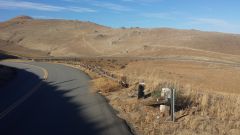
US 466 near Bealville, CA in the Tehachapi Mountains© Michael Ballard
-
From the album: Southern California Roadways
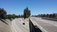
US 99 at the North Burbank UP - now gone© Michael Ballard
-
It looks like the 1938 Santa Clara River bridge, the last remaining structure along the 1939 Newhall-Saugus Bypass will be replaced. Not terribly surprising in that town, considering how much development has occurred in the area. The new bridge will be a bit wider, with sidewalks. The parallel 1968 bridge is also being widened at the same time. The idea is to join the bridges and create a more seamless roadway. While I already have photos, I plan to do a full photo shoot in the next couple weeks, assuming it doesn't rain on the weekend I can go. For the location and what the structures look like today: http://www.socalregion.com/highways/us_6/us6012/