


Search the Community
Showing results for tags 'california'.
Found 21 results
-
 The Ridge Route Preservation Organization was cleared by the Angeles National Forest to repair potholes along the north section of the Old Ridge Route from the 138 to the Tumble Inn. The intent is to preserve the road and make it more accessible to the public as well as emergency services. Filling the potholes can reinforce crumbling sections of the road as well as prevent further damage to the original road surface. The Ridge Route Pothole Project will begin in spring of 2024. These improvements don’t only serve to protect the history of the Ridge Route, the repairs will also serve everyone who passes through the area. It’s a large stretch of open land that provides recreation for hikers, cyclists and hunters as well as being a heavy fire danger area. It’s important that emergency vehicles have quick and easy access when mere seconds matter. A donation of $15 buys a 50 pound bag of asphalt cold patch. For volunteer and donation info visit our Project website at https://ridgeroute.org/pothole-project.
 -
Recently, I became a member of the board for the Ridge Route Preservation Organization. One of my first acts was to help create a new website for the group. The Ridge Route Preservation Organization is a group that is working to get the roadway open and maintained again. I do believe we will be successful in this venture. The new website, http://ridgeroute.org , will act as a newsletter, give updates on the roadway, and help raise funds for our effort.
- 3 replies
-
- 1
-

-
- us 99
- ridge route
- (and 1 more)
-
It looks like the 1938 Santa Clara River bridge, the last remaining structure along the 1939 Newhall-Saugus Bypass will be replaced. Not terribly surprising in that town, considering how much development has occurred in the area. The new bridge will be a bit wider, with sidewalks. The parallel 1968 bridge is also being widened at the same time. The idea is to join the bridges and create a more seamless roadway. While I already have photos, I plan to do a full photo shoot in the next couple weeks, assuming it doesn't rain on the weekend I can go. For the location and what the structures look like today: http://www.socalregion.com/highways/us_6/us6012/
-
It would appear that San Bernardino County is planning to replace a few of the bridges in the Mojave Desert crossing. Three bridges in particular were heavily damaged in storms a few years ago (2014 I think) and the roadway remains closed in places today. Check out this site for information about this plan. http://cms.sbcounty.gov/dpw/PublicNotices.aspx#29397
-
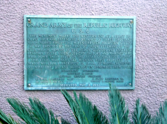
From the album: US-6 - The Longest Highway
Perhaps because this was the longest US-numbered highway, perhaps because the Grand Army of the Republic organization had adopted it, someone installed a plaque to mark the end of the highway. It was dedicated in May, 1953 and reads, in part, “This monument marks the western end of a coast to coast highway, extending a distance of three thousand six hundred fifty-two miles, through fourteen states.” The occasion was a gathering of five service-related organizations, including the Sons of Union Veterans of the Civil War. The plaque was originally located in front of the Municipal Auditorium, but when that building was demolished sometime in the 1960s, it was moved to the Long Beach Performing Arts Center. It’s interesting to note that neither of these buildings was out at the corner of the Pacific Coast Highway and Atlantic Avenue, where maps have shown the actual end of the route. Because of this, some have theorized other locations for the original end of US-6, such as the interchange of the Long Beach Freeway at Pacific Coast Highway, or the Los Alamitos traffic circle, or even south of the Pacific Coast Highway at the Performing Arts Center. At any rate, it the end of my US-6 Roadtrip!© © 2017 - Milne Enterprises, Inc.
-
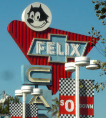
From the album: US-6 - The Longest Highway
Felix Chevrolet has been selling cars on Figueroa Street since 1921 and has a wonderful neon sign out front featuring Felix the Cat. The Felix character was borrowed from the popular cartoon "Felix the Cat" by pioneering automobile dealer Winslow Felix, who was a friend of filmmaker Pat Sullivan, whose animation studio created character. The original sign was erected in 1957 and a newer version has been added one block north. As we’re driving a 1962 Chevy Impala, this would be an appropriate place for a maintenance check. I should note that I’m staying on Figueroa Street even though US-6 had been moved onto the Harbor Freeway by 1962. The freeway is only 1-2 blocks off the street, so on this Day 36 of my US-6 roadtrip we’ll be passing the same places, but we will get to see more, and stop whenever we want, on the old road.© © 2017 - Milne Enterprises, Inc.
-
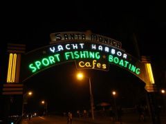
From the album: Route 66 tour 2011 album 2
The Santa Monica Pier. Considered The end of Route 66 (although it actually ended a few blocks East). -
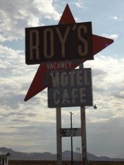
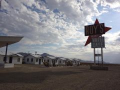
From the album: Route 66 tour 2011 album 2
Roys Motel and Cafe in the Mojave Desert in Cali. This was the location for the filming of the movie "Beneath the Dar" -
From the album: Route 66 tour 2011 album 2
Roys Motel and Cafe in the Mojave Desert in Cali. This was the location for the filming of the movie "Beneath the Dar" -
From the album: Route 66 tour 2011 album 2
Roys Motel and Cafe in the Mojave Desert in Cali. This was the location for the filming of the movie "Beneath the Dar" -
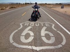
Really long lonely stretch Of 66 In Cali
Brainbucket Mike posted a gallery image in Member's Gallery
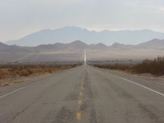
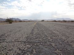
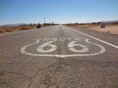
From the album: Route 66 tour 2011 album 2
California had some great, long lonely stretches of Route 66 through the Mojave. -
From the album: Route 66 tour 2011 album 2
California had some great, long lonely stretches of Route 66 through the Mojave. -
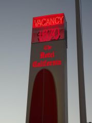
From the album: Route 66 tour 2011 album 2
Such a lovely place..... -
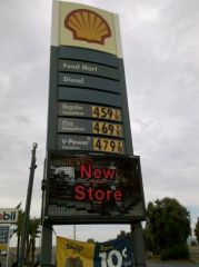
From the album: Route 66 tour 2011 album 2
This was in Needles California. The price for regular gas was $3.29 right across the border in Arizona. -
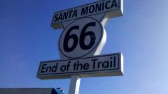
From the album: Route 66 tour 2011 album 2
The End of the Trail on Santa Monica Pier. Sign made possible by Mr. Dan Rice, Route 66 Roadie extrordinaire. -
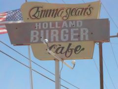
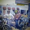
From the album: Route 66 tour 2011 album 2
A great place to eat on Route 66 in Cali. One scene from Kill Bill was filmed here. -
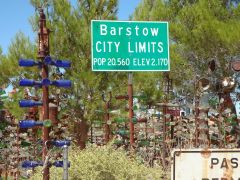
From the album: Route 66 tour 2011 album 2
Elmers Bottletree Ranch on Route 66 in Barstow CA. -
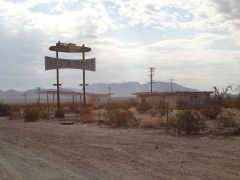
From the album: Route 66 tour 2011 album 2
Near The Bagdad Cafe on Route 66 in Amboy California -
From the album: Route 66 tour 2011 album 2
Near The Bagdad Cafe on Route 66 in Amboy California -
From the album: Route 66 tour 2011 album 2
The Bagdad Cafe on Route 66 in Amboy California. Filming location of the movie by the same name -
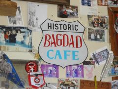
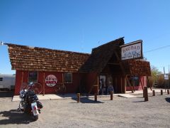
From the album: Route 66 tour 2011 album 2
The Bagdad Cafe on Route 66 in Amboy California. Filming location of the movie by the same name.
