


Keep the Show on the Road!
-
Posts
2,829 -
Joined
-
Last visited
-
Days Won
26
Content Type
Profiles
Forums
Gallery
Blogs
Calendar
Everything posted by Keep the Show on the Road!
-

Everybody Loves Dino Sometime....
Keep the Show on the Road! replied to Jennifer's topic in General Discussion
Great post! Looks like a good time was had by all! Keep the Show on the Road -
From time to time I come across a little bit of esoteric road stuff that might be of interest to one or two deeply obsessive roadies like myself. This is one of those. If you have a life, you can skip the rest of this post! The other day I picked up a vintage 1925 catalog of pre cut homes you could buy back then as a package and put up yourself. Beyond explaining a whole bunch of look alike houses from that period I had observed in the Los Angeles area, it contained on the last page a pre cut one room school house and two pre cut service stations which are shown below. The stations are classic mid 1920’s, as you would reasonably expect. Then I recalled the station on the Yellowstone Trail at Rosalia, Washington, and pulled up the photo. Shucks! Not a precut, but no question about the architectural similarity. So if you are dating roadside artifacts (buildings, not hitchhikers) you now have a reference to the design characteristics of service stations of the mid 1920’s. Big deal, right?! BTY, didn’t the big oil companies have their own metal pre fab stations? Maybe they still do, but I recall something like that years ago. Keep the Show on the Road!
-
The American Road Magazine interview with Marta Becket, noted former New York dancer, now at Death Valley Junction, was great! This past winter we were wandering the southwest and traveled through Death Valley. In what seemed like the most unlikely spot, we came upon an old time desert oasis; Death Valley Junction. Frankly, we didn’t know what we were looking at. We stopped and were greeted by several tame peacocks and a variety of buildings with the look of a 1920’s desert community, complete with an opera house! All I could think was that here was a fine example of what a 1920’s or 1930’s traveler would have seen motoring the old two lane roads through the great American desert. All except the opera house, which was a puzzle until we read a small sign. Peacocks at Death Valley Junction Things were pretty quiet in mid winter, and only a few vehicles passed by while we were stopped. I took a few quick photos with my pocket camera and then we took State Line Road toward Pahrump and Las Vegas. Of course now I wish we had stayed longer and looked around a bit more! Part of the Hotel and the Opera house at Death Valley Junction. The great interview with Ms Becket tells the story we missed, but I have included some photos of the scene we encountered. The Opera House and hotel complex is well maintained and on the west side of the road. On the other side of the road is a vintage abandoned gas station, not so well maintained, but interesting to any roadie. The Abandoned Service Station. Gasoline here in 1935 was 25 cents a gallon. The sheer incongruity of an opera house in the middle of the desert complete with famed performer makes Death Valley Junction worth a visit. When you add the prospect of a delightful performance as described in American Road, its time to buckle up the ‘ole seat belts and hit the road. You can stay at the hotel, at Furnace Creek or in Pahrump. Death Valley Junction (and the buildings there now), once served as headquarters for the producers of Borax. You don’t see it as much now, but as a kid, we used to scrub our hands with Boraxo from a black and white tin that featured the famed 20 Mule Team. And just about every service station restroom once had a white Boraxo hand soap dispenser. In 1935 the H. M. Gousha Guide observed that the town was occupied mostly by employees of the Pacific Coast Borax Company.. You could get a meal at the coffee shop for 75 to 85 cents ($11.38 - $12.90, inflation adjusted), and a double room at the hotel was $4.00 ($60.72 - inflation adjusted). Remembering that 1935 was near the depth of the great depression, I suddenly feel better about travel costs today! An Excerpt from the 1935 Gousha Guide The 1935 Guide states that gas here was 5 cents cheaper than in Death Valley. The price of gas in Death Valley was 30 cents, so at Death Valley Junction it was 25 cents (inflation adjusted = $3.79 today). To American Road Magazine...thanks for the rest.... and the best of the story! Keep the Show on the Road!
-
American Road Outdid Itself (again!)
Keep the Show on the Road! posted a topic in General Discussion
You folks outdid yourselves on the current issue of American Road. It was so lively it almost jumped in my hands! I haven’t read every piece yet, but I was so pleased with what I did read, I’m sending another gift subscription to a friend. The Route 61 piece did a great service for what I consider the most under appreciated road travel destination in America, Mississippi. I shouldn’t quip, but apparently God hangs out there as well...at least Morgan Freeman does, based on the photo and story . Amy C. Elliott did a wonderful job on the photos, and I assume she did the writing as well. The pink cover theme is pure 1955, complete with the Elvis 55 Cadillac. We actually wore clothing with that color pink in those days! The heads up on Tony Craig’s upcoming book was appreciated. The sample photos definitely caught my attention. And Tony’s piece on Lodi was great. Old 99 (the Pacific Highway) deserves more attention. I must be losing it, but I even enjoyed the ads. Nothing pretentious,...just a great celebration of two lane travel. I picked out a few places to visit. I guess all I can say is “Can it get any better?!” It's easy to see, I've some fun reading ahead! Keep the Show on the Road! -
Denny, Good stuff as usual on your site. The video system(s) at the new center looks innovative. What was your impression of its effectiveness? It does seem you experienced more "closed" places than might be expected in mid June. None the less, it sounds like fun. Keep the Show on the Road!
-
I like that SIR thing. Much better than what my wife sometimes calls me! Let us know what you think of the photos. I find them quite amazing, especially the shots of auto camping, stuck in the mud, or at some recognizable site that still survives along the old alignment. The shot of the road construction equipment in the article you cite looks like the same countryside shown in the South Bend photos in the collection. They were probably taken in the same general area. Being in the west, I have followed the Lincoln through Nevada and into Utah. Many of the places photographed in the teens and 20’s and in the U of M collection still exist on the Lincoln. Of course, you guys in the midwest have lots of sweet sites as well, as I see in your photos. Keep the Show on the Road!
-
Denny, I assume your sister is the good looking member of the family. In the category of trivia and nostalgia: The Landcruiser was top of the line in the upscale Studebaker Commander series, pegged at $2265 (equal to about $19,500 today) in 1948 and tugged along by an in line 6 claiming 94 bhp. It weighed in at 3280 pounds, so it was a fair chunk of metal to move with that horsepower. Of course I wouldn't know, my family couldn't afford one. A friend who was a "Ham" operator, had a used one of that era we drove over the old Santa Cruz Highway one night in the winter of 1954 or 1955 to carry supplies to flood victims in Watsonville (California) during a major storm. What I remember most was that the vacuum powered wipers stopped working as we pulled the long grade out of Los Gatos, and he had to let his foot off the gas every so often so we would get a couple of flops of the blades to clear the rain off the windshield. Dodging downed trees in the dark of night while driving half blind in the rain was all part of the two lane adventure! And, Mobilene, suck it up! We all make sacrifices! If you are to be a Road Scholar as Becky suggested you are, you gotta do your homework!! Let's Keep the Show on the Road!
-
Glad your Mom was thinking of you! The article is interesting. There are at least a dozen Lincoln Highway photos taken near South Bend in the outstanding, terrific, wonderful, University of Michigan Lincoln Highway collection. The URL for the collection is: http://images.umdl.umich.edu/cgi/i/image/i...&page=index The collection covers most of the Lincoln Highway in thousands of photos, and more are being added thanks to the modern Lincoln Highway Association and a donor. Before you click on the link, check your watch. You may get so interested you lose track of time! The collection is of interest far beyond the Lincoln Highway because it captures so much of the taste of early auto travel. Keep the Show on the Road!
-
New Road Travel Web Site
Keep the Show on the Road! replied to Alex Burr - hester_nec's topic in General Discussion
Thanks for the great tip! If nothing else, their site proves that you can’t lose if you stay on the two lane roads! It is well done. The windmill gas station in one of the photos is a new one to me, but then I haven’t been on Route 67! It may be just a case of “the grass looks greener” but every time I see another road trip in the mid west, I get the road trip urge. Maybe it’s because I have traveled virtually every two lane road of consequence in the western states, most multiple times, and the mid west is unfamiliar territory. Anyway, I’m going to go armchair cruising on 67. Thanks again for the tip. Keep the Show on the Road! -
New Web Site Featuring Iowa's Auto Trails
Keep the Show on the Road! replied to RoadDog's topic in General Discussion
RoadDog, I missed this post when you first put it up. Thanks for the heads up! The Iowa DOT has done a nice job of recognizing historic roads. It will certainly add to a trip there. Thanks again! Keep the Show on the Road! -
I mentioned in another post that one indicator of an old road alignment was the existence of water fountains by the roadside, especially on long grades. Beyond the value to thirsty travelers, the old fountain was a necessity to provide water to cool a radiator or stop vapor lock (the boiling of gasoline in the gas lines, preventing it from reaching the carburetor). The roadside water fountain was the subject of the lead article in the April 1930 Public Roads Magazine. It is probably a sign of advanced age and the onset of senility to even care about old roadside water fountains! But there was an undeniable pleasure on a hot day when you pulled off the highway under the shade trees surrounding a water fountain, and took a big draw on that cool elixir. The freeway rest stop has bigger facilities, but lacks the social interchange of the old water fountain. When road travel was an adventure, and not a rush to a destination, people talked to one another at the old fountains, compared where they had been, what they had seen, and got information about sights and the road ahead. “Did you see the Trees of Mystery,” “How is the road over the pass?”, “We stayed at The Pines and they even have a pool!” Some of the fountains pictured still exist. The one at Tub Springs has been fixed up and is still a nice stop on State 140. It is also at the site of a spring along the old Applegate Trail branch of the Oregon Trail, so it has been the source of a refreshing drink for at least 160 years! This is the Quintessential Northwest Roadside Fountain Tub Springs on State 140 between Klamath Falls and Medford, Oregon
-
I remember reading about this practice on the trails in Oregon going from the Willamette Valley to the Coast. As you get thoroughly seeped in the two lane roads, it is hard not to pick up some of the old pre automobile travel characteristics and stories. Another story that always brings a chuckle is what you did when two wagons met in a place where neither could go around or back up, as on a narrow road on a hill. One party had to disassemble their wagon and either stack it on the side or carry the parts around the other. No wonder the horses had bells to warn of their approach! Let’s Keep the Show on the Road!
-
What Were You Doing When You Became Addicted?
Keep the Show on the Road! replied to RoadDog's topic in General Discussion
Ah, RoadDog. 2002 indeed. Try 1948. I’ve been following the two laners since before I could drive. Of course there were only the two laners and the “suicide” laners back then. When I was eight I built a small box with leather hinges out of plywood and put my roadmaps in it. Then I guided the family along the two lane roads on vacation between Los Angeles and Spokane, Washington in the summer of 1948. And no small task it was when every turn had 5 or 6 US shields and arrows on a post and the road made have a half dozen turns through every town of any size. I guess that was the beginning. Then as soon as I got my drivers license (1956), I headed out for the open road in my 51 Chev..... US 99, El Camino Real, California 1, California 49, etc. Before I was 21 I had driven most of each US highway in California, and lots of state roads.. And other than in Los Angeles they were all two laners. (I set myself the goal to drive every red road on the map in the west. That was accomplished 25 or 30 years ago.) For me, being on the road was like watching a movie, and I went everywhere I could. My love affair with maps started when I was 12. We lived in San Jose about three blocks from the H.M. Gousha map company. I used to regularly crawl into their huge outdoor incinerator and recover hundreds of maps and drawings before they burned them. The old covers were prepared first as sketches on velum. (No, save the question. Mom threw them all out later). I can’t even remember the first old alignment I deliberately followed. It certainly was before 1960. By 1982 I was buying every old map and guide I could to follow old alignments. (Imagine what 25 years of collecting has produced. We are out of space!) One of the great pleasures of the last 15 years has been to watch the interest in what was my very esoteric hobby of 1960 grow into what it has become. (Of course I was a pre publication subscriber to American Road Magazine.) The future of two laneing is bright indeed.! So let’s Keep the Show on the Road! -
Gallery - Old Us 36 Photos
Keep the Show on the Road! replied to mobilene's topic in General Discussion
Thanks, Bliss. I asked my question because I look for the viable small towns that still exist. I enjoyed the very good fortune to live in a small town in Oregon at a time when the Norman Rockwell image was real there, complete with the barefoot boys fishing on the pond and the neighbors coming by at Christmas time to carol. Downtown had its drug store, and friends met on main street and passed the time of day. We never locked the doors, I have wondered about the great midwest, thus my question about Bainbridge. Where are the viable authentic small towns in Indiana? For me an authentic small town is populated by people who live and work there. It is self contained in that the entertainment, shopping, schools, hospital, and employment are all there. A few still exist along some two laners. Sounds like US 36 might be one of them. -
End Of The Road
Keep the Show on the Road! replied to roadhound's topic in Lincoln Highway / U.S. 30 / U.S. 50
That’s a great photo. I understood the monument was covered by weeds. Granted, it wasn’t exactly enshrined, but it looks good. Let's Keep the Show on the Road! -
Gallery - Old Us 36 Photos
Keep the Show on the Road! replied to mobilene's topic in General Discussion
Of course I like the bridge, Oregon does pretty well in that category here in the Northwest, One of the great values of this forum is that I get to see other areas as they are, not as they appear in picture books. For example, I am impressed with the very heavy foliage along the road in your photos. I thought Washington took the prize for green, but Indiana is at least as green. I took a look via Google Earth at US 36 west of Indianapolis to Bainbridge. It looks by the pattern of streets that suburban development has spread out toward Bainbridge in the past 10 years or so. It appears that it has been mainly in areas not being farmed, and around water. If that is true, it affects the character of the small towns, like Bainbridge, and they become bedroom communities. How far west do you have to go on US 36 before you get into “authentic” small towns? Banbridge or farther west? Thanks for sharing the photos! Keep the Show on the Road! -
Downtown Bainbridge, IN on Old US 36
Keep the Show on the Road! commented on mobilene's gallery image in Member's Gallery
 Another great shot. Love those small towns!
 -
Covered bridge on old US 36
Keep the Show on the Road! commented on mobilene's gallery image in Member's Gallery
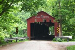 Great shot. Looks like a truck or two underestimated height!
 -
Gallery - Old Us 36 Photos
Keep the Show on the Road! replied to mobilene's topic in General Discussion
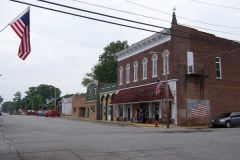
Jim, Enjoyed the gallery! It reminds me that there are really beautiful places to visit everywhere, so long as you stay on the old two laners! I liked the little town shot. I couldn't quite make out what the flag sign said. Keep em coming! Keep the Show on the Raod! -
Best American Road Songs - Poll
Keep the Show on the Road! replied to Jennifer's topic in Polls/Surveys
Good list! How about 10 Degrees and Getting Colder by Gordon Lightfoot under the Hitchhiking heading? He was standing by the highway With a sign that just said “Mother” When he heard a driver coming About a half a mile away And he held the sign up higher So no decent soul could miss it It was ten degrees or colder Down by Bolder Dam that day ..... Now he’s traded off his Martin But his troubles are not over For his feet are almost frozen And the sun is sinking low Won’t you listen to me brother If you ever loved your Mother Please pull of on the shoulder if you’re going Milwaukee way Its 10 degrees and getting colder Down by Bolder Dam today Keep the Show on the Road! -
Tetz Carriage Museum
Keep the Show on the Road! replied to Dave Reese's topic in Other Roadside Business / Attractions
You lucky son of a gun! Do me a favor and take a few road shots over the steering wheel and post them. If I can’t own one, at least I can pretend! I had a black 1958 MGA with wire wheels when I was in graduate school. I’d give a hundred bucks just to take one up through the gears. I have had at least three roadsters since and none compared. A few friends had TR3’s but they cost a bit more. As I said, you lucky son of a gun! Keep the Show on the Road! -
Tetz Carriage Museum
Keep the Show on the Road! replied to Dave Reese's topic in Other Roadside Business / Attractions
Dave, Thanks for sharing the trip. It is also nice to see what the area looks like in June! Sorry to learn the hearse is in regular use ! As an aside, how did you link to the gallery? I like the idea. Did you cut and paste the URL, or what? Keep the Show on the Road! -
Roadmavern, I think the experts were far too kind concerning the parts above that I contributed! There are plenty of exceptions to what I suggested, and I hope that I have avoided using words like “always “and “never.” There are certainly some amazing cuts that clearly break the “rules.” And I continue to try to find the one I once glimpsed from the freeway coming over Stagecoach Pass in Oregon. Terraserver, Google Earth, and now Microsoft Live Maps are nothing short of terrific as aids. The combination of modern high quality maps with high resolution color satellite imagery is beyond belief as a tool. Any and all additions and corrections are more than welcome, they are solicited.. The objective was, and continues to be, to gather here a collection of hints that can be restructured into a coherent guide for members trying to find and follow the old roads. Mobilene has offered to help make that happen. I want to throw in some map and road guide suggestions as well, and add illustrative photos as I get the time. Thanks for your interest and for helping make the oppportunity to share available via the forum. Keep the Show on the Road
-
Often, but I should have been clearer. What I was trying to do was identify those structures the old guide books typically used as “landmarks” or “controls” in giving their directions and distances. It was like “0.0 miles Starting at the bank..” ” or at “3.7 miles Pass school on the left” or at “8.2 miles Turn right with trolley.” Here is a typical early (1915) Northwest Automobile Blue Book page. Note the use of schools, hotels and garages as landmarks (and mail boxes on a tree!) to mark mileages and turns. Keep the Show on the Road!
-
I commented in a prior post in this thread concerning the more obvious roadside artifacts, e.g. old hotels, garages, service stations, and water fountains. I want to apologize in advance for this “stream of consciousness.” My purpose is to get some of this material out there so that it can be later organized and restructured into a better presentation for others to use. There is of course a whole class of structures that carried the road over or under something, such as bridges, underpasses, culverts, viaducts, etc. There is in fact a national bridge inventory site on the internet that attempts to identify, date, and describe each old road bridge in the country. As has been noted by RoadHound, bridges are often dated in the concrete or on a plaque attached to the bridge. The road is at least as old as the bridge, but roads often existed for a long time before streams were bridged, and older bridges were replaced with newer. Books have been written about bridges, no doubt several times over. A little different class of roadside artifact is the landmark cited in a route guide. It is a kick to follow a very old road using an old road guide that identifies turns by reference to a barn, a windmill, a schoolhouse, a spring, a tavern or a farmhouse. Occasionally the landmark still exists. Before roads were well signed (generally before the early to mid 1920’s), road guides were published that gave detailed descriptions of the road between two points. If you were setting off for a 100 mile drive between town X and town Y, you consulted your Automobile Blue Book, Mixers Guide, or Tib”s Guide. They gave you mileages between control points, or landmarks, and told you where to turn. They were quite exact and can often be followed even today. I intend to discuss them, and how to acquire them in a future post. I use the old automobile Blue Books often because old maps are not usually available with as much detail. Maybe some day there will be something called “old road orienteering!” If so, I claim charter membership. Banks, hotels, garages, post offices, railroad stations, and schoolhouses are the most common old landmarks cited in old road guides. Telephone lines and trolley lines were also frequently used to guide the traveler. In our area (western US) , and it may be true elsewhere, the old community bank was typically on a corner and the front had a 45 degree cut on the face of the building at the corner where the door enters. In fact, I know of no other class of old buildings that was so designed, so it is easy to spot the bank used as a road guide control point. Hotels were often the most prominent building in town. They seem today to be disproportionately large for the size of some of the towns you find them in. They are often multi storied and quite elaborate. One of the things we don’t always realize today is that the old hotel was the business center of the community as well as the place where people stayed. In a day when we do business via the internet we don’t often recognize the importance of the traveling salesman. His business was conducted at the old hotel, and they had rooms just for the display of his goods. Many old newspapers announced which salesmen were in town so that potential customers knew and could drop into the hotel to inspect the merchandise. Incidentally, the hotel and the garage to store your automobile went hand in hand, sometimes in the same building complex, but almost certainly nearby. Old train depots are among the most cherished and recognized old roadside landmarks. Today we seldom recognize the importance of the railroads as movers of people. As you follow the old roads using the old guides, railroad stations, often long gone, are frequently used as mileage markers . Railroad stations aren’t difficult to spot. Even when the buildings are gone, the large cleared area beside the track or abandoned track bed with foundations or other remnants is not too difficult to identify. And what we call a railroad with its steam engines was not the only rail user. The interurban line with big trolley or streetcar type vehicles was the lifeline of many communities and often went for many miles into the countryside, connecting a bigger city with many smaller towns. Both the rail line and the stations are old landmarks in the guides. School houses are among the more charming landmarks along the old road, and it least in the west you can add old Grange buildings to the list of prominent landmarks. Both represent a day when our population was predominately rural. School houses and granges are frequently set all by themselves in an otherwise vacant area. Sometimes the old outhouse survives as well. There are books that describe the old one room school and I can’t imagine that anyone has much problem recognizing a schoolhouse, often with its bell tower. Churches may be mistaken occasionally for a school house and vice versa, but my experience suggests that churches were more often in town and the one room schoolhouse more often alone in the countryside. The general mercantile store is another category of old road landmark at least in the west. It was common for a mercantile store to be situated at a crossroads, or of course in a town. At least in the west they often followed in appearance the stereotypical false front style. I know of perhaps a dozen that are still in business in some pretty quiet places, but one by one they are disappearing. We don’t have diners often in the west, but clearly they are another important category of roadside artifact, which I hope someone more familiar with them will describe. I realize there are several varieties, but a description is beyond my “expertise.” In a few small towns in the west, there are stone pillars, occasionally crowned with a ball or lamp, that sit on each side of the old road’s entrance to the town. I have even seen them in the middle of a vacant field, telling me that the old road once traveled that way. It is common for the name of the town or the word “Welcome” to be written in smaller stones in the pillars. I’m sure it is getting a little “specialized” to consider guard rails as roadside artifacts that help identify an old road, but they are a part of the built environment along the old road. In the northwest the most common old guard rails are of three types, round cement posts, rectangular wooden posts with mitered tops, and fence like barriers with two or three flat board rails secured to posts. The first two are connected with cables that are held in place with U clamps. Remnants of weathered yellow, white, or black paint adhere to the old barriers. In Oregon the old Columbia River Highway, built in about 1916 has lovely rock walls as barriers, and the same design is found on the old Pacific Highway (old US 99) near Oregon City, leading me to think they are of similar age. An important artifact identified with the old road I want to mention here is the old sign. There are several types, from billboards down to US highway shields and painted auto trail markers. Most old road markers or direction signs don’t exist today outside museums or collections, but very rarely you find one “in the wild.” I included three in my Yellowstone Trail posts here that I saw in eastern Washington recently. A more likely to see sign is on a building, above the height someone could pull it off or paint over it easily. In towns along almost any old road, look up at the sides of old brick buildings. They were the early billboards. The signs may identify the business, or as is often the case advertise cigars, beverages, farm implements, men’s coveralls, or automobiles. And I almost forgot the patent medicine ads on old barns. Look at my recent Yellowstone Trail posts again for one near Waterville, Washington. More coming, and I will add photos as time permits. In the meantime, Keep the Show on the Road!