


Keep the Show on the Road!
-
Posts
2,829 -
Joined
-
Last visited
-
Days Won
26
Content Type
Profiles
Forums
Gallery
Blogs
Calendar
Everything posted by Keep the Show on the Road!
-
 This is off topic, but worth noting. The men and women who were involved in D Day on the ground, on the water, or in the sky deserve our respect and appreciation. I have much of the memorabilia from Major Thomas Dale Hutchinson who was a wing commanded and later deputy commander of the 384th, including his pilot's logs, crew photos from his flights, and even some actual pre flight briefings for bomb raids over Nazi Germany. You can’t see and read such first hand materials without recognizing the day to day sacrifice those guys made routinely. And many didn’t come home. That’s the rest of the story behind Keep the Show on the Road.
 -
Thanks Becky! You always make it worthwhile! And we are having fun besides. Roadside artifacts as I call them, or roadside architecture as it is often called is fun to discover and identify. Heritage travel, and perhaps a kind of nostalgia for the old days of splendor and perhaps excess has prompted the renovation of many old hotels. Under Lodging I just posted a 1913 photo of the French Lick Springs Hotel because its renovation and reopening is a current topic here. The hotel is a good example of a renovated classic old road hotel. There are many more. Not all the old hotels are quite as easy to identify, but if you enjoy old post cards or have some of the old touring guides, it is fun to do a then and now thing. When I know I’m going to new territory by road, I try to check my references; my post cards of old hotels, Automobile Blue Books, and other guides. Then when I get into town I compare building facades and window and door placement against the old photos. Look above the street level because the sidewalk level building face was often completely changed over the years to accommodate new businesses and styles. When you do look up, see if you can spot the old radio antenna poles. Remember before there was cable, there were rooftop TV antennas, and before TV antennas, there were radio antennas strung as wires between poles on the roof. I check the position and style of windows and the shape of the crown on the old building. Garages are one special group of old roadside buildings because there are so closely tied to road travel. They are often treasured by old road groups, (eg the Altamont Garage in the Tracy, California area by Lincoln Highway Association members) and it is always fun to identify one that has a name in some historical reference. I spotted the Model Garage in Rosalia, Washington along the old Yellowstone Trail a few weeks ago and photographed it for one of my Yellowstone Trail posts. Old garages are among the most evident roadside artifacts because they had to have big doors, just as did their predecessors, stables. Many old garages survive in other forms today, perhaps in part because they often had wide, tall window openings along the front which later were useful in merchandising. So look for often one story buildings with big wide doors and large windows facing the street. The Rosalia example has another sure give away, and that is the metal or concrete bumpers at each door edge to protect against drivers with poor aim. Old service stations are fairly easy to spot because they had a pull through for the cars. Many styles exist, and I will attempt to post photos of a few prototypical examples Of course the earliest “stations” were hardware stores where gasoline was sold by the 5 gallon tin. And later it was dispensed from a wagon or cart that the seller rolled to the customer’s car. Not much is left of these examples, but a photo of the latter will follow as soon as I can scan and post it. Water fountains were a special class of roadside structures and were actually the subject of design attention in the 1920’s and 30’s. The old fountain was often made of stone, and usually was found on a long grade where old cars suffered boiling radiators and vapor lock. Vapor lock occurred when the engine compartment got very hot on the grade and the metal tubes carrying gasoline heated up enough to cause the gasoline in them to boil. Then the mechanical fuel pump couldn’t pump the gasoline to the carburetor because it was a vapor, not a liquid. On a very hot day you were cautious not to stop on asphalt as the black surface had absorbed the heat and would cause the gas in the fuel lines under the car to also boil. The solution to vapor lock or a boiling radiator was cold water, splashed on the gas lines, or poured over the radiator honeycomb before you released the cap. The unused fountains today are often in small groves of trees that were watered by the constantly running water. Of course they are located at a wide spot where it was possible to turn off the road. A few today still offer their sweet, cooling water. Lots more roadside artifact hints to follow so Keep the Show on the Road and add your insights!
-
French Lick Springs Hotel Reopening
Keep the Show on the Road! replied to roadmaven's topic in Lodging
I imagine there is a book somewhere that uses the name French Lick in its many possible contexts, and your observations have only whetted my appetite for more.! But before Mom and Dad step in here and remind me of the rules, I want to add an item that might be of interest. Is this the French Lick Hotel of which you speak, and who or what is Pluto? This comes from a 1913 Automobile Blue Book. The numbers on the map are route numbers, not mileage. On request I will scan the detailed route descriptions, if anyone wants one or more. Keep the Show on the Road! -
Every one a gem! And all apply in my experience in the west, not just to Indiana. I like the idea of illustrating each with photos. Let’s keep em coming. We are getting some good advice. I will add some related stuff as I get time. The satillite maps are really valuable. Google Earth is outstanding where they have the maps at high resolution. The 3D really helps! Microsoft’s TerraServer also does a good job in B&W and has more maps at high resolution (although Google’s 3D color maps are catching up in the coverage category.) Whether you use an on line map site like Google or a CD like Delorme’s Topos (which I find excellent), maps that show the terrain in 3D are very useful. Once you see the grades you can invariably pick out the logical main road route from among lots of offshoots and crossroads. The older road followed the easiest grade. It did not climb over ridges or cross canyons it could avoid. A ridge or canyon is tough to identify on a standard 2D map, but in 3D you know immediately which is the logical route. Keep the Show on the Road!
-
Another good one! Thanks Roadhound. I am starting to dig deeper now to remember how to identify the older road on the ground. It seems in my memory that most of the time I’m looking down from the new road to the old. Maybe that’s because I’m driving a car without a sunroof and I can’t convince Sheila, Rose of the Road we need a convertible! But my experience tells me that coming up a canyon the old road will tend to stay nearer the creek bottom, and perhaps make a shorter, steeper climb at the end or head of the canyon. I can see the engineer saying should I try to grade and build shelves all the way up this canyon or weave around the big rocks in the bottom with minimal earth moving and make a final grade at the end. Where there are two choices, I usually find the concrete road to be older than the asphalt road. I don’t know why, but I do know that the concrete people advertised like mad in the teens and into the 20’s. Concrete roads were a huge improvement and strongly promoted by such as the Lincoln highway Association. Maybe later, say in the 1940’s asphalt construction and maintenance costs maybe were lower. When I see a concrete road with the expansion joints, and perhaps rounded gutters, it is always older than its asphalt companion Going through towns, RoadDog has already identified Main Street as the most likely candidate for the old road. Of course 1st, Adams, and Pioneer are also contenders. And when following a named road like the Pacific Highway (old US99) a street called Pacific is a big hint! Big stately trees on both sides of the road are associated with the old road. If the road has been widened, there may be only one line of trees. Look for obviously planted lines of trees. The older road went down further in the canyon to cross the creek, so that the bridge would be shorter. When you cross a wonderful 1930’s or 40’s high arched bridge, pull off at either end and look down in the canyon. Odds are fairly good you will see a riverside road that crosses the water on a short older bridge. Old cars needed water for their radiators, and a boiling radiator was almost an expectation on a long grade when fans were belt driven (not run by electric motors). Thus the water fountain is dead giveaway on old roads on a grade. BTY we need a book on the old water fountains, if it hasn't been done. Keep the Show on the Road!
-
Helpful!! Usually Main Street, while the road beside the railroad was Front Street if it didn't have railraod in its name. Thanks RoadDod! I appreciate it! And Keep the Show on the Road!
-
Invasion of Normandy, or in other words, D-Day. Thanks for the reminder! Keep the Show on the Road was the motto of the 384th Heavy Bomb Group of B-17s flyimg out of Grafton Underwood, England .
-
A couple of us want to invite all of us to share how we discover and recognize what I have called here “old road treasures.” Treasures include first the old road itself, its former paths and routes, in short its former alignments. Treasures also includes built roadside artifacts, for example an old fountain for filling your radiator or even an old abandoned service station, or a dugway where the road crossed a creek. When we have your insights together mobilene has promised to compile them into a coherent whole for all of us to use and enjoy. So I will start it off with a few ways I recognize an old alignment The old telephone lines followed the old road and didn’t move when the road was later realigned. Watch especially for posts with old ceramic or glass insulators, but follow the posts. Figure the old road followed around a wetland or stream just above the high water mark, so look for a flat but curvy bed at about where you think the water reached its highest mark in winter. The old road followed the old rail line if it could, to avoid grades. It often crossed and recrossed the rails to make it through narrow places. The old road followed on the old rail bed if it was abandoned (and often across the old rail bridge, abandoned or not!). A corollary to the above is that a very flat roadbed with no grades isn’t usually a highway bed but rather a railroad bed. Rail beds were often filled to a foot or more above the surrounding terrain to provide a flat and dry base. Few early auto roads enjoyed such an investment. And anytime you approach a cut or fill, look left or right because the old road went around, not across or through. Look on slopes for retaining walls of stacked rock or sometimes concrete. Because they didn't have bulldozers to cut in, they built out from the hill. (Look at my Yellowstone Trail post for a vintage "earth mover "of about 1915 and you see why.) Obviously the trees and shrubs will usually be shorter in the old road bed, so if you look into a line of woods you can often spot the break in the tree line where the old road entered the woods. In the desert I look for two parallel lines of sun blackened rock in the sand maybe 15 feet apart. They were either lightly graded from the road, or tossed out by traffic. Look for rusted tin cans with soldered tops (drop of solder in the middle). They were tossed out many years ago along the old road. I guess it is also self evident but the old road curves more, makes abrupt turns, and follows the contours on a grade. In farm country, the old road followed the section lines and never ran across a farmer’s prime land. Look for the road that jogs left and right, It is older than a straight road through farm country. The old roads connected towns and farms with towns, so the town wasn’t bypassed by the old road. The bypass isn’t the old road. On a long grade, the old road is the less steep and the more winding. The old road generally doesn’t sacrifice altitude needlessly. Said another way, it doesn’t gain and lose altitude repeatedly to shorten distance or maintain a straighter alignment. Said yet another way, it will go a longer distance to avoid grades or having to reclaim a height it has already achieved. That’s a start. More to follow. Please Jump in with your insights. Keep the Show on the Road!
-
Welcome - Please Introduce Yourself!
Keep the Show on the Road! replied to Jennifer's topic in General Discussion
Right, the telephone poles didn't move when the road did! This could be fun, and I want to get these things on paper before my memory goes! I also want to make some suggestions on where to find or acquire maps and the like. And how do you find out where the old road went if you don't have a map. I don't see why you couldn't replicate the stuff on your website, but you might check our Rules. Sometimes forums claim the copyright on anything posted on the site. I don't think this one does, but it wouldn't hurt to check the rules. I want to include finding the old road treasures as well. By treasures I mean the evident and not so evident artifacts like the old buildings and other remnants of highways past. There isn’t a clear place to start this thread, so I guess I will post under General Discussion. Pat or Jennifer may move it if they have a better category. Keep the Show on the Road! -
Welcome - Please Introduce Yourself!
Keep the Show on the Road! replied to Jennifer's topic in General Discussion
Jim, Your work is entertaining and informative! I guess intelligence and competence count! I have been following old alignments for 25 years and you as a relative newbie have already eclipsed my “talent!” You did a splendid job on your write ups so I know you are a serious aficionado. Keep em coming! I have a collection that is pretty good with at least a few thousand maps and guides I use to track old roads and roadside artifacts and architecture. It is mostly western US but not to the exclusion of other areas. I also have developed a nose for the old alignments that comes out of lots of experience, but which I think might be described usefully for others. I have thought from time to time that I would offer some “insights” about finding and following the old alignments and understanding what to look for in recognizing the old roads. You have the talent and knowledge, and I may have a bit more experience (maybe not) so perhaps we could combine our “advantages” to the benefit of others on the forum. And other folks here who will photograph an old concrete highway gutter or follow the old road through the sagebrush may want to add their knowledge. Then you, as both knowledgeable in the subject and skilled in the communication arts, might pull it all together into an organized and lucid whole for all of us to enjoy. What say ye? If you are interested, I’ll start a new thread to invite members to share their insights. Keep the Show on the Road Peace, jim -
Welcome - Please Introduce Yourself!
Keep the Show on the Road! replied to Jennifer's topic in General Discussion
Jim, Your ears must be ringing. We were talking about your site in glowing terms this evening on a chat. Those write ups and pictures define the genre! Incidentally, I like your map comparisons in the first post. Being a map guy myself, you made an interesting use of maps from different periods. I'm going to take a look at a 1920's map of the same area and see what it holds of interest. Maybe throw in a couple of links (highlight the link and click the tree icon to have the image display in line) to a photo or two of yours in your next post so viewers are encouraged to stop and take a closer look at your work. You are helping Keep the Show on the Road! -
Welcome - Please Introduce Yourself!
Keep the Show on the Road! replied to Jennifer's topic in General Discussion
I know of a couple of us from the state of Washington who post here. I live in Olympia. I lived for a while ten years ago in Snohomish, so I know the Lake Stevens area a little. We need more active members from Washington as I am holding out against the rest of the country practically by myself. Welcome!! I haven’t had much to do with ham radio for many years and back then it was with a friend who was a ham. I have often thought it would be fun to get a metal detector and scout out a few places. We were along the Yellowstone Trail (now US 2) between Waterville and Coulee City (in Moses Coulee) a few weeks ago on an abandoned alignment and I wondered if I could find some mementos of its earlier years. One of my 1920 maps showed the site of a long forgotten hotel in the Coulee itself, and I thought it would be interesting to do a little “treasure hunting” We located the probably site, but a metal detector might have found something to confirm it. Not to lead the topic astray, but any advice or luck finding anything significant along an old road? Is there a compact metal detector? As it is I have my laptop, GPS, maps, cameras and dog (and sometimes my wife!). I remember another time when it would have been fun. Frenchman’s was a well known stop (Hotel, service station) on the Lincoln Highway back in the 1920’s, but the site today is just a few bent pipes. It would have been kind of interesting to find a 1920’s coin on the site. But alas, I wasn’t equipped, so all I could identify was what looked like a broken arm off a vintage shock absorber. If you are taking a cross country trip, can you post a running account for us to follow? The thread would be fun and we could track your progress. Besides you will get more advice than you can possible use on what to see and where to stop. Incidentally, I have a detailed 1912 atlas of snohomish County that might be useful in treasuer hunting. It's not for sale, but if you have a specific area that you would like more on, perhaps I cpould copy some for you. Let’s Keep the Show on the Road! -
We have been commiserating lately about the increase in gasoline prices, but who recalls the long lines at service stations and the alternate sale days of the early 1970’s, or the outright rationing of WWII? In the early 70’s (73-74) there was a period when you were limited to how many gallons the station would sell you (10 was the typical number in my area) and the station may have been open only part of the week, most typically alternating days. And does anyone remember from first hand experience the rationing of gasoline and rubber in WWII? I was a little young to remember myself, but I have some ration books I keep around for history’s sake. Let’s Keep the Show on the Road
-
Welcome - Please Introduce Yourself!
Keep the Show on the Road! replied to Jennifer's topic in General Discussion
Wow, Jim. your blog is, as my son would say, "Awesome." I look foward to knowing when your hosting company gets squared away so we can see more And thanks for a great post. I look forward to more! Welcome aboard! Keep the Show on the Road -
Keen eye! Right, and multiply the 1906 price by maybe 20 (or more) to get the inflation adjusted cost. I guess if you could afford a car in 1906, you could afford a $100 set of maps. Thanks for the observations! Keep the Show on the Road
-
You are right, the 10 MPH, eyeball to eyeball level does make a difference. Before I was an auto road tripper, I was a bicycle road tripper. I met more people, got invited to dinner more often, and saw more on a bicycle. Kind of like the difference between a two lane road and the interstate. But I was a lot younger, and even then I got tired of idiots throwing things at me as they drove by. I don’t think they really recognized that a beer bottle travels at 65 MPH if the drunk throwing it is in a car going 65 MPH. I look forward to seeing the movie. Thanks for the tip. Keep the Show on the Road
-
Ah, Denny, you reveal yet another talent, as film critic! A very good write up! It is always good to know you have a fallback, or a second income if you ever need it! Kidding aside, I like your comparison with the Pony Express! They changed horses, and the Segways changed batteries. It is almost a (what is the term?!) for the old and the new! Beyond the fact that it could be done, I don’t see many people selling their cars and hitting the road on Segways! Although some of those little scooter cars aren’t much bigger. Thanks for sharing! I added it to my Netflix list. Segways help Keep the Show on the Road!
-
Pat, A good bit of information. In summary, the gas stations aren’t making the money, the price of crude is not that much higher, and the oil producers who are suffering from all the “regulations” and “production problems” are making the biggest profits in all of corporate history. If you were president of an oil company and your profits skyrocketed when demand was high and production was restricted, would you build new capacity with your profits? Not if you wanted to keep your multimillion dollar salary! I’m just a dummy. but even I know what makes the world go round. This is a closed market. New companies don’t enter the market and compete with the existing companies to drive prices down. There has not been a new oil refinery built in 30 years (says the article). The big boys don’t have to sit around a table and fix prices, they all know what is in their best interest. Here is the simple truth. We will pay whatever the price at the pump, and forego something else so we can drive (including me). We have even said in surveys that we won’t change our demand until prices approach $5.00 a gallon. The oil companies know that. In the long run we will acquire more fuel efficient vehicles and high prices at the pump will make alternative sources of energy to move our vehicles more viable. We could be enjoying some interesting changes in vehicles over the next decade. I’m already noticing those little scooter cars on our streets. (Does anyone remember the Crosley?) But for now, count on more of the same. Would someone please tell me I’m wrong and explain why. Keep the Show on the Road
-
Old Road Maps & Travel Graphics
Keep the Show on the Road! added images to a gallery album in Member's Gallery
Travel Graphics from the Old days! -
-
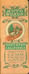
Gray's 1906 Southern California Travel guide
Keep the Show on the Road! posted a gallery image in Member's Gallery
From the album: Old Road Maps & Travel Graphics
This is the oldest set of California road maps you will probably ever see. The cover reflects the more restrained graphics of the turn of the last century. -
From the album: Old Road Maps & Travel Graphics
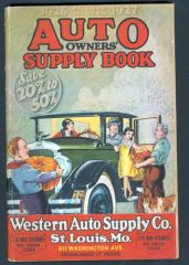
Western Auto was a major auto supply retailer in many towns. The family theme with either the grandparents as farmers, or the roadside fruit vendor, were common, as America was still primarily a rural society. -
From the album: Old Road Maps & Travel Graphics
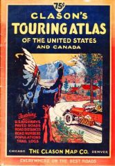
The Native American image appeared regularly on maps and travel materials in te 1920's, both road and rail -
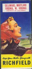
Richfield Traveling Girl, 1937
Keep the Show on the Road! posted a gallery image in Member's Gallery
From the album: Old Road Maps & Travel Graphics
Ah, the top's down and the breeze is sweet. A nice graphic from the late 1930's as the country gradually comes out of the depression, car sales are climbing, and things are a bitt better. -
Richfield Strip Maps and Grade Guide Ca. 1937-38
Keep the Show on the Road! posted a gallery image in Member's Gallery
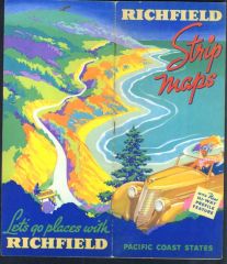
From the album: Old Road Maps & Travel Graphics
Looks like an idealized view of California 1 along the coast or perhaps the Oregn coast. -
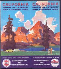
From the album: Old Road Maps & Travel Graphics
Typical Chevron graphics for the period. This is a 1946 map, published just after WWII as travel was again possible for Americans.