


DaleS
-
Posts
140 -
Joined
-
Last visited
Content Type
Profiles
Forums
Gallery
Blogs
Calendar
Posts posted by DaleS
-
-
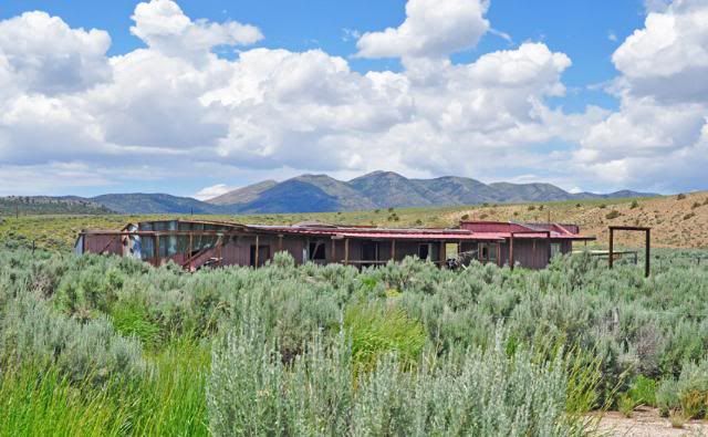
A picture from the new highway 50 shows the building much better:
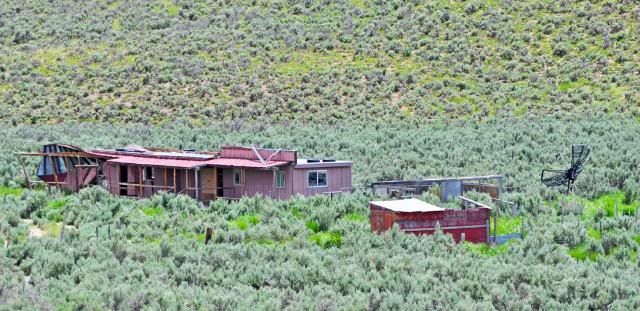
Making all these pictures and getting them ready to post is why I can't look up all the stories, Dave & Denneys job.
Dale
-
I am camped about 6-7 miles west of Ely, Nevada at Egan Crest Trails. There is about a mile or two of old 50 the ends here. On my way
back from Ely I took this section of road today.
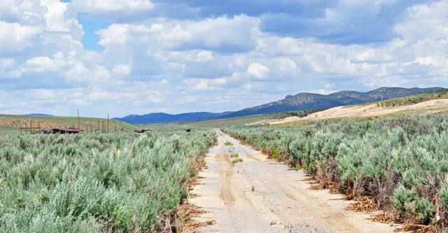
I had been passing this piece of hwy for many years and always noticed this failed business.
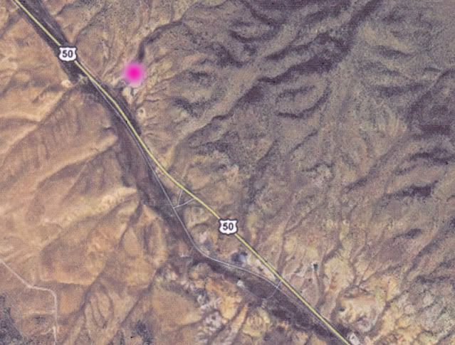
Here is a Google Earth link to where I am at and you can see the road south of me. The pink spot in the
upper left corner is where I am now. The pink spot is at 39.31150 114.99006.
Dale
-
This morning I parked in front of the courthouse in Eureka, Nevada to have breakfast in the Owl Club Cafe. On the way back
I noticed this plaque.
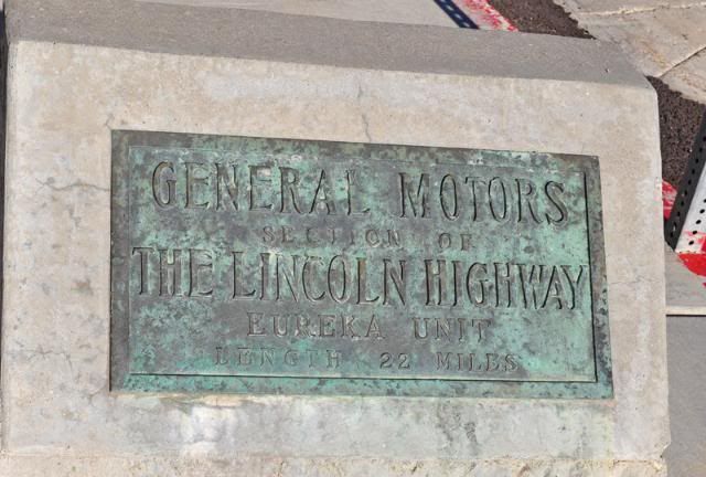
This is what I found out for it in a quick search.
General Motors Marker, 1919, US 50. The marker commemorates the 22 mile section of the Lincoln Highway constructed with funds donated by General Motors corporation. The marker’s plaque reads, “General Motor's Section of the Lincoln Highway, Eureka Unit, Length 22 Miles.”
I can only run a computer during daylight hours, living on solar.
Dale
-
I used to have an Nikon F camera and lens also. Digital is so much easier to do now. No film to buy, no waiting for developing, no worring about
light. Get a $100 Photoshop and fix it all. I have taken 500 shots a day sometimes and get a couple. Other times (Osprey) 6 good ones in a second.
looking to camping near Schellbourne, NV and check that area out.
This is a good site about Pony Express station is Nevada:
http://www.xphomestation.com/nvsta.html
Dale
-
One more thing, most the time I only get one picture out of a hunderd. Sometimes I get lucky.
Not many birds here at Spencers hot springs. Hope to get pictures of Nighthawks flying at Illipah Res. next week.
Dale
-
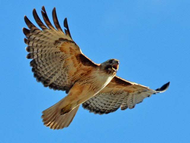
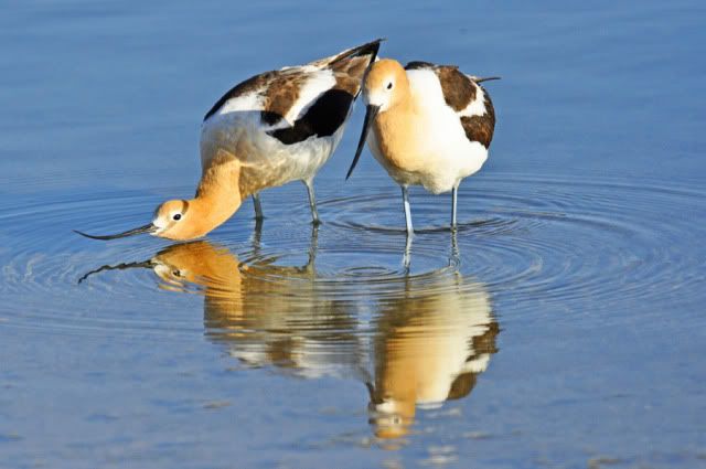
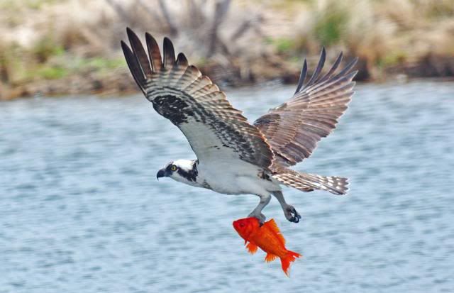
Those two bird pictures were taken in May of this year at Fish Lake Valley Hot Springs near Dyer, NV. That female? osprey
would come in every other day and get a couple goldfish. I was parked close to pond that the osprey would come to.
When the avocets started flying I knew the osprey would be coming in and I would jump out of the rv, ready to take pictures.
I use a Nikon D7000 that takes seven pictures a second with a 80-400 mm lens.
A few more for you:
This redtail hawk didn't like me getting close to pole where her almost grown chicks were in June:
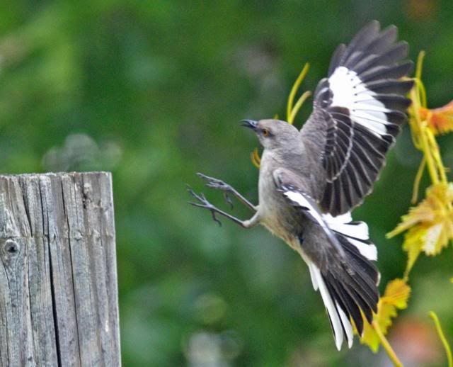
A mocking bird in a yard I was staying at in May.
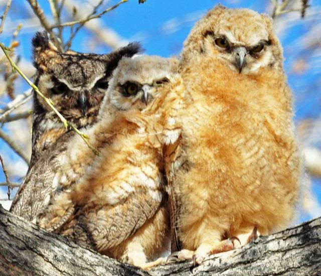
My wife saw the backs of these Horned Owl chicks at Wilson Cayone south of Yerington, NV and thought
they were monkeys.
I hope you enjoy these pictures.
Thanks again Dave for telling how to post pictures.
In a week or so I should be north of Ely and finally and send in some reports on Old Lincoln Hwy & Pony Express Trail between
Utah border and Egan Canyon.
Dale
-
Denny, if you Google Earth Spencers Hot Springs, there will be pictures of it. About 6 miles north
is Cape Horn Stage station, it should on GE also. Then you can scroll northwest to Simpson Park Canyon.
It was a long trip for you to come out here.
Dale
-
Dale, I was in Austin on the 19th and I bet you were somewhere nearby. I didn't have a 'burger at the International (I'd just had lunch up the road at DJ's) but I did have a beer and learned about Genghis Khan.
Hey Denny, I was in Oregon then, I got here on June 27th. I'm about 20 miles east of Austin at Spencers Hot Springs. It is a neat place to
camp out here, warm water to do dishes with. Nice to have a soak at sunrise and sunset.
You should of had a 1/2 lb burger at the International, it takes me two beers to finish one.
I just found out how to do the "quote". Blew it on the Cape Horn reply.
Dale
-
Denny wrote:
DennyG, on 08 July 2011 - 06:33 AM, said:
Wonderful stuff! I was on some of the Pony Express route myself a couple of weeks ago but nothing like that.
Dave: Any luck with Burton? I took a look but it seems he mentions no station between Simpson Park (which I'm guessing is somewhere around Eureka) and Reese River Valley (which is a bit west of Austin). Since that's a distance of 50 miles or more I'm thinking there must have been another station but I didn't see a mention of it.
------------------------------------------------------------------------------------------------------------------------------------------------------------
Going west from Cape Horn Station is the Simpson Park Station, it isn't near Eureka. After going across the flats from Cape Horn station the trail goes
up Simpson Park Canyon. The Simpson Park station is in the next valley, trail then went north of Austin to the Reese River station.
Dale
-
Simpson Park is the the west of the last picture I took with all the brush. It is 6 miles Northeast by east from
Austin. Just over the mountain east of Austin on Hwy 50 and north in the next valley.
http://www.xphomestation.com/nvsta-simpsonpark.html
I read yesterday that the Overland Stage used a Pony Express station at Reese River
until Austin beacame a town in the early to mid 1860's. Then the station was moved to the International Hotel.
Some other reading about the Overland Stage Route.
http://www.lahontanvalleynews.com/article/20100821/NEWS/100829971
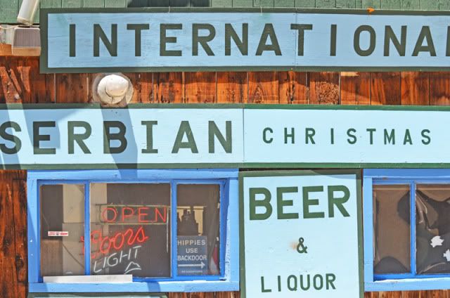
While in Austin today (having a cheesburger) I took this picture of the International Bar. Notice the blue sign that says
"Hippies Use Back Door".
I would like to share a couple other of my photos.
(off topic) A pair of Avocets, the one with the curved bill is the female
An Osprey
Thanks for looking, Dale
-
Thanks for both of you liking my pictures, I used a little cheap camera that I ride with, not my good camera.
Photoshop helped.
Dave, I had a cheesburger at the International Cafe for you yesterday.
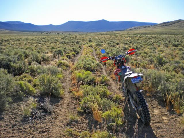
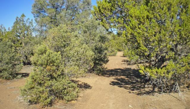
This morning I took a ride on the Pony Express Trail west of the sign.
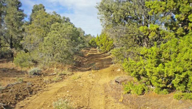
After a few miles the trail closed in:
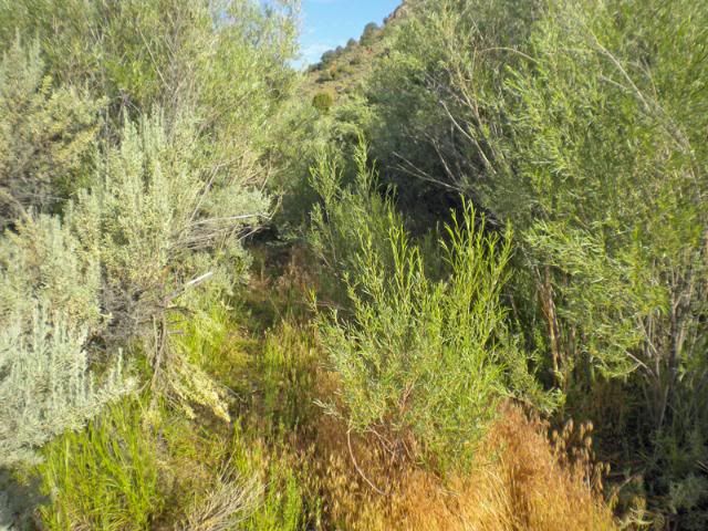
No long after that there was a creek crossing that didn't want to try being by myself.
Dale
-
Sixteen and a half miles east of Austin, Nevada is Cape Horn. Not much to look at:
Taken at 39 23.268 116 50.869
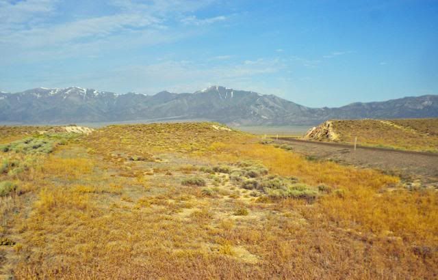
Showing the present and a past road cut at Cape Horn.
To the North about 1/2 miles is where the Overland Stage Route crossed Cape Horn. There is about a mile of
the original trail left. It starts off Hwy 50 at 39 23.391 116 50.584
Google Earth shows about 3 miles of the trail going northwest of the station, but I
couldn't find it on my dirt bike. There were sand washes on either end of it.
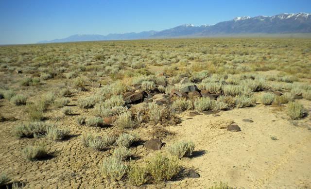
On the west side of Cape Horn about a mile north of the present Hwy 50 is where the Cape Horn
Stage Station was. All I could find was this pile of rocks that may have been part of the stage
station. 39 24.009 116 51.283
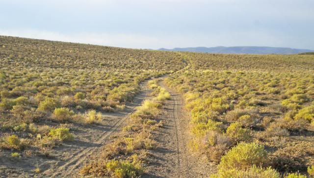
Now the oldest route is the Pony Express Trail. It is about 5 to 10 miles north of Hwy 50.
This sign is at 39 29.493 116 52.400
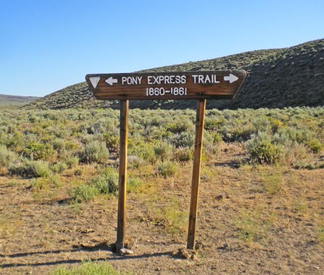
Standing in front of the sign, to the right is east. 50' to the right this picture was taken, the trail is
this cow path.
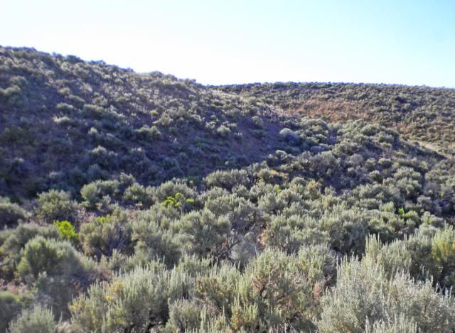
Farther to the east this picture was taken
About 5 miles from the sign the trail looked like this,
Not long after that I lost the trail at 39 30.949 116 48.216
Dale
-
I would think not knowing that the Midland Trail would be near US 6 going from Ely to Tonopah in Nevada.
I just bought a hard cover copy of the Midland trail from Amazon $10.
I went from Tonopah to Ely in 1979 and plan on doing it again this year in late Aug.
Dale
-
Dale,
Good to see your post! But it sounds like the bill remains "safe!"


Dave
Keep the Show on the Road!
I saw where you took the picture you posted, that was like the old one when the highway was in use. If that is
where the $1 bill is, you can keep the $20.
If it was at an easy place, I would take a picture of it and let someone else find it. Was I geo cache, I want a salmon or crabs.
Dale
-
Thanks for the photo posting info. I have an account at Photobucket.
I was too early for lunch today at the International Cafe, but have had some nice breakfasts there. They
always have nice help.
There used to be another establishment a Sand Springs many years ago. The kind of place you can't take
your wife.
Stay away from that basement, sell it and get a motorhome.he he
Dale
-
Sorry I didn't check in sooner, Dave.
I'm sitting off Hwy 50 east of Austin at Spencers Hot Spings.
Planning on checking out Cape Horn Overland Stage Station in a fews day. Too bad I can't
post any more pictures. Maybe I can post a link?
Dale
-
Hey Dave, I drove up Golconda Summit Monday morning and was thinking of your $1 bill.
Dale
-
Very sad indead.
In 2002 there was a shoe tree, hat tree and a bra & pantie north of Quartzsite, AZ. I got a picture of it and next time
I went by, and few days later they were all gone. I did have a picture.
Dale
-
SPOT should run about $100 and sometimes a $50 rebate. The service with tracking is $150 a year. It sends
out a message of your location ever ten minutes, which can be seen on the internet. You can send a message,
"I'm OK" "Help" to an email address or a text message to phone. Also you can call 911 and they will know
who to get ahold of for you. When you buy it you can get a "rescue insurance" for like $8 or $9 a year.
My maps (which are not as good as Dave's) shows the Lincoln Hiway north of Ely following the Pony Express route
and going across the desert in what is a closed area now.
Dale
-
I remember riding in the back seat of a 35 Chev, going through Fairfield, CA long ago. As you were leaving town east bound
there was a Millers Beer sign. It said the "Champagne of Bottled Beer".
A couple weeks ago I took Hwy 40 though most of Utah. It is a very good road now, not the old one in most places.
-
Hey Dave,
I talked to my friend who goes to Middlegate a lot.
He told me the the Navy bought Frenchmans a few year ago because it was
close to the bombing range and were afraid of it getting bombed.
Dale
-
Isn't the bar at Frechman's still there? Friends of mine would drink there with AF pilots
when they were M/C riding in the area. I remember Frenchman's in the 80's. I'll
see a friend that know all about the area soon and ask him about it.
Near Sand Mountain at Salt Wells there was a cat house.
-
Hey Dave,
I just remembered a trip I took across Nevada in 1964. I had a WWII 4x4 army ambulance. Drove north of Hwy 40
on dirt roads to Elko, dropped down to Eureka and headed back on old Hwy 50. Started out with two spare tires, near
Austin I had the third flat. Driving down Hwy 50 with a flat front tire, I drove by this gas station knowing they wouldn't have
a tire to fit the rig. Drove into Fallon on the rim and got a tire to make back to California.
So it was open in 1964.
I will be going by there the first week of next month.
Dale
-
What a shame, I remember driving up White Rock Road though Clarksville and getting on old Hwy 50 there
when it was a two lane road.
A little bit of old history on Clarksville, from the Sacramento Bee years ago. Tales of the Old West told of a
sheriff of Clarksville who was getting hard of seeing, who wanted to keep his job. There was a bank robbery
and he shot his own son.
Dale
Cape Horn In Nevada
in Lincoln Highway / U.S. 30 / U.S. 50
Posted
Thanks Denney, very interesting. Cape horn is a low hill with kind of the shape. The stage route should have changed
some after discovering silver in Austin.
Dale