


mobilene
-
Posts
1,247 -
Joined
-
Last visited
-
Days Won
1
Content Type
Profiles
Forums
Gallery
Blogs
Calendar
Posts posted by mobilene
-
-
Nope, correction, I read my ABB wrong. 1.4 miles does put you right at Lower Dillsboro Rd. Dillsboro ("fork at bank") is at 10.2 miles per Google Maps, and my 1924 ABB says 10.1. Drat! I hate it when I miss an old alignment! If it didn't take me 2 hours to get back there I'd pick it up on my next trip.
I still think Indiana/Tresler Hill was the next alignment of 50, before the current one.
-
Hey, thanks Denny for the 1927 ABB snippet. Very helpful. My 1924 ABB, now that I've thought to check it, gives a similar route for Old SR 4 -- Main to 3rd, right on 3rd till it ends, left and next right and follow Highway No. 4. 1.4 miles later, it says "4 cor.; left." 1.4 miles is about .3 miles past Lower Dillsboro Rd., but it looks like the intersection with Lower Dillsboro Rd. would have been a 4-corners back in the day. 1.4 miles, in contrast, falls right where Indiana Ave. peters out into the fill for current US 50 -- no 4-corners in sight. But now my Spidey sense is tingling that Lower Dillsboro Rd. could have been the old alignment. It makes sense, even if the mileages don't add up. I wish I had driven it anyway.
My guess was that 50 turned briefly south where Lower Dillsboro Rd. begins, following Indiana Ave. It looks to me like Trester Hill Ave. follows that general line, as well, past where Indiana Ave. ends at current 50. It was Trester Hill Ave. that didn't look too friendly to me.
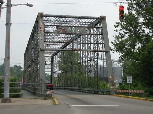
The old bridge, by the way, was US 50 until 1950 and SR 56 until 1972, according to this site.
Thanks for the link about Hillforest!
-
Denny, thanks for filling in the blanks on Beer's! I didn't realize there were more signs inside!
I'm actually quite introverted and am not the type to walk into a business and ask questions about the place. Matter of fact, when I photograph something like this, I try to be quick and inconspicuous, especially if I'm standing on the property itself rather than in the road right-of-way. I've met some proprietors who've wondered what the heck I was doing, and while it's never been a bad experience, I generally prefer to be left alone!
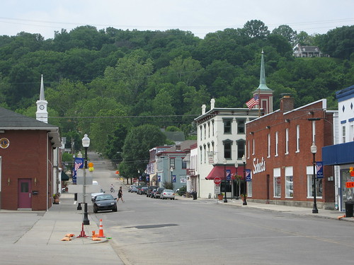
Aurora was my favorite stop on this trip. I spent a lot of time there taking pictures. I got hungry, so I injected about $7 into the local economy at a Mexican restaurant. I was more in the mood for a cheeseburger, but Mexican was what I found, so it was what I ate.
Not long ago I bought a DVD from this fellow on eBay of old Indiana maps from the mid 1800s to about 1940, and it was the best $5 I've spent in a long time. Maps from the 10s and 20s suggest (as best as state maps can) that US 50 and its predecessor, the original Indiana State Road 4, went through Aurora over this 1887 bridge, still in service.
This is the old road as it passed through Aurora westbound. The business district is actually on a perpendicular road. Some nice architecture there; click through to see those photos on Flickr.
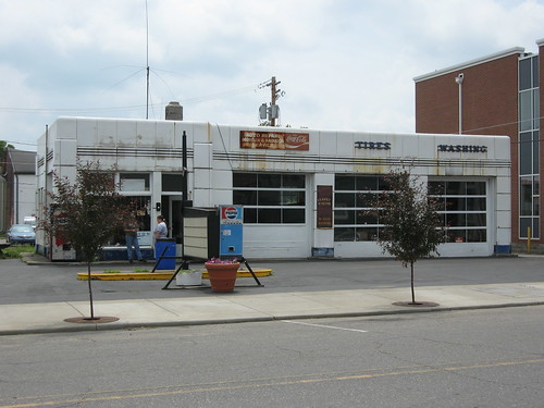
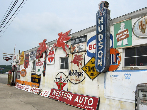
This was absolutely my day to see old gas stations. This was just the first of many.
1844 church. The old road turns right here, off Main and onto 4th St.

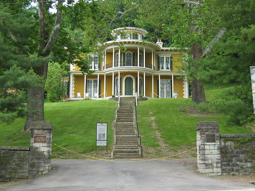
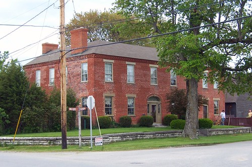
I saw this old house a block beyond the right turn and was drawn to it. The street has stone gutters here.
This Aurora resident came out to meet me. Introvert or not, I didn't mind his greetings one bit.

My 1916 ABB sends the driver down 4th all the way to the next town. A few blocks away from the church, there's a fork; 4th is on the right and Conwell is on the left. 4th looked barely passable -- an alley at best. So I took Conwell, which itself was closed for some sort of roadwork, and so I had to get on modern 50. The US 50 bypass of Aurora cuts this old route in two, but here's a photo from current 50 of old 50 (Conwell).
The old road picks up later on the other side of 50 and then trails off in the woods. I didn't explore it -- something about the area screamed "unfriendly to people not from here."
-
There are some excellent online ways to self-publish today. Here's a Cnet article with some helpful info.
http://reviews.cnet.com/self-publishing/
I'd be willing to contribute some stories.
-
Dave, this is awesome! It sounds like you're just planning to take a survey of the route -- 200 miles a day is pretty speedy and does preclude detailed study. How much of the original route do you estimate still exists? jim
-
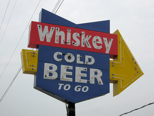
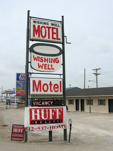
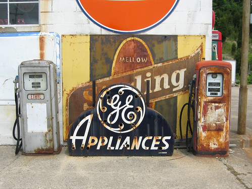
Some excellent signage along 50 between the state line and Aurora:
-
Yes, I stared Ohio down yesterday morning as I crossed in on I-74. But I wasn't there long!
I didn't see any cellars in Aurora! I did, however, see the stone gutters along some of the streets.
-
I got an e-mail the other day from a woman who said that she owned a house in Napoleon, Indiana, on the Michigan Road, that I photographed and place on my Michigan Road site.
She said that the house was built in 1822 by a fellow named Elias Conwell. I looked up Conwell and it turns out he was a wealthy businessman who moved to Indiana from Delaware, originally settling in Aurora on the Ohio River. They even named a street after him in Aurora. Further research suggested that Conwell St. in Aurora was the original alignment of US 50 through that town.
US 50. You know, a road on my short list for the summer. That's all I needed to make my decision. I toured US 50 today from the Ohio line to just short of Seymour (at I-65).
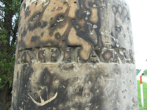
It took about an hour and 45 minutes to get to where US 50 enters Indiana from Ohio, and there I came across this 1838 state boundary marker.
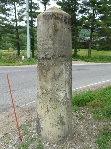
The text reads: "State Line as resurveyed under a joint resolution passed by Indiana on the 27th January and by Ohio on the 10th March 1837."
On the other side it reads "Erected Nov. 27th, 1838." On the Ohio side it reads OHIO, and on the Indiana side it reads INDIANA, to wit:
jim
-
Roadmaven, I'm thinking the Buffalo Trace definitely needs more research before I make a trip. But it's definitely on my list.
brownwho, I've traveled a bit of Indiana's US 6 here and there. It has some old alignmenty goodness along the way. I have family in South Bend just a bit to the north where 6 meets 31, so northern Indiana is not that big of a deal.
-
Thanks guys, I knew I'd get some good support here!
The Putnam County trip is tempting because it's so close, and my favorite road-trip buddy grew up there and she might know some history.
Emotionally, I'm still jonesing for more National Road, but yes, Denny, complicated is right out this season. I'm thinking maybe next Memorial Day -- I'll have three days to myself. And between now and then I can investigate dog-friendly motels on the route. That is, unless my old girl doesn't make it that far.
After doing more research on the Buffalo Trace, the thick plottens, as they say. Sources disagree on its route.
Some say US 150, others say that it's actually local roads in that general corridor. Hmm.....
If I break up US 50 into 3 or 4 parts, it would work just fine.
Anyway, I'm probably just going to have to pick a road and go! If the weather holds, I'll go Saturday.
-
It feels weird that I haven't made my first road trip of this season yet. But I've been quite busy with work and some long-overdue projects at home -- projects I put off in 2008 and 2009 in favor of the road. I absolutely need to not neglect my home another year, so I may not make as many road trips as I would normally. But I kind of have analysis paralysis over where to go this year, and now that's got me kind of stuck. Here's what I've been thinking about:
US 50 in Indiana - This road is cram jam packed full of old-alignmenty goodness, including some long ones. And you know how I loooooove the old alignments. It also promises to have some twisty parts, and I love twisty parts almost as much as I love old alignments.
The Buffalo Trace in Indiana - This road is about as old as it gets in Indiana. US 150 more or less follows its route today.
The Bridges of Putnam County, Indiana - My US 36 and US 40 trips across western Indiana both passed through Putnam County, where I've found some great bridges. This is largely a rural county, and (strangely for Indiana) its roads aren't a neat grid. I'm a fan and contributor over at bridgehunter.com, a catalog of US historic bridges, and it shows several through and pony truss bridges still in use on its country roads, and I'm thinking spending a day finding them all would be just wonderful.
The National Road in Ohio - You know I wanna. Of course, this would involve some overnight stays, and I'd have to bring the dog, so that makes it complicated.
I also continue to think about the Lincoln Highway and the Yellowstone Trail (what's left of it) across Indiana. And my last trip down the Michigan Road in southern Indiana showed me that a couple places I photographed in 2008 aren't there anymore, and so I'm feeling the need to do a recon mission.
So what do you all think? What should be my first road trip of the year? If the weather holds, I hope to make it this coming Saturday!
jim
-
This totally rocks! Thanks for sharing it.
-
I need all the help I can get!!!
-
As much as I enjoy AMCs, none of them hold a candle to this Hudson. This is my favorite body style of Hudson of them all, just totally bada** looking. I would love to have one someday.
-
It just makes me want to do the road in Ohio this year all the more!!!
-
Now THAT, my friends, is a CAR.
-
My understanding is that the property is priced at a level consistent with its value for investment (given that it's on two major arteries) and not consistent with reopening it as a diner. :-(
-
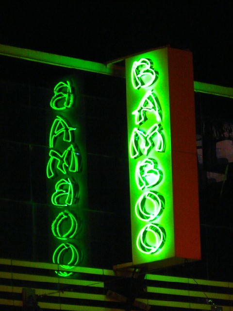
The Bamboo building looks like it's clad in Vitrolite to me, but I'm no expert.
Here's a photo of the sign, lit, reflecting in the panels, whatever they're made of.
-
-
It's too bad that the Florida bridge is closed. It's interesting that the barricade goes only halfway across -- it's baiting you to drive it anyway.
My other favorite road-related site, bridgehunter.com, doesn't appear to have a photo of the Hillman bridge in its database. (bridgehunter.com is a database of photos and data about historic bridges.) Consider this a plug for that great site!
-
Dave, these are great deja views. It is exciting to see this block still essentially intact. Is that Vitrolite on the second building from the right? jim
-
Sweet. The area around Elliott's Cabins -- wow, the old road was rerouted here bigtime.
I stopped last spring at that very Park 'n Dine for lunch.
jim
-
More popular than 66?!!? I can think of a whole bunch of small Indiana and Illinois towns that would benefit from that...
I recently "upgraded" to a Canon PowerShot S80 digicam with a 28mm lens -- and let me tell you, wide angle is the way to go for road photography. My previous camera, a Kodak EasyShare Z730, had a 33mm lens, which was on the wide side, but those extra 5 mm on the S80 really help.
-
Unbelievable that this has been going on for 60+ years! Do you know how this got started? jim
Us 50 In Indiana
in Lincoln Highway / U.S. 30 / U.S. 50
Posted · Edited by mobilene
I've been approached as I've been photographing small towns by people hoping I was a real estate developer come to revitalize their dying little burgs. They've been universally disappointed when I say I'm documenting the road!
I have had two people tell me some things about the road, both on the NR in Illinois. Here's one story: http://jimgrey.wordpress.com/2008/02/08/bursting-the-nostalgia-bubble/ . The other is at this page: http://jimgrey.net/Roads/NationalRoadIllinois/01_State_Line.htm -- scroll down to the photo of my former little red car about 1/3 of the way down, and read the two following paragraphs.
I occasionally explore the old roads with a companion. One is a woman, the other is a man. I'm much more likely to go into unfriendly-looking areas when I'm with the fellow. Matter of fact, he and I explored a considerable portion of the brick Illinois NR together, some of which was hidden from the modern highway and in areas that I would have been nervous exploring alone.
This page tells the story of the greatest abandoned road alignment I've ever found: http://jimgrey.net/Roads/SR37IndyBloomington/04_Johnson_County_700N.htm . It's Indiana State Road 37, the road between Indianapolis and Bloomington. It will become I-69 somewhere down the road. Anyway, I was kind of new to the whole roadsleuthing thing and hadn't developed my healthy respect for the hillbilly cannibals yet. At one end was that great abandoned alignment; at the other end was what I thought was an abandoned alignment but was really private property, and I got chased off by the police! You've got to see the photos, though -- they still astonish me.
jim