


mobilene
-
Posts
1,247 -
Joined
-
Last visited
-
Days Won
1
Content Type
Profiles
Forums
Gallery
Blogs
Calendar
Posts posted by mobilene
-
-
Denny, thanks for all the photos of the Plymouth. Some of the best I've seen. I also especially enjoyed the photos of the abandoned segments of old 66, but I can never get enough of that stuff! jim
-
Loved the pics of the old road stretching out. I think my favorite is the 2-lane ending for I-40 (was it?) and picking up on the other side. jim
-
Wow, I had no idea C. W. McCall had so many albums. I had the "Convoy" (b/w "Long Lonesome Road") single as a kid and about wore it out. jim
-
Consider it sucked up, sir!
-
Thanks for the link, man. Just what I need, another reason to kill a whole evening on the Internet! ;-)
-
My mom, bless her heart, cut out an article for me from IN Michiana Magazine about the Lincoln Highway in South Bend, where I was raised. The article itself is pretty lightweight but it does have two old photos from the road, one of a streetcar stopped along the road in town, probably from the 1930s, and another of the road being built, parts unknown. The photos were supplied by the South Bend Mayor's Office, which seems like an unlikely place.
The magazine is available in its entirety as a PDF file online. Go here:
http://www.southbendtribune.com/apps/pbcs....GORY=inmichiana
Until the July, 2007, issue comes out, click the "current issue (PDF)" link to read it. Otherwise, click the "past issues" link, and click "June, 2007" on the page that appears. Then scroll down to page 40.
My main memories of Lincolnway through S.B. as a kid were of when I had to go to the doctor -- his office was on Lincolnway West. So I didn't much care much to be on Lincolnway when I was little!
jim
-
Thanks for posting it! I glanced through it and like what I see. I'll set aside more time to look through it tonight. jim
-
It's been a long time since I read the article. If I recall correctly there was mixed success, with some bikes being stolen. I tried to search for info about it on the Net, but a couple minutes of searching didn't turn up anything. Wish I remembered more. jim
-
Didn't they try something similar, but with bicycles, in Seattle a few years ago? Bikes were left around the downtown area, and if you saw one you could ride it to your destination and leave it for the next person who needed it. jim
-
Let me make clear that Bainbridge is not the kind of small town you describe. It is too small! There's nothing really there -- no hospital, that's for sure, and probably no school. Main Street is decaying storefronts, not viable businesses vital to the town. Well, except for the bars. You know what I mean.
jim
-
When I was probably a teenager -- this was the early 1980s, maybe -- I saw an issue of Hot Rod with a story of somebody driving old 66. It was a mindbender to see the photos of the old segments.
I never forgot that. It was the first Major Event in my addiction.
The next was last summer when I made my first official road trip and found a short abandoned segment of US 40 west of Indianapolis. I was a goner!
jim
-
Bainbridge is still pretty out there. The worst of the suburbanization ends west of Danville. By the time you hit the county line, you see nothing but fields until you come upon Bainbridge. The town looks pretty depressed, economically. Things look a little rough all over. jim
-
I liked the little town shot. I couldn't quite make out what the flag sign said.
I can't make it out, either, not even when I look at it at full resolution. It looks like the flag was painted over the "Hanks Bros" sign, and covered up most of the text.
jim
-
I created my first area in the Gallery today and posted some photos of old alignments from my recent US 36 trip. Included is one with a covered bridge, one that goes into a lake on one side and comes out the other, and one that's unpaved (i.e., dirt) and one lane wide.
jim
-
Now that's a great list. I have seen some of this stuff in little towns I've driven through. I'm reminded of tiny Marshall, Indiana, with its two columns with a shallow arch going over the road saying welcome to the town. Now, that's on a state highway (SR 236) and it's actually in the middle of town, so maybe it's not the same thing as you describe.
But I hadn't considered looking for these artifacts to appear off the road as a sign of where a road used to go.
Is it basically true that banks, hotels, train depots, and schoolhouses tended all to be on what was (at least at one time) the main road through town? For example, US 36 curves north to bypass downtown Bainbridge, IN (a tiny town), and then curves back again. It seems pretty obvious that the downtown route was old 36 based on how it was in perfect alignment with US 36 just before and just after town. The road wasn't signed Old US 36, which is typical for segments of former alignments out there -- it was signed 700N at each end, and Main St. going through. Main St. was another clue since towns tended to center around the highway in days gone by. But I guess there are two other clues I didn't consider. First, on a corner of that old main street was a building with the door cut at 45 degrees and the word BANK carved into the stone above it. And on the opposite corner there was a large building, more architecturally interesting than anything else, with painted ads on one side. Maybe that was the hotel.
Anyway, interesting stuff. Thanks!
jim
-
I've stopped for dinner in Bardstown and enjoyed my visit there. Another day I'll stop and see more.
Corydon is a nice little town with lots of history since it was the first Indiana capitol. The original statehouse and governor's residence are still there, as is an early school just for black children (that there was a school at all for them was a big deal at the time), and the stump of a great elm tree under which most of the Indiana Constitution was written. Just south of town on old State Road 135 is a park commemorating the site of Indiana's one and only Civil War battle, and one of two north of the Mason-Dixon line (the other being at Gettysburg, PA). Also in Corydon is what's supposed to be a very cool glassblowing company. I haven't been, but a friend of mine who has family there has been dozens of times and says it's well worth the visit.
I like Nashville a lot, but forget going there when the fall colors are at or near peak. It's wall to wall cars.
A couple places worth stopping if briefly along US 36 are Danville, IN, home of the Mayberry Cafe, which usually has a 1963 Ford sedan painted to look like a police cruiser out front; and Rockville, IN, which has a few antique stores and places to eat along its square, three sides of which are still in brick. In Rockville, if you head east out High St. and bear right at the first (I think) turn, that road winds all the way to the covered bridge at Bridgeton.
jim
-
Roadside artifacts as I call them, or roadside architecture as it is often called is fun to discover and identify.
Wow! What a great list. I never knew about the roadside fountains before. Thinking back, I now recognize some garages and at least one old gas station (that looked kind of like a house in 3/4 scale) that I saw east of Terre Haute.
jim
-
Here are some things I've learned.
First of all, I research every road trip beforehand by going to one of the satellite map sites. I use Windows Live Local right now. I scroll the map along the entire route I want to take and I look for segments of old alignments. They're not hard to spot. Frequently, the road will even be labeled as "Old Route xx" or by the road's pre-1926 name (National Rd., Dixieway South, etc.).
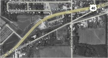
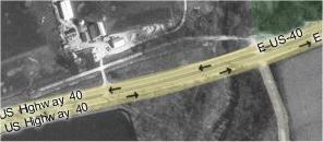
One thing to look for is where the road curves, and then curves back. Frequently, the road was moved from an original straight alignment. Here's an example from US 40 in Plainfield, IN. (All of my examples are from Indiana.)
NOTE: If the images aren't appearing for you, it could be because they're hosted at my personal site, and the host appears to be having issues.
Another thing to look for is a short segment of road that begins at the highway, curves away, curves back, and ends at the highway again. Frequently, the ends of the old alignment will be curved so they meet the highway at right angles; this is done because it's safer to turn left or right onto the highway.
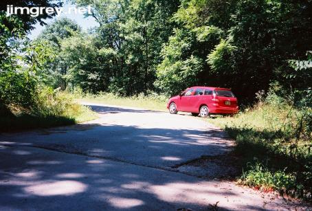
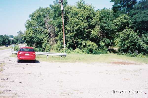
When you drive along these short segments, frequently the old road is of one pavement type, and the curved ends of another. This photo along US 40 shows how the pavement changes as the curve begins. The photo doesn't show it well, but a 2-lane cement segment becomes a narrow paved path here.
Look for where bridges might be. Bridges sometimes get replaced, especially if the old bridge's abutment was at an odd angle with the road because for some reason those don't last as long and are harder to maintain. Bridge replacement projects often orphan an old segment of road because if you build a new bridge a short distance away from the old one, you don't have to close the road during construction.
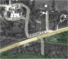
Here's a segment just east of Terre Haute on US 40, labeled as Kaperak Ln., that used to be US 40 before they replaced the bridge over the old Interurban tracks.
Satellite maps sometimes also show abandoned segments. Here's one on US 40 west of Plainfield:
It looks like a road is there from the air, but here's what it looks like at its eastern end:
Where's the road? The opening is along the photo's horizontal centerline. Scan about 2/3 of the way across the photo from the left and look for the hole in the brush. This segment was created by a bridge replacement. There was nothing on this segment of road, so it wasn't needed anymore and was abandoned.
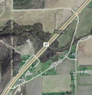
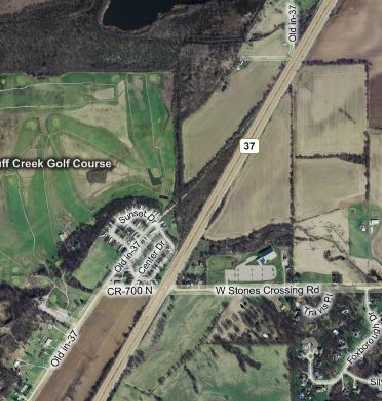
You can sometimes also find abandoned segments at either end of a curved old segment, beyond where the road was curved to meet the current highway at a right angle. Notice that north of 700N, there's a short segment of Old IN 37 and then this thin line or ridge vaguely in the same direction as the road. This is an abandoned segment. (This is State Road 37 in Johnson County, which is the county just south of Indianapolis).
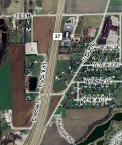
I've also had some success looking for roads that don't intersect with the highway, but go in the same direction as the highway at the point where they appear to branch off. Here, State Road 37 northbound curves to run more purely north. But look, Bluff Road picks up and runs in the same direction as SR 37 did before that northerly curve. Bluff Road is SR 37's original alignment.
This is as much of what I've learned as I can recall at the moment. And my experience is limited to Indiana, that's for sure.
Peace,
jim
-
I have thought from time to time that I would offer some “insights” about finding and following the old alignments and understanding what to look for in recognizing the old roads. <...> And other folks here who will photograph an old concrete highway gutter or follow the old road through the sagebrush may want to add their knowledge. Then you, as both knowledgeable in the subject and skilled in the communication arts, might pull it all together into an organized and lucid whole for all of us to enjoy.
I think you and I are of like mind. I have been thinking about writing a guide for my site, based on what I've learned, about finding and following old alignments. I also wanted to tell the clues I've learned about finding abandoned segments. (My favorite clue is to follow the utility poles; they frequently follow a road's former path.)
If we, as a group, can pool our collective knowledge, I'll put it on my (unfortunately fairly large) to-do list to write it up. We can, of course, keep it here, but I'd also like to put it on my site, with attributions as contributors desire.
Peace,
jim
-
Thanks, guys for the nice welcome! I'm glad you enjoy my site. I like putting it together almost as much as I like taking the road trips. I like to write -- I was a technology writer in a former life. And these trips are a chance to improve my photography skills.
I've just gotten into the maps aspect of this hobby, but mostly for practical reasons: I want to see where roads used to go, especially through cities. My 1957 and 1976 maps of Indianapolis cleared up a lot of mysteries for me, but paradoxically raised a few more questions, such as "just how many alignments through town did SR 37 have, anyway?" Speaking of maps, I found a nice little cache of Indiana road maps online, from j1917 to 1928. Here's the URL: http://www.libraries.iub.edu/index.php?pageId=2978. Indiana's highway system exploded during these years, going from five roads to pretty much the system we have today.
Oh, and believe me, I've been tempted to go swimming in Raccoon Lake to see if I can see road underwater. I work with a woman whose parents live more or less out that way, and they say that when the Army lowers the lake's level every winter you can see more of the road. And yes, I am inclined to think that "Crossroads" was about Terre Haute. The guy who wrote the song, Robert Johnson, was known to visit Terre Haute. And a line from the song, "Goin' down to Rosedale..." is a fit, because there's a Rosedale just north of Terre Haute, a few miles east of US 41.
Peace,
jim
-
Thanks for the welcome, guys! Nice to be here.
I grew up four blocks from one of the branches of the Dixie Highway, or Dixieway as we called it in South Bend. My favorite route between Indy and South Bend is, of course, the Dixie Highway route.
My hosting company fixed the domain registration problem; my site is back among the living. To see detailed writeups, with photos, of my road trips, go to www.jimgrey.net and click the "Roads This Exit" graphic.
I'm eager to write up my US 36 trip from last week. I still can't believe that a dirt/gravel road is signed as "Old 36 Rd" out in Parke County.
Peace,
jim
-
I've only recently started buying old maps. I buy them on eBay and so far haven't had any problems. I'm not buying them for collector value, but to see where roads used to go. So they don't have to be crisp and pristine, although so far most of the ones I've bought have been like new.
So far I've bought 1937, 1956, and 1970 Standard Oil maps of Indiana, plus a 1957 Shell map of Indianapolis.
jim
-
Hello everybody! I'm Jim, a lifelong Hoosier currently holed up in Indianapolis. From my Northwestside home, I can hear the cars running at the Speedway, but I'm happily just north of all the race-day traffic.
I'm not sure how I came to love the road. My parents were no help -- Dad hated to drive, so we seldom went anywhere. My first job after I got my driver's license was driving for a courier service, shuttling papers small items all over northern Indiana and southern Michigan. To the extent it didn't make me late, I experimented with the two-lane roads that wound around the area. And when I went to college, I would do anything to get off the mind-numbing US 31-to-I-465-to-I-70 route from my hometown of South Bend to engineering school in Terre Haute. I found that the two-lane roads that cut through the countryside didn't take very much longer and could be a lot more enjoyable. And then I began to notice the signs on some highways that said, "Old Route xx." I tried following some of those and found greater peace, quiet, and beauty along the way. I became hooked.
I got serious last year when I decided I wanted to start exploring Indiana's highways. My first serious road trip was along US 40 from Downtown Indianapolis to the Illinois border. I plotted out all the old alignments I could find and, last July, a friend and I drove every segment. The most exciting part of the trip came just west of Plainfield when we found a short, non-driveable abandoned segment that the earth was trying to reclaim.
Since then I've been driving around Indiana whenever I can get away and the weather is favorable. My favorite trip was last Labor Day weekend when I toured some of the twisties between Brown County and the Ohio River. A few weeks ago I drove State Road 37's original alignment to Bloomington, which included a long abandoned segment and a really pretty winding segment the last 15 miles before Bloomington. And just this past Memorial Day, I drove US 36 from its original terminus at old US 40 in Indianaopolis all the way to Rockville. I found several segments of the road's original alignment, including two with covered bridges, one that was dirt/gravel, and one that is interrupted by a lake the Army Corps of Engineers built 60 years ago -- the road goes in one side and comes out the other.
I write about my road adventures on my Web site. Unfortunately, because of a snafu with my hosting company, it is down at the moment. I expect they'll realize that I did, indeed, pay to re-register the domain and will put it back up this week. When they do, I'll pass the URL along. But meanwhile, I have a few pictures of my State Road 37 trip on my blog: http://jimgrey.wordpress.com/2007/05/15/th...to-bloomington/.
Glad to be here!
Peace,
jim
Yellowstone Trail Time Travel
in Yellowstone Trail / National Parks Highway
Posted
I'm amazed by the quality of the light in your photos. You must have built some skills to have captured the dusk and morning light so well, and to have the neon and incandescent light pop!
jim