


Keep the Show on the Road!
-
Posts
2,829 -
Joined
-
Last visited
-
Days Won
26
Content Type
Profiles
Forums
Gallery
Blogs
Calendar
Posts posted by Keep the Show on the Road!
-
-
First let me thank you both for the wealth of information that you are passing along. This is great stuff, keep it coming.
My objective for this trip is to, just as you said, "immerse yourself in what travel was like 90 to 150 years ago in this country." I have no desire for a Disneyland type of experience. I plan on taking 5 or 6 days for the entire trip with most of it being spent between Carson City and Salt Lake City. As far as dusty and unpaved roads go - I look forward to it, that's why I went for the 4 wheel drive option when I bought my truck.
I plan on making the trip in the July-August timeframe. I know that is not the best as far as temperature is concerned but it is the only time I have available. I like to start planning a trip like this well in advance so that I can start making notes on my map about places to stop. I hate finding out after I get home about someplace that I should have stopped and didn't because I didn't know about it. So, thank you very much for the references, I have my homework to do.
Lastly, Dave, your stream of consciousness posting captured my sentiments exactly.
Rick
Rick,
Great!! You are doing it right! You have enough time for the trip, enough time to get informed in advance, and not a bad time of the year to go. With all that going for you, you are certain to see through your eyes, and in your mind, what the old west was really like.
Our “price” for the advice will be that you share your experiences with us. You are going to get to visit some places I’ve missed, because I didn’t have the knowledge I do now. I would really enjoy hearing about your trip, as will lots of others.
I want to give you a few initial suggestions because they have added immeasurably to my enjoyment of the Lincoln in the area. I already told you about the University of Michigan site which you must visit, You will enjoy it more and more as you begin to link modern sites with the old photos. I downloaded and printed some, and even ended up providing some for the museum at Eureka, NV when I stopped there. I put them in a binder so I could compare the then and now as I traveled.
Second, because it is a rare first hand view of the area you will be traveling, see if you can get a copy of Sir Richard Burton’s book. The copy I have is titled “The Look of the West 1860, Across the Plains to California.” He was traveling the route right after the Piute uprising and the destruction of several stations and the death of several station keepers. It is a great read throughout, and an outstanding and often cited original source. It will “background” you so you will start to build the mental map which makes traveling the Lincoln such a great experience.
If you jump to ABE.Com today you can pick up a used reprint for under 10 bucks. But I also note some of the dealers want over $100 for a reprint, so maybe you should buy it soon.
Third, I would also start to review the Pony Express. The old Lincoln and the Pony Express are interwoven and a trip on the Lincoln is also a visit to the overland stage and Pony Express routes. Again you can start with a web site. There are several good ones. What I would look for are accurate descriptions of the stations, their history, and locations. Franzwa does a good job, but he isn’t writing about the Pony Express, so he doesn’t attempt comprehensive coverage.
I don’t know how you and computers get along. You referenced Delorme. That shows you know your stuff! If you have a laptop, and you don’t own their Topo USA disk set with the GPS unit, spend the money now to get the combination. You will be happy you did, not just because you can plan the trip with great tools, but because it is possible to make a wrong turn in the desert and the GPS display on the map as you drive can prevent that problem. Plus its fun to know where you are in real time!
A bit on the esoteric side, but you might enjoy reading contemporary (1911-1920) news accounts of the route from Utah newspapers. I recall a story where the sheriff went out to learn why ranchers were turning their irrigation water across the road out on the stretch you will be traveling. When you add it up, the circumstantial evidence was that they were adding to their income pulling stuck autos out of the mud with their teams.
There is a notice in one of my Blue Books or Lincoln Highway Guides that you should build a fire using the sagebrush if you get stuck, and Mr. Thomas(or Jones) will come out with his team to rescue you. My guess is that Thomas was digging ditches by day, and renting his team at night! Just speculation, of course! The Sheriff came back empty handed.
Utah has lots of old newspapers on line, and a search on the Lincoln Highway turns up lots of gems. Search first for Utah digital newspapers, then read about how the Lincoln was viewed by the people of the time.
Those leads should get you started!
BTY, you mention “strip maps” in your first post. If you have original 1917 or 1920 era ACSC or CSAA Nevada or Utah strip maps of the Lincoln, stop using them immediately, protect them in plastic sheets, scan them, and use the copies. You might be holding the Holy Grail for old map collectors like me! I sold three Lincoln Highway Strip maps for $160 not too long ago, and they were in California. A set for Nevada would bring at least twice that on Ebay. I paid over $300 for just the 1912 road description a few weeks ago, and now I’m broke.
I have Automobile Blue Books and both original and reprinted Lincoln Highway Guides in my collection, as well as old Topos and copies of old maps. I can make selected copies for your review on the Forum.
Well, that’s another drink from a fire hose.!
Thanks for helping Keep the Show on the Road!!
Dave
-
I have a question that I hope somebody on this board can help me with.
I am planning a road trip following the Lincoln Highway from the San Francisco Bay Area to Salt Lake City. I am using a strip map (year unknown) as reference and trying to re-concile it with the Delorme Gazateer for Northern California, Nevada, and Utah. Finding the general route is not a problem until I get to Ely, Nevada. From their the strip map that I have shows the Lincoln Highway going north out out of Ely, then east through the Shell Creek Range and Antelope Range to Ibapah & Gold Hill, Ut. After Gold Hill the road heads south and then east across the Great Salt Lake Desert.
My questions are these:
Is the part of the Lincoln Highway that passes through the Great Salt Lake Desert still accessible or does it lie within the Dugway Proving Grounds? There is a road shown on the Delorme map that goes south of the Dugway Proving Grounds labeled as the Pony Express Trail but I do not believe that this road is the Lincoln Highway.
Also, has anybody driven this part of the Lincoln Highway and can you offer any advice? (other than gas up and carry plenty of water?)
Cheers,
Rick
Why would I drive the old Lincoln between Ely and Salt Lake? Because no where else in America can you truly immerse yourself in what travel was like 90 to 150 years ago in this country. Now that is a pretty bold statement, and if some of my forum friends want to dispute that opinion, let the fun begin!
As you well know, the two lane roads of America provide wonderful windows into the past, and a palette for the senses that is almost never offered on the interstates. It is hard to find an old two lane road not worth traveling. And I love them all. Each has its special character. You truly can get your kicks on old Route 66, and as far as I’m concerned every American should. And a drive along the Oregon Coast on old 101 will make you forever hunger for salt water taffy and the crash of Pacific breakers on a rocky shore.
But the Lincoln in Nevada and Utah will make you marvel at what early auto travelers routinely experienced, and even what stagecoach travel was like in 1861. It is truly possible to hear and see in your mind’s eye a Pony Express rider approaching in a cloud of dust, or envision the 1915 auto traveler who perhaps stayed in the bunkhouse at Eastgate, carving his name and initials into the sandstone wall before he left. And who can pass a deserted brothel in the middle of the desert without at least a little reflection?!
I recognize that folks differ in their preferences, so I need to be clear about what the Lincoln in this area is and isn’t. It definitely is not anything like Las Vegas or Disneyland! And what is there has not been “restored.” You won’t see a Living Museum of Pony Express History, complete with shootout and Indian attack.
What you will see is westerners still living a small town or genuine ranch life. And if you know where to look you will find the past quietly laid out before you in so many ways you will leave with a lifetime of memories. And perhaps best of all, it will be yours to enjoy without crowds, waiting lines, or for the most part, other tourists. In fact, it is likely to be at times a lonely experience on the Loneliest Road in America. If you don’t enjoy the shadows and roadways of your mind, you may not like the Lincoln as much as I do.
It won’t always be that way because, as you well know as a pro yourself, old road travel is growing by leaps and bounds. If you are a young man, do it before it is overrun with folks looking for souvenirs to carry home, and if you are an old codger like me, do it before you are confined to your easy chair!
You could make the whole trip without rolling a tire on an inch of dirt road. Or you could go for the full Monte and travel about 150 miles of dust and dirt, past ranches, express stations, and desert watering holes, like it was in 1913 or 1919. Or you could do about 90 miles of smooth dirt, and enjoy a really good sample of the old Lincoln, without a compass! If you don’t do at least the 90 mile sampler, you will kick yourself forever.
Before I close this little stream of consciousness, I want to add a unique resource to your list. It is easy get, free, and an unbelievably rich treasure trove of old Lincoln Highway photos. Go the University of Michigan website and look at the photos taken in the teens along the Lincoln in Utah and Nevada (and California for that matter). The UofM has the Lincoln Highway archives on line, and it is unbelievably rich. (I’d do a Google search on “University of Michigan” “Lincoln Highway”)
Many of the sites you will view in the photos are there today. One of my favorites is the one of Tippets (or Tippetts, or Tippet, depending on who spells it) Ranch about 70 miles northeast of Ely. You can stand today where that picture was taken and nothing but the roadside sign has changed. Even the huge wooden hay lift is still there, as are the buildings.
More later, as my objective is to Keep the Show on the (American) Road!
Dave
PS. Denny's the man! He is so well connected and informed he practically glows. I do have the advantage of having driven a good deal of the route between Ely and Salt Lake City, but not all. I'll post some pictures and maps. When do you plan to leave?
-
Thanks for the info Denny. I will definitely have to pick up a copy of that book and read it before I hit the road. I've looked at the area on google earth, looked at the topo maps, but none of that can really give you a true picture of what the traveling would be like. To bad that section is sealed off within a military base and the bypass around it doesn't sound like to much fun.
Cheers,
Rick
Here’s a case where being right may provide the wrong advice! DennyG is one of our most knowledgeable members and he is correct, you can’t stay on the Lincoln all the way between Ely and Salt Lake City. You will have to detour around Dugway along the Pony Express Trail for about 40 miles, but that isn’t exactly a bad experience! In fact I consider it a bonus.
When you are out buying books buy two of the Gregory M Franzwa series, The Lincoln Highway - Nevada and the Lincoln Highway - Utah. They are the definitive word on the Lincoln in those states. Franzwa is the founder of the modern Lincoln Highway Association and he not only provides detailed descriptions of the road and pictures, he provides hundreds of detailed maps showing the route.
I have traveled much of the Lincoln in both Nevada and Utah several times, and you will regret it if you miss the Ely to Salt Lake drive. It can be taken in a passenger car and I have done much of it in my sedan. The only real deterrent is weather as it is dirt and will become slippery mud in any serious rain storm.
I had planned some time ago a post and pictures of the road as far east as Ipabah, but hesitated because my last trip was a year and a half old, and therefore a little stale. I think now I may finish it and post it.
I am a long time Lincoln Highway fan and I promise you are in for some sweet road tripping on the old Lincoln in Nevada and Utah. There are fascinating sites all along the way, and because much of the road follows the Pony Express and Overland Stage routes of the 1860’s you get a double treat. The towns, old Hotels, deserted ranches, and abandoned Pony Express Stations along the way will take you back to the old west like no where else, and I know!
For example Sir Richard Burton made a stage coach trip along the route in 1861. At the Sand Springs Pony Express station he describes a man dying in the corner of the room. In the 1970’s the station was rediscovered buried under the sand and preserved for those who will walk a few hundred yards. You can stand in the old rock station, beside the fireplace where the man lay dying, and unless it’s the 4th of July, you are likely to be completely alone with only the sound of the wind blowing, as it did then.
Or stop at the International Hotel in Austin and have one of the best burgers you ever ate. The old International has been serving Lincoln Highway travelers since the beginning, and looks like it did back then. Or stop at the bunkhouse at Eastgate and look at the names and dates carved for the last 90 years by travelers along the Lincoln.
Spend awhile at Stone House where a Pony Express Rider took an arrow to the skull, and Lincoln Highway travelers stopped for water and perhaps a meal. You will have the place to yourself, without the fear of arrows.
Stop at the deserted Tippetts Ranch where a young Dwight Eisenhower and his army convoy stopped and camped in the teens, and where early travelers wet their whistle at the bar and got suppilies and gas at the store.
The goodies go on and on.
When do you plan to make the trip. If you want suggestions, all of us can help.
Oh, and I have old maps of the Lincoln from 1913 on, and turn by turn directions from 1920 and before in my collection. Happy to share in any way.
(And BTY I am writing this from memory so I will correct any mistakes in dates, etc )tomorrow
We have to Keep the Show on the Road
Dave
-
I made it home last night about 9:00 after a pass through Indiana to make this a true Okyana outing. Bob & Susan were planning on further exploring the Phantom Highway then returning to the Wigwams for one more night. They were gone before I came out of my own tepee. So were Kent & Mary Sue and the Bremers Corvair was soon gone, too. When I left, RoadDog was contemplating a stop by Dinosaur World followed by further meandering. The report of my third and final day out has been added to http://www.dennygibson.com/wigwam042007/index.htm
I'm ready to go again. Curse this paycheck addiction.
The Dixie Highway event inspired me to plan an inspection spin along the Yellowstone in eastern Washington. I thought I might do it this week but we are “enjoying” a forecast of clouds and sprinkles, so I’ll wait for at some promised sun breaks.

No problem, I can go any time because I don’t suffer DennyG’s paycheck addiction any longer. I tried it for 35 years and didn’t like it! Actually, I had a wonderful career, but retirement is even better.

I know the Yellowstone fairly well from both reading and traveling, but there are always new “discoveries.” For example, the last time I was in the village of Rosalia, south of Spokane on the older southern loop, I “discovered” a beautiful restoration of an old Texaco station. And I may have spotted an original painted YT arrow (I would attach photos but apparently I’ve exceeded my 500K allocation of “global” attachment space. Either that or I’ve been banned without knowing it!
 The moderators are looking into it.).
I am pondering the possibility of suggesting a group trip on the Yellowstone in Eastern Washington like the one you folks did on the Dixie. Do you have any helpful hints? What works, what doesn’t? I would probably shoot for a long weekend in late September or early October.
I have some ideas in mind, but I don’t want to get too far ahead of myself until I check out some places.
Anyway, would anyone on the Dixie trip (or similar) like to offer some advice? I’ll also start putting out some feelers on the Yellowstone Trail section. Maybe John or Alice will have some ideas.
I want to Keep the Show on the Road!
Dave
-
I think I may take a few days next week and savor a bit of the Yellowstone Trail in eastern Washington. Sheila, Rose of the Road will be baby sitting at the grandkids, so it would just be me and Bo, the Malamute Wonder Dog.
If anyone has advice as to places to stay, eat, or visit, let me know. I’ll take the laptop and try to stay where I can get wifi so I can keep a running post of the trip in the Yellowstone Trail section of the Forum.
I think I will look first at the post 1925 route via Cle Elum, Blewett Pass, and Waterville. The Waterville Hotel, built in 1903, was host to many a YT traveler. It is nicely restored with original period furnishings.
I may also swing down from Spokane along the earlier southern loop of the Yellowstone and check out the wonderful small towns between Spokane and Walla Walla along the old road.
And I plan to take a look around Ellensburg. The original pre 1925 dirt road from Ellensburg toward Yakima is an interesting ride, and other than being better graded and maintained now, it is largely unchanged.
Let me know any ideas for eats, photos, lodging, etc.
Trying to Keep the Show on the Road!!
-
I surprised myself by getting Saturday's journal up before heading out. I guess I'll also surprise myself by wherever I go today because I've yet to pick a path home.
Anyway, the weather turned out great yesterday and there's no doubt everyone enjoyed themselves. Check the link in the previous post for the journal.
I must be off.
I understand…fun comes before reporting. And I had already enjoyed your earlier journal entry, thanks.
I don’t know if it’s a case of the grass is always greener on the other side of the fence, but your itinerary sounded really interesting. It prompted me to pull out some early descriptions of the area, when the road was “gravel or rough and stony” on the Dixie along your route.
The image of the blue grass of Kentucky and the sipping of a fine bourbon by the wigwam has an appeal for an old westerner who used to fortify himself against rattlesnake bites with a little Jim Beam! When you do report again, maybe include a bit of a description of the country side. In 1920 it was sparsely settled hilly farm country, according to the 1920 Auto Blue Book.
I’ll look forward to the rest of the story!.
Gotta Keep the Show on the Road
-
Neither rain, nor sleet, nor... Sleet? Well, sleet maybe. That might stop us. Maybe. But definitely not this wimpy rain. We're here (8 roadies, 5 states) and we're ready for the 31W-62-31E triangle. Not much happened on the road yesterday and the developing lab ate my carefully posed group shot but there is a bit of a start at Wigwams 2007 and more will follow.
OK, the dog ate your homework, huh? We are sitting at the edge of our easy chairs looking for the next report.
Let’s Keep the Show on the Road!
-


The Pacific Highway, later US 99, follows the Cowlitz Trail northward between the Columbia River and Olympia, Washington. This is the northern branch of the Oregon Trail, which carried the first white settlers from the United States into the Puget Sound.
The site of that first settlement at Tumwater Falls on the Deschutes River is within a few hundred yards of the now closed Olympia Brewery with its familiar slogan “It’s the Water.”
The old Brewery offered tours and was a familiar stop on old 99. Anyone who took the tour will remember the great copper kettles, filled with a swirling mixture of hops and yeast, and of course the water from artesian wells. And if you were old enough, you got to sample the brew.
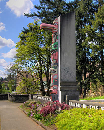
In 1936-37 the Pacific Highway was rerouted a bit so that it was carried across the Deschutes on a new art deco bridge that featured a pair of totem poles at each end. It provided a fine view of the brewery. The bridge was built as a depression era public works project.
The bridge, totem poles, and art deco lamp posts are still standing and in excellent condition. The bridge carries traffic on Capitol Way. The totem poles are a familiar reflection of the region’s Native American heritage, but with a modern (1937) art deco influence.
Headed north you can turn left (west) just across the bridge, go about 200 yards and turn left again down the hill beside the brewery. This is the pre 1937 route of the Pacific Highway. It crosses the Deschutes River on a recently renovated bridge. At the west end is a small monument placed by the DAR in 1916 to commemorate the northern end of the Oregon Trail. Looking straight ahead (west) on the new bridge you see a lovely 30 foot retaining wall and savor the sounds of the I-5 freeway. Before the freeway paved over old Tumwater, you would have been looking at the Tumwater Drug Store and the north end of downtown Tumwater.
A turn to the right will take you to the Tumwater Historical Park (watch for the sign on your right) and a view of the original Brewery which was at water level at the very end of Puget Sound. As you drive out of the park, you may enjoy visiting the home of Bing Crosby’s grandfather, Nathaniel Crosby III and the Tumwater Historical Society across the road..
You can backtrack to the intersection at the north end of the totem pole bridge (officially the Capitol Boulevard Crossing Bridge) and turn left (north) to follow old 99 into Olympia.
Does anyone have a recollection of old Tumwater, the bridge, US 99 in the area, or the brewery to share?
Just trying to Keep the Show on the Road!
-
As was common in the 1940’s my father worked a 5 and a half day week, working until noon on Saturday. He came home and worked in the yard, then if we were lucky we headed off for Burbank (California) in our 1949 Chev torpedo back sedan to Bob’s Big Boy Drive In and later a movie at the San Val Drive In theater on San Fernando Blvd.
The restaurant, which I think still exists, was a combination drive in and sit down affair, but I don’t recall that we ever went inside. We pulled up to an empty stall and ordered our food from the carhop.
I may be wrong, but as I recall they wore a red (maybe brown) cowboy hat and neckerchief, and a white blouse. She delivered the food and attached the tray to the top edge of the window, in our case usually on the passenger’s side, as Mom doled out the food. The tray had rubber tipped legs that were adjusted against the outside of the window and secured with a large knob that tightened a slider.
Some may think the Big Mac was the first double deck hamburger but Bob's had the original double decker. It was delivered on your window tray in a little white wax paper sack with a Big Boy image on it. It had a French dressing type sauce I still recall and which probably contributed to my preference for French dressing on my salads today.
If you needed something, or when you were finished, you blinked your headlights to attract the carhop. It was considered impolite to honk your horn.
We raised our own rabbits and chickens and most home cooked meals featured one or the other. A Bob’s double decker cheese burger was the best thing I ever ate, until I was in my early twenties and had a filet mignon at the Domino Club in San Francisco.
Keep the Show on the Road!
-
A new report does not bode well for what is perhaps the oldest bridge on the Lincoln Highway, but you can email words of support.
The bridge over Poquessing Creek, at the border of Philadelphia and Bucks Counties, PA, was built in 1805 for the Byberry-Bensalem Turnpike, and improved in 1917 as Lincoln Highway traffic began to overwhelm it. Since busy Roosevelt Boulevard bypassed it in 1921, it has slipped into oblivion, leaving it a very rare remnant in a very urban environment (right behind a Lincoln Motel). The bridge leads into Benjamin Rush State Park but straddling the county line has led to unclear ownership and lack of upkeep.
The report cataloged and ranked 125 Philadelphia-area stone arch bridges, which is the problem - unlike some, the Poquessing Creek Bridge is not needed for traffic, and is not eligible for listing on the National Register because of scouring (the undermining and deterioration of the base due to water erosion), making it "not a strong candidate for preservation." It is ranked 62, but only about 40 bridges will receive any maintenance or preservation.
Former LHA state director John Harman, who talked with the consultant, reports, “The bridge is artificially ranked as high as it is (right in the middle of the 125 bridges) because of its historic value associated with the Lincoln Highway. Otherwise, it would be lower. The Pennsylvania Historical and Museum Commission has also recently advocated for the bridge's preservation and higher priority status.”
You can see the full Draft Management Plan at http://www.pastonearch.org/ with details on pages 126-127, aka B44-45, but the 28M file takes a while to download even on fast connections.
For a summary of this bridge, go to http://www.pastonearch.org/index1.php
In the Search line, choose the county Bucks, and a map will soon come up with a list of bridges. Click #24 PHILADELPHIA - BUCKS CO LINE
You will get a map of the bridge and an overview. Click on Report and you’ll get more info in a new window.
If you'd like to send comments, go back to the main page http://www.pastonearch.org/ and click "Your Comments/Contact Us."
Let officials know this is an extremely rare and prized resource of the Lincoln Highway, especially in the eastern half of the U.S. As interest in the route increases, it will draw visitors from around the world much as bridges do elsewhere on the Lincoln Highway and Route 66.
Also some photos and info here:
http://www.amusementparknostalgia.com/lincoln.html
http://www.friendsofpoquessing.org/pathfin...inderv13i1.html
Brian Butko
Thanks for the heads up!
I took a look using Google Earth at the site, and if I am correct it is the bridge at lat 40.1200, lon -74.9772. If it is that bridge, it is highly accessible, just a few hundred yards off US 1 via a signaled intersection off the main road, requires no lengthy walk, would readily be handicapped accessible, and even enjoys enough surrounding space for parking and a small interpretive site. To top it off there are existing tourist facilities immediately adjacent and a major hotel across the road..
It is the oldest arched bridge in the area , was once a link in the Kings highway, and is a fine example of the type. It also appears to offer access to a possible jogging or walking area along the old Lincoln Highway alignment and into the Park for hotel guests.
Do I have the wrong bridge? If not, it is certainly worth an effort to save it!
After all, we want to Keep the Show on the Road!
-
Quinn, Natalie and I recently made our Easter trek up to Northern Wisconsin...enroute we were able to take some of US 51, which is very well promoted these days in Wisconsin with the "Explore US 51" program...when we got to Portage, we stopped at an excellent little greasy spoon called the Levee Restaurant...it is an old truck stop from the 1940's, and the interior looks like it hasn't changed much from that time...the food (we had breakfast) was fantastic, and, from the pies sitting on the counter, it looks like they have some great pie! It is named for the Wisconsin River Levee which is right across US 51 from the place...It is a great place to stop taking your "highway 51" trip, and I recommend it (and taking US 51 from the IL border to Portage and points North...Tsingtao Kip
Thanks for the tip! But how does a guy pass up homemade pie? Must be it’s a lot easier to come by in Wisconsin than it is out west!
Never been into that area. I took a look via Google Earth. It looks like heavily farmed prairie country.
What are the highlights of a drive along US 51 in the area? Streets and Trips shows several small towns centered on the railroad that spill over to US 51 when it runs near the rail line. What are the small towns like?
Your post led me to visit the Wisconsin Department of Transportation site. Some states, such as mine (Washington) provide on line access to a photo data base of every foot of state roads, usually with the view ahead and to the right. I didn’t find that in Wisconsin, but I did discover an interesting program they call Rustic Roads.
They have identified over 100 rural roads with special character. I clicked on a few and they sound like terrific side trips on any two lane trip in Wisconsin. I looked for one along your route on US 51 and the route described below popped up as an example.
“Rich in heritage, Dyreson Road travels through fertile farmland and wooded areas. The road offers an excellent view of Lake Kegonsa as it crosses County B. Historic Dyreson Bridge over the Yahara River is the site of early Indian and pioneer crossings and is adjacent to ancient Indian effigy mound sites. Nearby wetlands provide glimpses of native waterfowl, fish and wildlife. Also located on the road is Dyreson House, an early Wisconsin homestead listed in the Wisconsin State Historical Society’s Inventory of Historic Places.”
(I have included the Ken Zingg photo of the Dyreson Bridge from the Wisconsin Department of Transportation Site)
That’s some 2.9 mile stretch of road! And many of the others are as interesting. Bravo to Wisconsin. A great idea!!
Thanks for the post and Keep the Show on the Road!
-
Fordtractor, with the photo of the abandoned mining shack:
Abandoned Mining Shack - fordtractor
Congratulations!! Becky Repp, AMERICAN ROAD'S Coordinating Editor & General Manager will get in touch with you regarding your prize! Be on the lookout for your photo on AMERICAN ROAD's home page as well!
Thanks to everyone who entered...your photos were all fantastic and stayed tuned for your chance to enter another photo contest VERY soon!!!
Congratulation to Fordtractor! A great shot of the old mining activity at Mosquito Pass! You caught the clear blue of the Colorado skies and the warm tones of the old wood building perfectly. Lots of impact.
It has been 40 or 45 years since I was there, and it’s great to see that it is just as photogenic as back then! Takes me right back! Did you do other photos of the buildings?
-
That picture of Meteor City in the April photo contest was strictly breathtaking. Everything worked. An artist could not have painted a better scene.
We purchased a picture of the Blue Swallow Motel sign with a drop-dead gorgeous sunset this past fall. The owners said they set up a camera and taken several hundred shots to get that special one of blues, oranges, and even a sliver of green. That sunset against the sign in the foreground, wow!!!
Thanks for the very kind words!
I wasn’t a Route 66 fan until my wife, our big Malamute, and I took a trip along it in the Southwest this winter. Thanks to the good folks at American Road Forum, we were steered in the right direction as we traveled.
I like the Meteor City shot myself because it seemed to shout out Route 66!
Frankly I was amazed at the photos opportunities. All my shots are spur of the moment, and there were lots of great moments on old 66.
I took my first trip along US 66 in 1951 or 52 as a kid in the days when we carried a water bag hanging from the front bumper. Of course this was before air conditioning.
The trip was made in July from LA to Grand Canyon and back. Dad had purchased a wind driven evaporative cooler that hung on the passenger’s window, sort of like a drive-in food tray. It looked like a small barrel on its side with a wind driven fan in the front that turned a cloth covered drum into a pool of water in the bottom of the barrel. It had a duct that was supposed to divert the “cooled” air into the car.
The primary virtue of the “cooler” was the fine mist it sprayed on back seat passengers as we drove through the desert!
Thanks again!!
Keep the Show on the Road!
Dave
-
Experian Automotive has prepared a list of vehicle statistics for the state of Illinois. Some of their findings of vehicle registrations were quite interesting. Here are some:
There are 9.6 million vehicles registered in Illinois (240 million in the US). Of them, 56% are cars.
Weird Wheels:
53 Yugos- STILL??? I thought they'd all broken down
156 Volkswagen "The Thing"- whatever that is
3 Renault Fuegos- Again-- ????
36 AMC Pacers- these and the AMC Gremlin get my vote for UGLY
47 Chevy Corvairs -Unsafe at you know what
141 DeLoreans
74 Merkur Scorpios- ?????
191 Ford Pintos- my first-ever new car purchase, $2200 in 1973. Just don't get hit in the rear!!!
Fast Wheels:
35,404 Chevy Corvettes
14,032 Porsches
934 Dodge Vipers
479 Ferraris
81 Lamborghinis
Keep on Down that Two Lane Highway. --RoadDog
Ah, come on…You know…THE THING …rectangular, Jeepish, often orange, convertible metal box with what looked like corrugated steel sides. They were selling in the US (1973-74) when you bought your new PINTO in 1973. Remember now? Bet you wish now you bought it rather than that Pinto. Right?
Thanks for the list!!
Keep the Show on the Road!
-

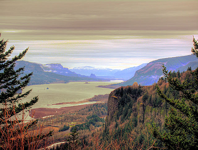
I note that the Columbia River Highway is among the vote leaders in the West in the voting for favorite drives. I agree! It is always a beautiful drive, any time of year. We have taken it many times, including two visits this winter (12/06-1/07).
If you are not familiar with the highway, it is the two lane road designed in 1916 by famed highway engineer Samuel Lancaster along the south side of the Columbia River. The history of the road is almost as fascinating as the road itself.
The road follows along the Oregon side of the River. It was an engineering marvel in its day, because the Columbia runs through a steep walled volcanic canyon carved out in part by the humungous Missoula Lake floods of the ice age, about 15,000 years ago. The Missoula Floods were so gigantic that they swept huge boulders the size of locomotives many hundreds of miles, and scoured the land in much of the eastern part of Washington, in the process forming gigantic water falls (e.g. Dry Falls) that dwarfed today’s Niagara.
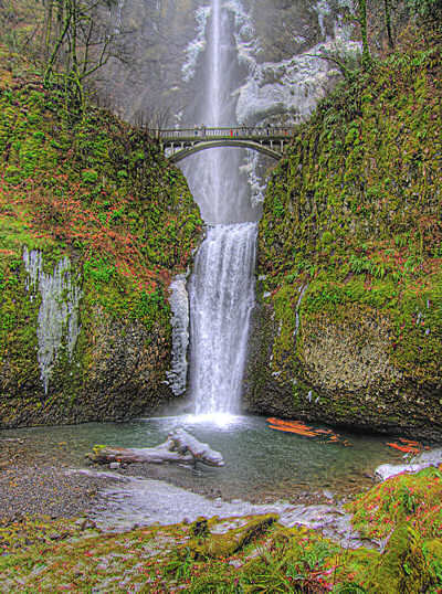
Creeks entering the Columbia were cut through by the 650 foot deep rushing water and now fall hundreds of feet into the canyon. Multnomah Falls (620 feet) in the photo is the best known.
The Columbia cuts through the Cascade range of Mountains on the route followed by Lewis and Clark. Many of the landmarks they note in their journals are landmarks along the Columbia River Highway today. For example, in the photograph of the river from historic Chanticleer Point (today called Women’s Forum Viewpoint), in the far distance on the left is a basalt plug called Beacon Rock by Lewis and Clark. This view is upriver, looking east.
The photograph of Multnomah Falls was taken when the temperature was low enough to freeze the mist onto the banks. For scale, the spots on the bridge are people viewing the falls. Lewis and Clark note the falls: “ ….streams fall from a much greater hight, and in their decent become a perfect mist which collecting on the rocks below again become visible and decend a second time in the same manner before they reach the base of the rocks.”
The old road can be entered at several places. Coming from the west, I find the best exit off the I84 freeway is Exit 22 to Corbett. This takes you up to Chanticleer Point, the site of the river photo. You can then stop at famed Crown Point (the building in the river photo) and take the serpentine road down to the river and Multnomah Falls. Westbound, take Exit 35. If you want to travel the old road, don’t assume you can take the Multnomah Falls exit off the freeway!! It does not connect with the old road and leads you to a large parking lot instead.
Finally, the Columbia River Highway is now officially the Historic Columbia River Highway. It was also a part of US30 and before that, the Old Oregon Trail auto road (for auto trail fans).
Keep the Show on the Road!
-
I certainly find what old maps I have very useful in trip planning but it's more of an accumulation than an organized collection. And the acquisition wasn't particularly organized either. While what I have lets me find general routing, I find I'm getting a little more concerned with details and often coming up short. Guess I should start keeping an eye on eBay again.
I know exactly what you mean! I have many of my maps and travel guides in drawers, which makes them virtually impossible to easily locate. I did find a fairly simple way to organize them, however. I bought 2.5 or 3 inch wide binders and those clear sheet protectors. I then put a map in each sheet protector, grouping them by state or type. Now they sit on a shelf nicely.
I imagine I have one of the most comprehensive road map and guide collection in the Northwest (I’m sure Ypsi Slim of this forum has much more, but he’s not in the Northwest!).
I enjoy following an old road in my easy chair, then trying it on the ground, so to speak. I use the Automobile Blue Books a lot because they give pretty detailed descriptions and you can run the road both directions. For many of the western routes I also have strip maps, which are pretty good. I combine that with Delorme’s Topo maps on CD, which most often show the old road, and if necessary an aerial image like Google earth.
When you can find them, the historic USGS topos are also great. Many were done in the teens or 20’s. If you are following an old road, they will nail it down to a nat’s eyebrow. There are websites with most of the Northeast available, and some universities have made their collections available on line (eg Chico State in California, Washington State in Washington, etc)
In the Northwest and Northern California, the Medsker County Maps of the late 1940’s and early1950’s (pre freeway) are very useful, and usually cheap. We didn’t destroy or abandon a lot of roads between 1920 and 1950. Mostly we upgraded. I don’t think it was until the advent of humongous road building equipment that we cut through mountains, filled valleys and bee-lined the system.
There is nothing like being there to identify the old routes, but on a cold Northwest evening I can enjoy a virtual trip via map. And if one of the forum members has 49 trips already documented, on his website I can “virtually” drive the road!
PS. Did you ever read my second post (after I got home) regarding the Old National Trails Route question you posed. The ABB description of the Gallup route was as negative as I have ever read. It sure explained why the Springerville route was preferred!
-
I like the sound of the old maps and guides. Unfortunately living in Liverpool, not alot of American guides get over although I have a great old postcard book of Venice and a old travel guide to Denmark complete with map. I even found an old camera with a half used roll of slide film still inside. Still haven't gotten it developed yet. I'm looking forward to my next trip to the states to hopefully dig out some old guides at the thrift stores and yard sales. I tried to stop at the yard sales when we over last year. We were on Rt 211 in Virginia but the backseat teenage drivers had no time or patience for such things that don't involve air conditioning and food.
It was great reading about your collections.
Kind Regards!
Living in England you don’t have to take a back seat on maps!! Nor absolutely amazing two lane roads, (some closer to one lane with hedgerows!)
When I was in Hay on Wye bookstores years ago I picked up as many old Great Britain maps as I could put my hands on. They are beautifully done, and some are works of art! Mine aren’t valuable, but they are treasured in my collection.
I’ll have to pull a few out and enjoy them again!
The British are master map makers, and guide makers to boot. I don’t think they get the kind of attention here they deserve! And of course your AA produces excellent modern maps and guides that are invaluable.
I used to own a 1958 MGA, jet black with red interior, with spoke wheels, so I can claim a little British auto knowledge. In fact I still have the spanner out of the tool kit. Driving it was hands down the most fun you can have and not go to jail!
I bicycled England, Wales, Scotland, and the Republic of Ireland in the 1970’s on a two month visit, and Sheila and I have been twice by auto to visit. In 1977 I bicycled over the Snowdonia road through Bleanau Ffestiniog into Llandudno, then out to Hollyhead.. Sheila and I drove it a few years ago, and I am glad I made that ride when I was still in my 30’s! That area can’t be more than 50 miles from Liverpool.
We have missed Liverpool (because I avoid big cities), but have been within 15 miles a couple of times. As you well know, you have some jaw dropping beautiful and historic two lane road scenery within 30 or 35 miles of Liverpool. Just thinking about it makes me want to scout budget air fares. I can almost taste a good old fashioned English breakfast served on a white tablecloth at a country bed and breakfast!
I know the forum is American Roads, but why don’t you give us a post of a two lane road trip in England. I doubt that those who have never visited realize the beauty and great roadside interest that would await them on a trip to your country. Like here, get off the motorway and onto the A and better yet, the B roads!
Make our week and post some road trip photos from your part of the world, if you get a chance. I would love to see the area again.
Thanks for helping to Keep the Show on the Road
-
I don't have a large collection, but I use a few tools that have come in handy whilst exploring old roads.
My oldest is a 1926 Automobile Blue Book, Vol. 2 (Southeast and Mid Atlantic). The road descriptions were still there, but whenever the route followed a state highway, the turn-by-turn directions stopped. Luckily (for me, anyway), Mississippi didn't implement a state highway system until 1931.
My second oldest item is a 1932 Rand McNally map of Mississippi. It's helpful since the ABB map shows almost no roads other than ABB routes. It also shows the subtle (some not so subtle) changes in the state highway system. Also handy are the ten or so city maps.
My most practical for roadtrips (thus, the one I never leave at home) is a 1957 Rand McNally 48 state, Canada and Mexico atlas. There are some four lane and expressway segments shown, but there isn't an Interstate shield to be found.
I have several newer atlases (next-oldest is 1981), but until I'm out of college, I don't have much to spend on collecting maps/travel guides. I spend enough on gasoline as it is <grin>.
CityBoy1986
Thanks for the post!
Right, the old Blue Books are a good source of directions until the route they were describing was paved over by a freeway, or the like!
It is tough to get old maps of Mississippi. Apparently it wasn’t a big touring state like say California or New York. Where do you find your maps? Ebay or locally?
I see your home is in Mississippi. A great state! I have a good friend in Coffeeville. He is (or was) chairman of the Mississippi Civil War Commission. We met because my great grandfather was a member of the infamous 7th Kansas Cavalry who were in northern and central Mississippi during the Civil War. The 7th got its b** whipped at Coffeeville and great grandfather nearly got killed. Lucky for me, he didn’t!!!
I’ve been to Mississippi only once five years ago, but thoroughly enjoyed the two lane roads I traveled. Fascinating small towns dot the countryside, and I would give a bundle right now for some good ribs prepared in the Mississippi manner!
My 90 year old uncle wanted to see where his grandfather had been so we landed at Baton Rouge and worked our way north to Corinth. Of course we stopped in Natchez and followed the Trace for a ways.
I missed so much along the way, I would enjoy getting back one day when I had more time. I don’t think Mississippi gets enough credit for its old roads. Have you posted any trip descriptions or photos. I would enjoy seeing some.
I see you must be near US 11. It looks like a fascinating route. I will have to take a closer look at it. If you do any photographs of the area, please share them if you get a chance.
Back to the maps. I have a 1927 Automobile Blue Book of the “Mid South.” By 1927 they didn’t need the turn by turn directions anymore, and it is more like a modern AAA Tour Book. It does have great photos and descriptions. Unfortunately it is in bad shape.
And right again, any map without an interstate shield is good. I carry a couple of old Shell pre freeway maps in the side panel of the door, just to have them handy wherever I drive. The whole travel experience changes when you get off the freeway.
Thanks again for the feedback! It helps Keep the Show on the Road
-
Good day everyone!
It's time for another American Road Forum contest! This contest will be a photo contest, and we want to see your best travel / road trip photos!
This photo was taken in January 2007 at Meteor City, Arizona along US 66 as a meteor came screaming in from the west! Just kidding!! The photo was taken into the sun on a winter day. Thus the bit of snow on the ground.
The whole mood of the photo fits a place called Meteor City! I like the lens reflection near the left rear of the classic truck and the purple sun rays.
The store is a Route 66 classic. Along a wall is the longest Route 66 map in the world. Meteor City is about 14 miles west of Winslow, Arizona. on Route 66.

Let's Keep the Show on the Road!
-
The photo below was taken this winter (January 2007) in Holbrook, Arizona along old Route 66, just north of the historic Santa Fe Railroad depot and across the street from the J&J Trading Post. I figured we had discovered the Route 66 dinosaur retirement home! Or maybe the breeding ground!!


Does anyone know the story behind this place? Post a follow up.
Did you notice the classic A&W in the background?
Take a look at the other great postings in this section. There are lots of photos and great advice from American Road Stars like Becky Repp, DennyG and the one and only roadmaven! So look for more images, a couple of panoramas, and their great stories.
And if you haven’t yet joined this happy crew, sign up so you get all the benefits of the Forum. The photos will be displayed without the need to follow the links, and you get access to all the photos in the Gallery, including a lot more of Route 66. Best of all you can share your discoveries and road trips with the rest of us!
Let’s Keep the Show on the Road!
-
I took care of the 15 minute time limit between messages, so you should have no problems trying to communicate more effectively among each other - I encourage that!

As far as the chat function, Pat and I looked into it, and all chat options are accessible only by our website maintenance company. I will see if that is a possibility to make the change to the chat functionality.
Thanks, Jennifer. I really appreciate the work you are doing, and your response!
I looked at the Parachat site after I posted the suggestion and realized that their basic chat package doesn’t give you control over message length. That requires their "professional" (more expensive) package. Thanks for the effort anyway!!
Some of us used the chat last night for about an hour and the message length didn’t get in the way at all.
The change in “between e-mail time” is appreciated; as I agree with you that ease of communication (without spam) is important.
You might also tell Pat that I have withdrawn for now the suggestion that we schedule regular publicized times for specific “narrow” chat topics (eg Route 66 Saturdays at 5:30PM). I still think it has some possibilities, but it didn’t get rave reviews in the Sunday chat, and apparently got a yawn from all but a couple of leadership folks I invited to discuss it. Maybe I’ll resuscitate it at some later date. When chat gets going we will need separate rooms anyway.
I am still trying to get a feel for what works to generate participants and even more participation. Now that I have discovered the expertise here, I want all roadies to hitch a ride.
We really do have world class experts as moderators and some fantastic members. I want to get the story out.
-
If you are interested in old road maps, road guides, and other related travel ephemera, post here to describe that interest. Let’s see if we can get a thread going.
I have a collection that I use primarily to enhance road trips. I don’t collect any specific company’s material. I do tend to look for western states items because I live and travel there.
Most of my material goes back to the Auto Trails days, before numbered US highways, but I do have later material as well.
In the interest of kindling a response to this post, I am going to comment on a few categories of material in my collection.
I like strip maps. I have more than 200, mostly from the Automobile Club of Southern California (ACSC), but from other producers as well, including a nice set from the teens in Washington State.
One of the nice things about strip maps is their detail. No atlas or state map has the same degree of detail.
I enjoy old travel guides. For example, I have a 1911 guide book from the ACSC that is filled with detailed road directions and full page maps for most of the state. It is a real gem. My 1916 Lincoln Highway guide is carefully wrapped, but a facsimile copy gets lots of use.
Another favorite is the Automobile Blue Books (ABB). My earliest only go back to 1910, and those of the west to 1915 or so. If you wonder where an old road went, the turn by turn directions will tell you. It is also fun to spot an old business, garage, or hotel described or pictured in the ABB, and take a “now” photo.
One of the nice details of the ABB in the early to mid 1920’s is the road descriptions that accompanied each route (at least in the west). If you wonder what the road was like, these are invaluable.
Another favorite is the Hobbs, and later the Gousha guides. These showed both road condition (paved, gravel, dirt, etc) and the grade (hills, etc). Perhaps as interesting to me are the recommendations as to accommodations and services.
I have several of Rand McNally’s Auto Trails maps from the teens and twenties, and their commercial atlas for the year (was it 1926?) it contained all the auto trails maps by state.
Well, there is a shotgun start to a thread. Any takers?
-
The Bluebird was great when we stopped there in April 2006. You can see a few more photos from 89 on my web site by going to April 2006 Trip

Dave,
I really enjoyed the photos in your link! I can’t say it was better than being there, but they were great. You are also an impressive photographer.
You must have a nice telephoto for some of the wildlife shots. In the old days I had a Nikon F with a bunch of lenses and I looked like a pack mule on the trail. Now I carry a small Nikon 8400 with a wide angle zoom lens, and a tiny Pentax that fits in my shirt pocket in case I leave the Nikon behind. I’m looking for another digital with a long lens and optical stabilizer. I’m staying away from SLR for now because I don’t want to return to being a pack mule. Any suggestions?
Did you wander elsewhere on that trip? That whole area is nothing if it isn’t spectacular. Doing it in April adds some snow on the ground. Wonderful!
Sheila and I have wandered over just about every two lane road in the west at one time or another, and that area is top notch. When I was a young man I decided to travel every red two lane road on the map in the western states. I think I’ve done it, plus most of the black ones! It is always great to be returned to one via photos and stories such as yours!
Among my interests is the fur trapping era, and there are places along 89, and elsewhere in the region where you can practically rejoin the trappers, at least in your mind eye.
Thanks again for posting your photos!
Let’s Keep the Show on the Road
-
Dave,
You are most welcome. I hope that sometime I might be able to try some of your favorite highways! I did drop by the Bluebird today - I wish I had the time to eat a meal - Here is a shot of the sign and some of the facade. I will try and post some others in the gallery when I get a chance.
Brian

Thanks to both of you for the great photos!!! It brings back great recollections of a trip in October several years ago along 89. I’m glad it is getting some well deserved attention. And I’m pleased the Bluebird is doing well!
I really appreciate the inline photos because they illustrate the descriptions in the text. The gallery is good too, but when I jump to the gallery, I seem to lose the context, kind of like a book with all the photos in the back. When you do use the gallery, good captions help.
Brian, back to 89. If you get the chance, please do keep us posted as you travel and when you return home. Even a few notes are welcome, and if the one photo is an example of your work, we must see more!
And Dave, I’m going to your link now.
Thanks for your great efforts to Keep the Show on the Road!


Planning A Cruise
in Trip Planning
Posted
Great advice!! I'll take all of it, and I hope it helps others as well.
Thanks for the help.
Keep the Show on the Road.