Texaco Fire Chief
-
Posts
43 -
Joined
-
Last visited
Content Type
Profiles
Forums
Gallery
Blogs
Calendar
Everything posted by Texaco Fire Chief
-
Random Rant - Brownsville, Pa Is Haunting Me...
Texaco Fire Chief replied to Steve_Colby's topic in National Road / U.S. 40
Some historical info can found at brownsvilleboro.com, follow the link to an archive of newspaper columns concerning Brownsville, and at brownsvillepa.net, which has several pages.The wiki for Brownsville has 1 interesting fact: the population was over 8,000 in 1940, it is only a little over 2,000 now. While Brownsville experienced its 1st boom from the NR, it was also the head of navigation on the Mon River for many years, the steamboat building trade was very active. The 2nd boom(early 1900's) came from coal mining, coke ovens, and railroads all tied to the Pittsburgh steel industry.When that industry died in the late 1970's, much of the Mon valley from Brownsville to Pittsburgh fell on hard times. In 2001 and again last year, I visited the 2 Volunteer Fire Depts.in Brownsville to photograph their apparatus and find out about their operations. These 2 companies use both fundraising and whatever gov't assistance can be found to maintain their stations and equipment. IIRC, 1 of the chiefs is the code enforcement officer, also gov't grants have paid for building stabilization, a new fire engine, police assistance, etc. Another fact of interest is that the crime rate has been cut in half in 10 years, it was evident in 2001 that Brownsville had a "problem". Any serious effort to market what's left of this burg as an NR mecca will depend on visitors being safe. -
The Sideling Hill Exhibit center will close 8/31/09 for good, Md. state officials will not fund this facility "even if there is a remarkable turnaround" in the state's economy. There is a proposal from the town of Hancock to move the exhibits and other materials there, but nothing has been offered as a location. This is really all about the salaries of the 4 employees that worked there ($110,000/yr.). The local officials tried, but it is difficult to coordinate a "rescue" of this facility when every local jurisdiction is "broke". It is distressing that in less than 20 years (facility opened to great fanfare in 1991), what was considered valuable and necessary is now going to be another empty building. It seems to me that this country faces a time in the future where no one will care about this country's history or culture, the younger generations (X,Y,and the millenials) already show nothing but apathy and ignorance...
-
Latest news is mixed. The state has agreed to fund Thurs-Sun. operations until 9-1-09. Local interests have until 8-21-09 to find alternative funding, however Allegany and Washington Counties' commissioners have nixed using any general funds to operate the center. Tourism and business interests are optimistic that the local motel/hotel tax can be tapped for limited operations, at least until the supporters can find permanent sources of funding. The local school districts have also weighed in; seems this is a popular destination for schoolkid field trips. To read more, go to Heraldmail.com.
-
Any National Road/US40/I-68 traveler may be interested in the proposed closing of the Sideling Hill Exhibit center on the east slope of Sideling Hill. This is because of MD.'s budget crisis, however an effort has been started by the Town of Hancock and Allegany and Wash. Cos., to try to save it. The rest rooms, parking and scenic views will remain...
-
A recent ride along US 22 between Altoona and New Alexandria,PA. revealed that the long-term construction project is well along, and soon some of the original alignment between Ebensburg and Blairsville will be gone. A nice website dealing with some of these changes is stuffthatsgone.com, which also has other US22 material, plus much more abandoned infrastructure in the southwest PA. area. US22 (aka William Penn Hwy.) is mostly ignored because of the Lincoln and the NR, but it certainly has its interesting parts...
-
In Nov. 2008. Maryland Public Broadcasting (MPT) premiered its new documentary, "Moving Maryland Forward" the history of MD's roads. Made for the 100th anniversary of the State HWY. Admin., the documentary takes a wide look at the development of a statewide highway system, with appropriate coverage of National Road, US 1, 40, 50, etc. The program was repeated in March, with more viewings later this year. At the end of 2008, a companion hard-cover book to the documentary was released with limited distribution, I am happy to say it is now available via Amazon. It is pricey ($50), with a leftward slant to controversial subjects, but worth it for some of the great photos, stories, and anecdotes. I would recommend this for anyone interested in MD's roads, residents should check their local libraries to see a copy.
-
Since there was no Maryland ads in the magazine I would like to make any future traveler to MD. aware of visitmd.org, and its free travel kit. One can choose up to 9 free brochures on MD attractions, the Historic National Road fold-out map and guide is a must for MD NR devotees. There is also a separate 'scenic byways' brochure which describes many other 2-lane roads in the state.
-
Maryland locations in B&W
-
-
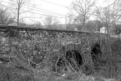
From the album: Nat'l Rd, Bank Rd., US40
I believe the road originally went to the left of the church, instead of the present path to the right.© Warren Jenkins, 2001
-
-
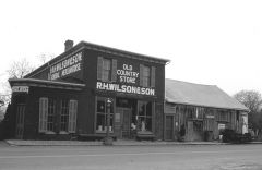
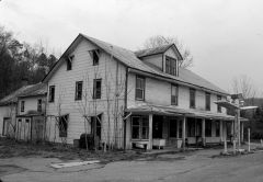
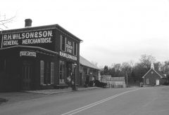
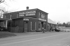
From the album: Nat'l Rd, Bank Rd., US40
Traditional country store still open to the public.© Warren Jenkins,2001
-
Photos of this sign, along with other Sideling Hill west slope scenes in B&W are posted in the member's gallery. I should mention that I do have color shots of many of the scenes and can scan them for future presentation if desired.
-
National RD., Sideling Hill's west slope; 4/04
Texaco Fire Chief added images to a gallery album in Member's Gallery
B&W photos of "forgotten" alignments,etc. of the west slope of Maryland's Sideling Hill -
-
bottom of Sideling Hill looking back east
Texaco Fire Chief posted a gallery image in Member's Gallery
From the album: National RD., Sideling Hill's west slope; 4/04
Sideling Hill Creek (a popular trout stream) 1930 bridge in foreground, old bridge abutment on right. Straight path of road was result of 1930 project; evidence by Busta-peck and others suggest a zig-zag path down to the creek crossing.© Warren Jenkins, 2004
-
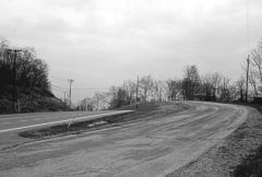
From the album: National RD., Sideling Hill's west slope; 4/04
This is the lower U curve area on Sideling's west slope, this is probably the 3rd or 4th incarnation here, and was even sharper in earlier years. The tourist cabins on the curve are quite interesting, but should be photographed from a distance to respect private property. I always get a "strange" feeling in this area, it is really kind of spooky.(Ghosts of travelers past?) After all, this little place has been bypassed twice!© Warren Jenkins, 2004
-
From the album: National RD., Sideling Hill's west slope; 4/04
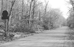
This shows the area of the previous 2 posts, the sign, Hixon's, and up to the end of driveable pavement. According to Busta-peck there may be an earlier alignment to the left up in the woods.© Warren Jenkins,2004
-
From the album: National RD., Sideling Hill's west slope; 4/04
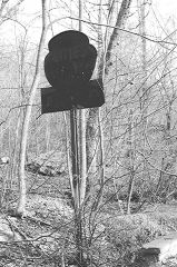
A couple hundred feet west from Hixon's is this metal sign. In 2004, it was still intact and somewhat legible, however on Busta-peck's site, his photo back in 2008 shows this sign heavily damaged Question is, was this for Hixon's, or another place further up the grade or at the summit?© Warren Jenkins,2004
-
From the album: National RD., Sideling Hill's west slope; 4/04
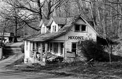
This ended its days as a feed store, however it may have been the "Cities Service Ahead" that was advertised on this segment. This area was known as "Forest Park" on old maps.© Warren Jenkins,2004
-
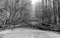
From the album: National RD., Sideling Hill's west slope; 4/04
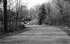
This is IMHO, a haunting view of the former NR/US 40 alignment heading up the west slope, abandoned since the late 40's. Mom nature has done an effective job of limiting access to the approx. half-mile segment. Hixon RD. (the active part of the old alignment) makes an extreme bend to the left and goes steeply uphill to meet the 1940's alignment.© Warren Jenkins, 2004
-
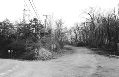
From the album: National RD., Sideling Hill's west slope; 4/04
Intersection of MD. 144 and Riser RD. (old NR alignment) at Sideling Hill summit. NR original route went up hill and curved sharply left (Riser rd. turns right), meeting the 1940's U curve about 2/3 of the way thru the bend, and about 25-30 feet higher up. When heavy traffic started using US 40/48 again in the 70's, this became a "terrifying" piece of road, with many bad wrecks until the big Sideling Hill Cut was opened in 1985. The private residence which is out of sight to the right is on the location of a once popular overlook/knick-knack stand, it had powerful binoculars where for .50 you could step up on the mounted binocs and peer far west (usually into the haze,lol). All of the businesses on this alignment died after 1985.© Warren Jenkins,2004
-
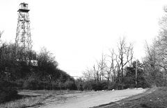
From the album: National RD., Sideling Hill's west slope; 4/04
Original summit crossing and U curve remnant. US 40 cut and curve (1940's) just beyond brush line at left. Fire tower is a long-time landmark, it was manned during fire seasons until a few years ago. Traveling the 40's alignment was bad enough in the 60's and 70's, standing on this abandoned portion gives a little perspective to the progress of travel... Kodak T-Max400© Warren Jenkins,2004
-
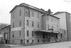
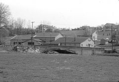
Top photo is Denny Gibson's Bottom photo is dated 1962 and is courtesy of the Frostburg Museum, of which I am a member. The auto dealership was gone by 1970. and it was used for storage until conversion to a hardware store in the early 90's.
-
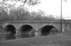
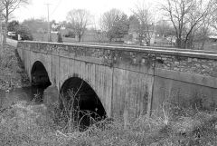
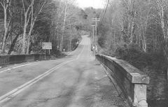
Wilson Bridge, April,2001
Texaco Fire Chief replied to Texaco Fire Chief's topic in National Road / U.S. 40
The first 10 posts to my B&W National RD. gallery have been made, with additional entries to come. Other new gallery albums are also on the way! Warren Jenkins -
-
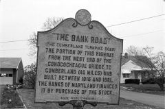
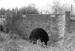
From the album: Nat'l Rd, Bank Rd., US40
Sign explaining the "Bank Road" from Baltimore to Cumberland, easternmost link to the National RD.© Warren Jenkins,2001