


Chris Rowland
-
Posts
294 -
Joined
-
Last visited
-
Days Won
1
Content Type
Profiles
Forums
Gallery
Blogs
Calendar
Posts posted by Chris Rowland
-
-
I've wondered if I could rent a camping spot and just sleep in the back of my station wagon, no tent. jim
You can definitely rent a camping spot and sleep in your car. We've done that before.
If you would like the experience of camping without the tent or an RV, I highly recommend the KOA Kamping Kabins. They are wonderful. The past two summers, we planned long road trips where we were in a Kabin one night and a hotel on alternate nights. The Kabin has one full size bed plus bunk beds, and they supply a durable, not particularly comfortable mattress-like mattress. You bring all of your own bedding and use the bathhouse just like tent camping, with the advantage that you don't have to put up or take down your shelter. This is good when you're hoping to get on the road early or arrive late. We often stay a different place each night, so the setup (not to mention finding room to transport the tent and accessories) is too difficult.
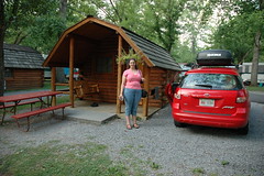
The Kabins are usually under $50 most places, and you can find them at campgrounds that were 'formerly' KOA that have gone independent, too. They worked well for our family of four. This photo is from one we stayed in at Pigeon Forge, TN last summer.
By the way, at least half of the campgrounds now have wireless internet, so you can keep us up to date on your trip progress!
Chris
-
Oh no! My secret is out!
Chris
-
I mentioned earlier that I was being filmed back in December for Across Indiana, featuring my quest for Reuben sandwiches. I promised to point you to the clip once it was posted on-line.
Here's the official "Reubenator" clip now posted on WFYI's Across Indiana archive:
Episode 1808: If It's Tuesday, This Must Be Reuben
The video should stream in newer version of Windows Media Player.
The restaurant we ate at was The Tie Dye Grill on Shadeland Avenue in Indianapolis (at one time Indiana state road 100). I recommend the Reuben there, by the way.
The whole experience of the camera crew and interview was a lot of fun.
Enjoy!
-
Weekend of:
March 29: Good
April 5: Good
April 12: Good
April 19: Bad
April 26: Good
May 3: Good
May 10: Bad (Mother's Day on Sunday!)
May 17: Good
Also, there is a free site that my friend uses that is really good for setting up this type of meeting: Meet-O-Matic He recommends it because it compiles the data nicely for you.
I don't care which direction we travel as long as Sunday morning I don't have to travel too far from Indianapolis to join everyone.
-
I think my favorite part of the Madison State Road trip was the Friendship Road (Drive?) segment where it disappeared under the fill of US 31. Was Friendship Rd/Dr ever part of US 31 or old SR1? I'll bet that 1911 Scarborough could have told us.
I partially used KTSOTR's 1916 Scarborough instructions, but the routing around Taylorsville is very confusing. I think Friendship Drive is newer than that time period. I thought the curious part about that road was that right before its southern terminus at 600N and US-31, it is carried over a bridge that is twice as wide as the road. Did you notice the width of that bridge? My thought is that the bridge was built that size to carry US31, but after the bridge was built they decided to bypass Taylorsville altogether.
I believe that what the 1916 Scarborough actually describes is that what is labeled "Tecumseh Street" in Taylorsville actually continued due south along the section line to 600N and then turned east back to the tracks. Here's what it says approaching Taylorsville: "15.5 Taylorsville. Main part of town just ahead. Turn right (south) [My guess is that this would be turning right on Tecumseh from 650N]. 16.0 Turn left (east) [i think this is turning left onto 600N since it's .5 miles later] 16.1 Turn right (south). Railroad and trolley on left. Parallel same 2.6 miles. [This would be about where Friendship Road gets buried under US-31.
Chris
-
I followed Chris Rowland's Madison State Road directions on the way down. That was an excellent drive. I loved the old-alignmentyness of it. There was even a short one-lane segment.
I drove the Michigan Road home. It is extremely twisty and hilly in Madison. Here's video.
jim
Jim, I'm glad my directions didn't get you lost.
 It was kind of fun to make them as much like the old ABB-style as possible. It would be awesome to have modern turn-by-turn directions of many of the old highways available on-line someday.
It says your video is a private clip, so I wasn't able to see that awesome hill. I was wanting myself to stop somewhere and get a photo along that hill, but I couldn't find a good place to pull over at the time.
Chris
-
Does anybody have a problem with the weekend of May 3-4?
May 4 works for me. I'll just need to know where to meet at what time that Sunday morning.
Chris
-
If you and Chris both go, I'll drive my Matrix wannabe and we'll have a fleet.
March 1-2 and April 19-20 do NOT work for me.
I can't do the Saturday portion, but would love to join you enroute bright and early on Sunday morning if all works out.
Pick a date soon so we can plan around it.
Chris
-
To find out about this, plus an abandoned bridge, 10 miles of abandoned brick highway, and an 1830s stone arch bridge still in use, read my report:
Jim, this was wonderful to go through. I'd have to say the picture of the Matrix on the brick road is my favorite. It was enjoyable to follow along.
Chris
-
Did you find, as I often do, that the post-trip research revealed things worth a return trip?
Keep the Show on the Road!
Dave
I certainly did! Thanks again for the excerpts from Scarborough and other guides. I enjoyed matching them up against some of the historical Indiana maps and atlases available on-line at the IUPUI site.
Chris
-
When posting to an existing topic, we can ... be nice, we can certainly live without ... you ... You .., of course, ... a dufus ... might ask ... a good question. I've seen ... Becky's ... superpowers ... just fine.
I usually try to keep the original intent when I trim a quote. In this case, however, I am demonstrating how not to do it.

Quoting only the particular part you are responding to makes it much more meaningful.
Chris
-
I wasn't aware that SR 37 ever went this way. I knew it followed Bluff Road out of town. About what timeframe did it follow the Madison/31 corridor?
jim
SR 37 followed US-31 from 38th Street to the south side as its most recent routing until it was routed completely around I-465 the same time that Binford Boulevard came about, which was just a few years ago. IN-37 was routed down Madison and then down East Street to I-465 where it traveled west two miles on the interstate to the Harding Street exit where it currently goes south.
Chris
P.S. Loved the micrometer tombstone.It was cool that you can see it as you drive by, without slowing down, if you want to. It really stands out.
I'd like to take my wife back to Columbus to show her some of the other architectural sites around there. I kind of piqued her interest.
Chris
Great write-up and loved the pictures. Another road tripper with the talent of bringing the reader along on the trip.I really enjoyed coming back home and doing research on the things that I saw. I thought adding some of that detail in-line livened it up a little bit.
Chris
-
I completed posting the trip album for a trip my wife and I took last month to Madison Indiana. The route we took was along a route that used to be called the "Madison State Road" and was completed in 1824. From the first page, you can follow a link to some turn-by-turn directions I created if you want to follow the route yourself.
I was somewhat inspired to take this trip because my wife ran into a man in the grocery store who stopped her and started talking incessantly about how the "Madison State Road" was really the "Mother Road" of Indiana. A good percentage of the early migration to Indiana came to Indianapolis on this route from the Ohio River. In later years once river traffic was not as important, I think the National Road surpassed it in volume.
Anyway, I hope you enjoy the trip!
Chris
-
And Dave, I know that gals sometimes date guys because of their cars but I have a strong suspicion you may have been dating your companion for her hat. I know I'd have found it hard to resist.

I wasn't sure whether that was a hat or a lampshade

Chris
-
How about listing what is evidently different about this 1965 scene of auto travel compared with today, and what do you see that is of particular interest.
The first thing I noticed is it seemed like there was no yellow stripe along the left side of the pavement. Perhaps this is due to the color quality of the film, or perhaps they didn't do that as a rule back then. That was before my time, so maybe you can enlighten me!
Chris
-
Just checking in with everyone here in the midwest to see if everyone made it through this storm OK.
It was quite an interesting front that came through Indiana last night. My wife thinks I'm crazy because as the wind would gust past our house I was watching the water in our toilet bowl start sloshing around from the changes in pressure somewhere. Well, I thought it was interesting.
I've kind of come to enjoy the unpredictability of the weather in Indiana--you never know what it will do next week.
Chris
-
I'll remember to follow the mileages when I try this in the future -- they really do seem to unlock some of the mystery.
Looks great, Jim!
-
Look for the blue placemarkers, which note the endpoints and places where I had to make judgment calls as I interpreted the ABB.
Here's detail of an atlas at IUPUI of Rochester City. You put the marker at the right corner for the jog right and left, after all. Check out how sharp the corner was in the bottom right of this image south of the corner of Peru and Perry:
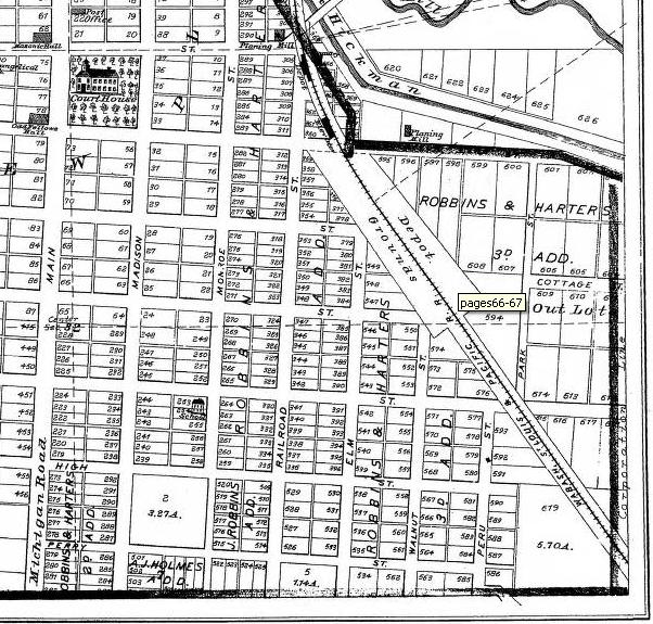
Even the name of the street "Peru" gives an indication that it was probably the way to head toward Peru Indiana.
You can still see the small jog on Google, but this map really delineates it. I'm not sure why the ABB calls it Wabash, but maybe it was called that at that time. Definitely Wabash is on "the other side of the tracks" these days...
Chris
-
I got everything but the stretch between Miami and Kokomo.
Here's your solution for Miami to Kokomo. Using the mileage really helps. Using the knowledge from my previous comment that we are in Miami at 200W and 1050S, the even mileage should make it apparent.
at 77.8 you "turn right with poles" onto 1050S and follow one mile west to what is now US-31 (300W)
at 78.8 the 4-corners is 1050S and US-31 (300W). Turn left, which is south on US-31.
at 80.0 the 4-corners is 1250S (IN-18) and US-31 (300W). Turn right, which is west on IN-18.
at 81.7 the 4-corners is 1250S (IN-18) and 400W. Turn left onto 400W.
at 84.7 the end of road is the corner of 450N (US-35) and 100W (400W turned into 100W as it changed counties), this is still an end of road today! It says to turn left on US-35 east and then right on the next street, onto 80W heading south.
at 86.4 the end of road is the corner of 300N and 80W, this is still an end of road today! It says to turn left onto 300N (east) and then right on the next street which would be onto Webster Street, heading south.
This hooks up perfectly with your other endpoint on Webster in Kokomo.
Hope this helps solve the mystery between Miami and Kokomo!
Chris
-
Look for the blue placemarkers, which note the endpoints and places where I had to make judgment calls as I interpreted the ABB.
jim
Jim, Your questionable point in Bunker Hill at 74.6 where it says to jog left and then right is the intersection of Elm and Washington--it looks more smoothed out now than it probably was back then. The hint is to look at the mileage showing it is .2 miles south of Bunker Hill (74.4), and this is about that distance south of Broadway.
However at 75.0 when it says "Turn right" you accidentally turned left on 800 South. Fixing that will mean that later at 75.4 when it does a "turn left" along the telephone poles, it should actually be turning south onto 200 West (which is .4 miles west of Elm). This fits a lot better also with the next instruction saying that the road ends on the edge of Miami, which 200 West does but 150 West doesn't stop there.
I'll look at the other questionable parts too and if I have any bright ideas, I'll let you know.
Chris
-
I use Google and Live when I'm at the computer, but in the car I want paper, period.
Paper doesn't require rebooting! I can't count how many times my GPS stops responding...
I use a GPS mostly to record latitude/longitude for later geotagging (meaning when I stop the car to take some photos, I record the location on paper). I almost always know my route in my head and have paper maps along for that type of planning.
Chris
-
Unfortunately for Metro Graphic Arts, of Grand Rapids, they seem to be headed the way of the buggy whip and the typewriter.
My first map was a Fred F. Johnson... In 1976 I was 4 years old when my dad gave me his 1972 Fred F. Johnson map of Indianapolis (in Convenient Book Form). I started tracing our route to church and to grandma's house on that map... So this one's a little sentimental for me.
Chris
-
My little red 03 Matrix just rolled over 70k. I'm hearing the noise of a throwout bearing that is nearing the end of its life, which usually means it's time for a new clutch, too. Whee. Oh, and I have lost six wheel covers now. Toyota charges $80 apiece for them. I've finally decided I should just put $80 rims on the car and be done with it!
Why did you have to say that about wheel covers! We hadn't lost any until my wife lost our first one this week. I hope your premonition about your clutch is not contagious, also. I don't want any problems like that. As far as the wheel cover, I don't think I'm ready to shell out $80... not sure what I'll do yet, if anything. Hey, if you get those rims, I might be in the market for some "used" wheel covers from you.
Chris
-
I hope you enjoy them.
Great photos! I really enjoyed the slideshows. I also watched US-36, another favorite of mine. This summer, it looks like I'll be taking US-52 from the Saskatchewan border to Indiana--too bad you haven't been there yet so I could get a preview...
Chris
Camping?
in RV & Camping
Posted
Trail 3 rules!!!!!!!
Chris