


Chris Rowland
-
Posts
294 -
Joined
-
Last visited
-
Days Won
1
Content Type
Profiles
Forums
Gallery
Blogs
Calendar
Posts posted by Chris Rowland
-
-
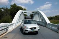
I think you are on to something there! What is the shape of the Cities Service Logo? Is it a triangle in a circle, and the "arrow" is their logo?
Keep the Show on the Road!
Were you not able to see the image in my reply? Here's a close-up,

or you can follow this link: Cities Service Logo
I thought of it because I have a road map they distributed with their logo on the top. It's an H.M. Gousha 1959 map of Baltimore Metropolitan Area.
Chris
-
My interpretation, of course, may be wrong. I know this much of the text with certainty:
(>)
CITIES
S
A D
I'd love to hear any other possible guesses / thoughts.
Are you sure it couldn't just be an advertisement for "Cities Service" ahead?

The curvature of the "Cities Service" station logo is similar to the curvature of the sign.
What do you think?
Chris
-
Click HERE for the video.
I enjoyed your video--it's been four years since I'd seen Multnomah Falls. It is a bautiful area.
How do you take the video while you are driving on some of those curves? Do you have the camera mounted or use an assistant? Or are you just highly talented?
Chris
-
One of it's side paths concerned geotagging and some free software called Location Stamper (http://wwmx.org/). Since then I've been geotagging with abandon and my Garmin.
I've begun looking into this too. I haven't tagged any of my photos yet, and my biggest concern right now is selecting the right tools to use to tag my photos, both the captions and the geotagging. I downloaded the wwmx stamper a week or two ago, but I wasn't sure how it was storing the info. Does it store the coordinates in the same place that Picasa does with the same EXIF tags?
My big fear is to spend weeks tagging photos with one tool that becomes obsolete and stores the tagged info in some header that no other tool uses. I want to make sure it's in some sort of "standard" format so my time spent won't go to waste--I'd like to make sure that software I'm using 20 years from now will see and recognize those tags for what they are.
I assume you are tagging with WWMX--what other tools have you successfully read those tags out with?
Chris
-
Day one is up and the rest will follow with a day (or so) lag at
I've enjoyed days 1 and 2 so far. The photos from the Federal Highway sure make Alabama look quiet and deserted... But I guess Sundays are like that in the South unless you are near a church?
Chris
-
Or perhaps...
L'Americaine Rue Brew
"Rue" is more like a street whre "route" would be like a road or highway.
If going for French, I would suggest simply American Road":
"Route Américaine"
Chris
-
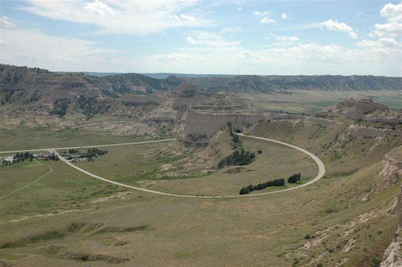
This is Scotts Bluff, the closest town being Gering, NE, in the County of Scotts Bluff, near the town of Scottsbluff., in the Nebraska Panhandle. Most times of the year, you can drive up to the top of the Bluff!
(Yes, they are inconsistent in the spellings!)
Oops. The State Highway in Nebraska 92 running west from Gering.
You got it, Larry. I took the photo from a nice view point within the park at 41.835,-103.700 looking southwest, where you can see the park entrance and visitor center off of Nebraska 92. I love the arc in the park road and how it curves up into the tunnel that gets you to the back of the ridge to make the rest of the ascent up Scotts Bluff. It was named for Hiram Scott whose skeleton was found there about the 1830s--kind of a mystery as to what really happened to him.
Chris
-
I think that is the station near Sutherland.
Never been there, but it is in the historical inventory of Lincoln County, NE.
Dave
Dave, how did you ever do that? I am amazed that you could look at that building and figure out where it was. I did find the reference you were referring to and put it here so we could all see it.
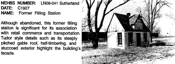
This photo from the inventory looks like a train behind the station--I tried looking at the satellite photos of the Sutherland area and couldn't quite place it. It's a pretty small building under a tree, so it might be impossible to spot.
Chris
-
I’m thinking this must be a site along the old Oregon Trail..
The photo locale is definitely within 5 miles of the old Oregon Trail.
Chris
-
This is a photo that I took at a famous Nebraska landmark. There is a state highway running across the middle of the frame, coming in from the left and vanishing in a pass between the cliffs. Name the landmark, provide the number of the Nebraska state highway, and preferably the latitude and longitude where the photo was taken.
This one might be easy, but I can give more hints if it is too difficult.
You should be able to click for a larger image.
Chris

-
Good memory...that is the Green River...and the key question is what is the name of the rock (and/ or the coordinates)?
Keep the Show on the Road!
This is Tollgate Rock, probably taken in the 1930's. I'd say that the photographer was standing at 41.539, -109.482, shooting the photo NNW.
I did find a more recent photo from almost the same spot:
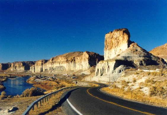
I should have guessed Green River earlier... we drove right by that rock last summer on our Wyoming trip, and my wife and I were married in Green River in 1995. Her family lived just down the road in Rock Springs at the time. That's really the only region of Wyoming I'm much familiar with, being a Hoosier.
Thanks for the challenge!
Chris
-
This is a landmark along a highway in Wyoming. Name it, and provide the location and name or number of the highway, and preferably the latitude and longitude.
I think perhaps you're asking a little too much on this one... I'm assuming that's a river on the left and there's a big rock. Maybe a town on the left side where the road goes to a vanishing point?
Unfortunately, most maps and aerial photos won't be helpful in finding that rock configuration. It's also such a small piece of road, that I'm not sure how to track it down.
Do you have any clues at all to help narrow down what part of Wyoming this might be? Right now this seems impossible.
Chris
-
Virginia City, Nevada, 1962. This is before Virginia City was restored. It was already a tourist destination, but there was little to no restoration yet.
I especially enjoyed the Virginia City footage--I stopped by there twice in the past five years on business trips to Reno. I remember going into the "Totem Trading Post" and walking up the boardwalk sidewalks that are shown in the clip. I loved taking Nevada-341 over the mountain from Reno.
Chris
-
where you should not miss
seeing Carhenge ( http://www.carhenge.com ) and then easily on to Wyoming or South Dakota!
Our family loved Carhenge last summer! Our boys were 9 and 7 at the time.

Chris
-
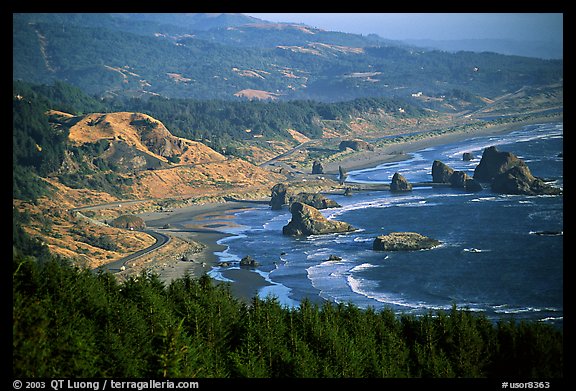
This is along the Oregon Coast, looking north on what is now US101. My guess from having driven this road several times is that it is southern Oregon. The broad clues are that the road is practically on the water and cut from the hillside. The more specific clues are in the near and far rocks...but it isn’t clear how high the tide is so who knows if the rocks will or won’t show.
It kind of looks like this angle looking toward Cape Sebastian: Meyer's Creek Beach, From Above The Coast Highway, but I don't quite think so. This is a photo kind of looking the opposite direction: Coastline with highway and seastacks, Pistol River State Park.
The road and the rock seem to match up, but the problem with this location is that I don't see where those buildings would have ever been.
I'll keep looking.
Chris
-
You or someone else familiar with this area of Washington can tell me where US 10 is in this picture postcard.
I really enjoyed the challenge of figuring out where this photo was taken. I think it would be awesome if people could post landscape pictures that had roads/buildings/rivers/mountains, etc. with just enough detail in the picture and the description so that we could search and try to determine based on maps and satellite imagery where the photo might have been taken from. This post card was a beautiful example... Is anyone else interested in doing that type of sleuthing?
Chris
-
You or someone else familiar with this area of Washington can tell me where US 10 is in this picture postcard. Is it to the right and just out of the photo? The bridge is almost certainly the one on the road into Thorp, and I assume the view is southwest along the Yakima River, west of Ellensburg.
Are you thinking that this is the bridge at (47.10098,-120.702603)? I think it matches up pretty closely. Also, my map doesn't say US-10 but a state road 10. From the image on Google I linked to, it looks like the picture probably was taken from highway 10, looking southwest as you mention.
Of course I've never been on that highway--just a virtual tourist via satellite.
Chris
-
PPS. I find the toll gates all over the place interesting! Imagine what that translated to when you tried to develop free transcontinental roads. The Lincoln Highway was touted early on as a "free road." No wonder that was a big deal!
I count at least three toll gates on that little section of map--how did those work? Were they operated by the people who lived on the adjoining parcel? Who did they give the money to? Did they have to give a portion to the county, or how did that work? I wonder what kind of an income one of those toll gates could earn someone compared to farming back then. I can see taking a toll on some of the major trails like the Michigan Road, but I can't imagine that some of those smaller county roads would get a lot of traffic that wasn't local farmers and neighbors.
Chris
-
Roadmaven, I don't know much at all about MR's route through Indy, and I'm not able to find much out there on the Net. If I were making the trip today, I'd just assume it followed the old 421 route as you describe it. Sounds right to me.
This excerpt from a map on the IUPUI server (Map) is actually labeled Michigan Road all the way down what is now MLK and West Street to what is 10th Street today (labeled First St.) on the map. I don't see any other evidence of it south of there until it breaks from the National Road. The only two logical options I can see are that it continued straight south on West to Washington or took West down to the intersection with Indiana and then headed southeast, but I have never seen that documented.
Check out the canal crossing between Fifth and Sixth streets on the map (14th & 15th street with today's numbering. Until recently I remember some strange remnants visible on the southeast corner of 16th & Martin Luther King.
Chris
-
Southern Indiana was populated first, I believe because it's on the Ohio.
jim
There are a lot of old alignments along I-74 as the Michigan Road leaves Indianapolis until it gets to Greenburg. It erratically alternates between disconnected frontage roads on the north and the south sides of the Interstate.
This brings up one of my biggest complaints about the recent interchange work at I-465 and I-74 on the southeast side of Indianapolis. Traffic on I-465 South (multiplexed with US-421 South) used to be told that exit 49 took them onto I-74 East and US-421 South. Since they put up the new signs, the route turn for US-421 has gone stealth and is never mentioned, like it doesn't exist. Isn't this against regulations (AASHTO or other) to have a route leave one highway and join another without any signage? After being multiplexed with the Interstate for 22 miles, who is going to remember what exit number they needed to turn onto? I hate how they have routed all of the US and state highways around Indianapolis, but they could at least tell you when to get off!!!
My guess is that it was either an oversight by the highway contractor doing the signs or a cost saving measure because the old sign that held both the I-74 and US-421 shields was much wider. I've tried to figure out who to complain to at the Indiana DOT but haven't had any bright ideas yet.
Back to the Michigan Road... you'll note that the old alignment cuts straight south just past Napoleon, Indiana and bypasses Versailles entirely, running along the border of the Jefferson Proving Ground. I'm guessing Versailles lobbied to be put onto the highway even though it added 2.6 miles to the route.
Be sure to plan for some time to look around Madison. Also, Clifty Falls State Park is a must-see if you haven't been there.
Chris
-
Well, good news & bad news. The good news is young Zach became an Eagle Scout recently. The bad news is the sign....well, I'll let you read about it: Bummer
That is depressing. Of course the driver's liability insurance probably won't do anything about it.
-
Would a blog and the historicroadmaps.com site be complementary?
Keep the Show on the Road.
A blog is much more like a news feed since you're basically just posting/publishing entries for people to read. You can present random material, and people are entertained by either following your life and adventures or what you have selected to share for the day. I see this much more like a virtual newspaper that you are publishing.
On the other hand, something like historicroadmaps.com is not like a newspaper but like a library. People go there to browse and probably to look for something specific. Things are categorized and organized for ease of reference.
So I see them as quite complementary. In a way, the blog could be monitored by people wanting to see what new items you are scanning and posting with a cross reference to the material actually stored and organized by state/media type/etc. on historicroadmaps.com. That's my four cents worth.
Also, I was wondering what your plans are for historicroadmaps.com. Is that something that we can add scans and maps of our materials to also? Or is it meant to be an archive of only your items? Just wondering because I had a few things to possibly share.
Chris
-
A little less bothersome is a nice piece from early in '07 on a gentleman from Gaston, IN who's a good friend of the Corvair community.
I've always thought the show does a good job in the segments they do. I am glad it is this program interested instead of the local network news--so at least it'll be a quality production. I'm curious and a little nervous about how they are going to portray me and what type of "angle" they will put to the story... We've been interviewed for magazines before, but TV is a little different. At least I plan on keeping my clothes on though, unlike the Santa segment!
The Corvairs looked awesome!
Chris
-
Regarding the TV interview....You definitely qualify as expert! Did you say what the interview is for? I mean do they plan a show on sandwiches, unique web sites, restaurants, unique interests...or ? Will it go beyond the local station? Will you get a copy of the interview to share?
Did I mention that we have more than an interest in Reubens in common...I used to teach programming...back in the really really "old days." Ever hear of the 1620, 1440, and 1401.... a whole different world! Even the old joke about turning the punch card over to use the other side gets a blank look today! A punch what?
Keep the Show on the Road!
I believe it is for their Across Indiana program, which is advertised as "Take a weekly journey across the cultural landscape of the Hoosier state. Host Michael Atwood and a team of award-winning producers explore the places, people and traditions that make Indiana a unique place to live and work. The program profiles interesting Hoosiers, from humble farmers to computer entrepreneurs and folk artists. Across Indiana blends heart, soul, humor and journalistic insight into a unique television program made by, and about, the people of Indiana."
So my guess is that they are either profiling me or my group as fitting the "interesting Hoosier" with unique interests description. It looks like they have all of the segments viewable from the web site, so once it's aired, I can point you there.
I assume those computers you mention were mainframes? IBM? The closest I got to punch cards was in middle school in 1985 our "computer" unit consisted of punching out our name on a perforated punch card. They sent them "downtown" to run them on the big computer and it produced a printout of what was on the cards. If it came back and our name was spelled right, we got a good grade. Not quite what I would call programming, though. At the time, I was programming Applesoft BASIC on my Apple ][e.
Chris
The Oldest Speed Warning Sign I've Ever Seen, Revisited
in National Road / U.S. 40
Posted
cbustapeck, next time you go by there you can look to see how far "ahead" the service station was. It could have maybe been at that tiny crossroads? Or maybe a mile or so up the road...