


rudkipon66
-
Posts
101 -
Joined
-
Last visited
-
Days Won
1
Content Type
Profiles
Forums
Gallery
Blogs
Calendar
Everything posted by rudkipon66
-
know you don't see many paddleboats on the blue highways, but the fate of the old Delta Queen gave me pause...shares a birthyear with Route 66 as well (1926)...there is a campaign to save the Delta Queen (http://www.steamboats.org/save-the-delta-queen-2007.html)... Tsingtao Kip Can the Delta Queen be saved? By Bill Lambrecht POST-DISPATCH WASHINGTON BUREAU CHIEF Sunday, Aug. 19 2007 WASHINGTON — In a campaign that stretches to the rivers of Europe, steamboat enthusiasts are lobbying to save the famed Delta Queen after Congress refused to renew a fire-safety exemption that has let it operate for nearly four decades. The elegant, multideck paddle-wheeler has plied the Mississippi and other rivers for 81 years, recalling a slower-moving era of opulence and romance. Since 1970, the Delta Queen has toured on overnight trips only through an exemption from Coast Guard regulations for vessels built primarily of wood. But this summer, the House Transportation and Infrastructure Committee refused to renew the Delta Queen's 10-year exemption when it sent a catch-all Coast Guard bill to the floor. The committee's chairman, Rep. James Oberstar, D-Minn., is adamant; he asserts that Congress has given no other boat such an exemption. "I can't imagine the number of lives that could be lost if a fire started on the Delta Queen when everyone is asleep," he said. "Congress would never exempt a particular 747 aircraft from FAA safety standards, and we should not exempt a passenger vessel carrying hundreds of sleeping people from Coast Guard safety standards." Losing the exemption would prevent the Delta Queen from running overnight cruises after November 2008. Cruises on a ship rich with mahogany and teak, adorned with stained glass and antiques and featuring fine dining and deluxe linens, are what appeal to well-heeled travelers. Bookings on a seven-night cruise from St. Louis to Nashville next year are advertised at between $2,300 and $3,600 per person for staterooms. The committee action was an early step in the congressional process. But Seattle-based Majestic America Line, the ship's owner since last year, surprised Delta Queen fans by seemingly giving up and announcing a farewell celebration for the Delta Queen next year. The boat's fate has not been spelled out. The developments have riled Delta Queen devotees as well as fans of steamboats and river culture in general. In an Internet campaign this month, they are trying to persuade Congress to allow the last overnight sternwheeler to continue. "It's a relic of American history," said Nori Muster, an Arizona Realtor whose late father, Bill Muster, led the last such exemption fight 38 years ago. "People who love the boat must rise up in a movement to save it, or at least pay for its retirement, or it's going to end up a gambling boat or something that would be sacrilegious." 'BLOOD ON CONGRESS' Whatever happens, the Delta Queen has survived long enough and with such a storied past that it is recognized as a National Historical Landmark. The 240-foot-long Queen was built in 1926 along with its twin, the Delta King, which fell on hard times before being converted to a hotel and restaurant along the Sacramento River. In their early years in California, the King and Queen were World War II military vessels ferrying naval reservists and wounded soldiers. After it was bought in 1946, the Queen made a 5,261-mile journey through the Panama Canal to New Orleans, before starting service on Midwestern rivers that continues to this day. It began landing in St. Louis in 1954, and for many years participated in an annual summer "race" from New Orleans to St. Louis with the Mississippi Queen riverboat. But in the 1960s, two incidents focused attention on the issue of cruise ship safety. In 1963, the Greek ship Lakonia caught fire on a Christmas cruise in the Canary Island, taking 125 lives. Two years later, 90 people perished when the Yarmouth Castle, a multi-wooden deck boat built the same year as the Delta Queen, caught fire on a cruise from Miami to Nassau. These disasters prompted the 1965 Safety of Life at Sea treaty, and a new resolve by the Coast Guard to enforce safety rules that required overnight passenger ships to be built with nonflammable materials. The Delta Queen would have been relegated to day cruises soon after if Rep. Edward Garmatz, D-Md., chairman of the House Merchant Marine and Fisheries Committee, had had his way. In a letter to House members in 1970 with hand-drawn skulls and crossbones, Garmatz wrote: "I hope the Delta Queen never burns. But if it does, the blood will be on Congress, not on the expert agencies which told us to stop the operation." But a campaign that included Vicki Webster, of St. Louis, who worked in the Richard M. Nixon White House at the time, along with Johnny Cash and other notables, won an exemption from Coast Guard rules. Rep. Leonor K. Sullivan, D-St. Louis, succeeded Garmatz as chairman of the House committee and fought to retain the exemption. Webster is upset now by what she calls "the stupidity of it all. It's a typical case of people wanting to be protected from Day One from harm. You might have to ride on planes and buses and streetcars from time to time. But nobody has to ride on the Delta Queen." DEBATING RISK The Coast Guard didn't support the exemption then and doesn't now, reiterating in a statement last week that the exemption would pose "an unacceptable risk." The statement adds that the Delta Queen still could make sightseeing runs and voyages without overnight guests. The vessel is subject to frequent inspections. For instance, records show that the Coast Guard found improper wiring "creating a possible fire hazard" in an inspection in February in New Orleans. It was later fixed. Majestic America Line, which has an office in St. Louis, argues that training, sprinklers and various fire and smoke detection devices provide ample protection for passengers. The company insists that it lobbied vigorously to retain the exemption and didn't declare the cause lost until Oberstar and his Senate counterpart, Daniel Inouye, chairman of the Senate Commerce, Science and Transportation, each said no. "We'd be ecstatic if someone were to carry the torch at this point," said Joseph McCarthy, chief counsel for Ambassadors International, Majestic's parent company. Thus far, efforts by Rep. William Lacy Clay, D-St. Louis, and others who have backed the exemption, have fallen short. Meanwhile, a Save the Delta Queen Internet campaign organized from Germany is picking up steam. Franz Neumeier, who started the campaign, said, "It doesn't look good at the moment." Neumeier, 38, who edits two computer magazines in Munich, spoke while cruising the Ohio River on another steamboat, the American Queen. Longtime Delta Queen fans like Beau Hampton, who has played Dixieland drums on many cruises, says he sees no valid issue based on his work on 50 vessels. "It's a joke. If a fire breaks out, you just pull over to the side of the river. It's not like we're going to sink or anything," he said. Others, like Arizona's Nori Muster, see more at stake than cruises. "Boats are my deities," said Muster. "They are symbols of something good about America. They represent innocence and progress, and they tell us a lot about human folly."
-
 Hello: Quinn, Natalie and I took a trip to Clinton OK in June to the Route 66 Festival, and after that, trekked Route 66 to Santa Fe, NM...wanted to share our travels with you all, as it was a GREAT trip, we saw a lot of wonderful things, met (and caught up with) a lot of wonderful people, and really got a chance to catch up with ourselves, we got a way from the day by day grudgeries of life and followed the creed of Route 66 travel: it ain't getting there that matters as much as what you see and do along the way! We hope that our travelogue is not too cumbersome (the pics and words are in chronological order), and hope you all enjoy it! Tsingtao, Kip, Quinn and Natalie Kay http://adobe.kodakgallery.com/rudkipon66 Enjoy! Tsingtao, Kip
 -
On Saturday, we took a trek down Highway 61 to see the Welborn Clan at the Cave Winery near Ste. Genevieve. MO. A little wine, a little fellowship, and a lot of fun! http://www.kodakgallery.com/rudkipon66 Tsingtao, Kip
-
Neat Logo! Tsingtao Kip
-
Quinn, Natalie and I recently made our Easter trek up to Northern Wisconsin...enroute we were able to take some of US 51, which is very well promoted these days in Wisconsin with the "Explore US 51" program...when we got to Portage, we stopped at an excellent little greasy spoon called the Levee Restaurant...it is an old truck stop from the 1940's, and the interior looks like it hasn't changed much from that time...the food (we had breakfast) was fantastic, and, from the pies sitting on the counter, it looks like they have some great pie! It is named for the Wisconsin River Levee which is right across US 51 from the place...It is a great place to stop taking your "highway 51" trip, and I recommend it (and taking US 51 from the IL border to Portage and points North...Tsingtao Kip
-
Hello All: The ML baseball season starts this weekend...and what better time to think about how you are going to end the season than now? And what better way to get ready for the playoffs than with the Missouri Route 66 Motor Tour, this year highlighting the Routes baseball Heritage, from Mickey Mantle's early days in Oklahoma to Sunny Jim Bottomley's final resting place in Sullivan, MO...below is some scoop from the "hot stove"...hope you can join us! as Jack Buck would say: thankyouforyourtimetillnexttimesolong! Kip Welborn, cochair, motor tour committee The Route 66 Association of Missouri will again be cruising the old highway on their 18thAnnual Motor Tour, to be held September 7, 8 and 9, 2007. The Tour will commence in Miami, OK and end in Sullivan MO. This years theme is "Take Me Out To Our Highway". The tour will celebrate not only Route 66, but its baseball tradition--from Mickey Mantle, who was born just north of Miami, OK, to Mickey Owen, to "Sunny" Jim Bottomley, who died in Sullivan, MO. Tour registration commences at 4:00 p.m. on Friday at the Best Western Inn of Miami, in Miami OK, where a block of rooms has been set aside for tour goers. That evening, there will be activities for the participants, information on which will be available at registration. On Saturday the Tour will go as far as Springfield, MO. There will be several stops along the way, including Mickey Mantle’s boyhood home in Commerce OK, the old Phillips 66 gas station in Baxter Springs, KA, and the Mickey Owen Baseball Camp outside Miller, MO. The Tour will make its midpoint stop at the Best Western Route 66 Rail Haven in Springfield, where a block of rooms has been set aside for those on the tour. That evening there will be some fine Bar-B-Q served up by Buckingham’s BBQ for participants at Smith Park in Springfield. On Sunday, after the nondenominational worship service, folks will be able to enjoy Route 66 in Missouri enroute to the tour finale at Jim Bottomley Park in Sullivan, MO. Information on any planned stops or activities along the way will be made available at registration At Jim Bottomley Park, tour goers will be able to enjoy a picnic lunch served up by Caterer, Inc., and "chew the fat" with fellow roadies to end the Tour. Jim Bottomley’s grave is astones throw away from the park, at the IOOF Cemetery in Sullivan. Additional information on any planned stops or activities along the way will be made available at registration. Here’s hoping you can join us on our trek down the old Highway! For more information, contact Kip Welborn at 314-776-7385 (rudkip@sbcglobal.net), or Jane Dippel at 314-843-7132 (vestaon66@cs.com), or visit our website at www.Missouri66.org.
-
See the attachment below about the exploits of mahself, Quinn, Natalie and Robert Shulz to find the biggest homage to the Beer that made Belleville Famous--also to find a wierd kink in the history of US 67 between Alton and Carrollton, IL: http://www.kodakgallery.com/rudkipon66 Tsingtao Kip
-
Just a note for those thinking about taking the Dixie Highway Cruise: Hy 62, which runs from Dale IN (a few miles S. of Interstate 64 (exit 57) to New Albany, IN, is a beautiful drive along the Ohio River Scenic Byway...I remembered this when we did our sweetheart cruise and we stood on a bluff overlooking the Missouri River...there is a very similar lookout overlooking the Ohio River just outside Leavenworth IN...you also pass through a very pretty little town called Corydon, the first state capital of Indiana, and just east of Corydon, a newly painted Red Pouch Chewing Tobacco sign on a barn! It is a really neat trek and a nice addition to any cruise! Just a pointer! Tsingtao Kip
-
Sweetheart Cruise Down The Booneslick
rudkipon66 replied to rudkipon66's topic in National Road / U.S. 40
I don't think Carolyn will mind--it was part of the trip and she is the good natured type! Tsingtao Kip -
On February 17 and 18 six cruisers from St. Louis, Kent and Mary Sue Sanderson, Carolyn Hasenfratz, Quinn Grimes, Natalie Kay and myself brave the elements to take the old Booneslick Road and old US 40 from St. Charles, MO to Boonville, MO. The Booneslick Road was a conduit between the old National Road and the Santa Fe Trail, which began in St. Charles, MO and ended in New Franklin, MO. The Cruise started out at 9:30 a.m. at the Southeast Corner of the old St. Charles County Courthouse, at the marker commemorating the start of the Booneslick Trail. The weather was slightly ominous, complete with blowing and drifting snow, but hey, we aren’t armchair roadies, are we??? From the Courthouse, we connected with the Booneslick Road, passing the old Western Motel and the Booneslick Inn. From there we cruised through St. Charles County, enduring the pox of suburbia before passing through the cute burg of Cottleville on CR N, and then passing through some fine scenery in the west part of the county. We trudged forward through the snow on CR MM to Warrenton. The Booneslick Road went right down mainstreet Warrenton, a fine little place with an old movie house. We rounded the “new” courthouse, to find, right across the street, the dome of the old one; a strange site to say the least!. Just west of Warrenton, the Booneslick Road connected with Old US 40. We followed the route west to Jonesburg along I-70. Jonesburg has a neat little downtown and a place called Frumpy Joes, an eclectic eatery where “the locals eat”. Downtown Jonesburg is also home to a fine little saloon that Kent highly recommends for their “home put together hamburgers”. From Jonesburg we crossed over I-70 on “Spur CR Y” (thats a new one)to the North Outer Road for I-70. Once on the North Outer Road, we reconnected with Old US 40 and cruised to High Hill. High Hill gives new meaning to “the place that time forgot.” Enroute into High Hill you pass the old Stuckeys and Nickerson Farms that used to be mainstays along Interstates across the Country. The condition of the old Nickerson Farms clearly indicates that its day as a “mainstay” has long since past. When we got to High Hill, we passed a sign that said “Historic Town for sale”, and an old Deli/antique store that Kent and Mary Sue recommended. Alas, the place has been out of business since October, 2005. From High Hill we cruised west on Old US 40 (North Outer Road), passing the great purple water tower in New Florence. The route passes a mile or two south of New Florence, but if you are passing through and you are hungry, you might want to check out Maggies, an old school truck stop restaurant, right on Old US 40 just west of SR 19. From there, we trudged on to Danville, home of Graham Cave State Park. The snow made things a little interesting when we got to the Park. The Park was closed, and as we attempted to turn around, I got stuck in the snow. After a little pushing and help from a towel provided by Carolyn, I got back on the road and headed out of the park. Unfortunately, Carolyn also got stuck at the Park. After almost getting stuck again, we returned to the scene of the incident and, along with Kent and the park personnel-- who were very nice and very helpful, we got Carolyn out of the snow and headed back to Old US 40. Road and weather conditions required us to get onto I-70. We took that a few miles and got off at the Williamsburg exit (exit 261) and got back on Old US 40 (North Outer Road). Williamsburg clearly used to be a great wide spot in the road; you can still see remnants of old gas stations and a motel. While much of the old town is gone, Crains Grocery and Marlenes restaurant are still there. We had lunch at Marlene’s–some good grub served by some very nice people–and took in the little museum that was there, complete with stuff of the past and a little collection of bobblehead dolls. It was a cool little stop for a cold winter day. From Marlene’s, we headed west out of Williamsburg on old 40. The weather had been up and down all day, but the road and the conditions were definitely a bit harrowing for a few miles. Nonetheless, we made it to CR Z, where the Booneslick Road veers south from old US 40 and heads SW to Fulton. Fortunately, all the snow had been removed from CR Z, which made for an easy cruise to Fulton. Fulton is home to Mary Sues alma mater, William Woods College, to the Winston Churchill Memorial, and to a very nice little downtown. It was also the where we found the first easily accessable DAR marker on the route. The DAR markers commemorating the Booneslick Road are located all along the route, marking places which the road passed during its heyday. From Fulton, we headed NW on CR F, which became CR WW outside Millersburg, and on into Columbia. Columbia is the situs of MY alma mater, Missouri University, and my favorite poolhall in the whole world, Booches. This is an old school poolhall. It is dark, grey, and looks like a smoke filled room without the smoke. There is a line of pool tables going from one end of the place to the other, and there is a wonderful Stag Beer sign hanging on one wall. We got a table (a 9 footer, which impressed Kent all over the place!), and we got a couple of games in for free. By this time the troops were slightly road weary. We got on I-70 West and took it to where US 40 veered off toward New Franklin and Boonville (exit 121). It is a beautiful drive, and when you come down from the hills to the flats (especially with everything–including the roads–covered in white), you wonder whether or not you are driving into the river. We cruised through this fantasyland till we reached the Missouri River Bridge, crossed into Boonville and went on to our Hotel, the Days Inn in Boonville. The Days Inn was a very nice place and the folks were quite accommodating. Natalie got a chance to get her ya yas out at the pool and the rest of the crew spent the evening eating pizza, rapping about road trips of the past and ones we have yet to take, and I learned about Chrome Duct Tape, which might don my PT someday. My thought had been to eat downtown at an old roadside attraction, the Stein House Café. However, times spent with friends, no matter where you are or what you are eating, are priceless. The next day, we ate breakfast at an old friend–the Bobber Truck Stop (across I-70 from the Days Inn on CR . It was good to see that the Bobber chain is still around. The one in Sullivan, which we stopped at frequently, was knocked down so they could build a shiny new convenoplex. I would, however, say that ordering off the menu is probably the way to go–the breakfast buffet was OK but nothing special. Right across the street was a cute little mom and pop motel called the QT Inn. I had thought about staying there but did not know anything about it. Now that I have seen it, I can say it is definitely worth a look! From the Bobber we went into Boonville, which is a sweet little town. It is where the KATY Railroad (of KATY Trail fame) crossed the Missouri River, and is apparently where the Presbyterian Church split over the issue of slavery (this according to a very nice lady who caught us on the street and brought us to her church for a spontaneous tour of a VERY lovely building!). The Presbyterians, according to our guide, did not reunite until 1985. Boonville has a nice downtown, home of the Thespian Hall (the oldest such venue west of the Mississippi), the Stein House Café, and lots of great ghost signage! From downtown we drove to the KATY Railroad Bridge across the Missouri River, which, despite the efforts of the owners to sell it for scrap, is still standing. Thanks to the Isle of Capri Casino’s parking facilities, we were able to park right next to it. It is raised up to allow for river traffic. Right nearby is the Boonville Train Station, which is magnificently restored–easily one of the coolest train stations you will find anywhere! From Boonville, we crossed the river and headed for the “end of the road”, New Franklin, MO. Actually the Booneslick Road originally ended in what was Franklin, MO (in the 1820's one of the largest towns in Missouri) but the town was relocated to New Franklin due to flooding. Coming into new Franklin, we were introduced to a very cool bridge that took SR 5 across the railroad, which was built in 1940. From there, we proceeded to downtown New Franklin, where we took stock of the cute little town and saw the marker commemorating the start of the Santa Fe Trail. As for the end of the Booneslick Road, it is marked by a very tiny piece of rock at the base of the back of the Santa Fe Marker and is barely even visible anymore. We had to do a little digging to expose it! From New Franklin, we proceeded back to US 40 and headed East to Rocheport (just off US 40 on “Spur” SR 240), home of Les Bourgeois Winery, one of Missouri’s larger wineries. It is located on a bluff above the Missouri River, and you can get an amazing view of the river from there. Rocheport is an eclectic place; we stopped at an old drug store that had everything from eggs and bread to herbal teas... From Rocheport, we proceeded back to US 40 and headed East, and ended the tour at the Midway Truck Stop at the intersection of US 40 and I-70. From there, we bid our adieus and went our separate ways. I think I speak for the group in saying that I am glad we weathered the storm and cruised the Booneslick Road, and I would recommend this trek to anyone! Pictures to go along with the Narrative can be found at: http://www.kodakgallery.com/rudkipon66/mai...art_cruise_2007 Tsingtao Kip
-
On Valentine's Day, Quinn and I ventured to a great new joint in Webster Groves, the Highway 61 Roadhouse and Kitchen...the place is chock full of murals, photos, and memorabilia commemorating the "blues highway"...the food continues that commemoration; we had Fried Tamales (a Delta favorite) and I had BBQ Spaghetti (Spaghetti saturated with jerked pork and the Roadhouses own BBQ sauce--have your Tums by your side for this one!). They also served Quinn and I heard some great music (it was a benefit for Katrina Relief, and all the proceeds go to New Orleans)...you can hear great blues there as well (Kim Massie, an icon of the St. Louis Blues scene, plays there regularly)...it is sorta strange touting a "Route 61" roadhouse that is not quite on highway 61, but if you are visiting the St. Louis area, it is well worth the visit...it is located at 34 S. Old Orchard (just off Big Bend) in Webster Groves, Mo...for more info, visit their website www.hwy61roadhouse.com...Tsingtao Kip
-
For those of you not on the 66 Egroup, Rod Harsh posted a ditty about efforts to make the "ribbon road" between Miami and Afton a scenic byway...here is the post: Hi Group, I just posted this video clip of tonight's local news on Google Video: http://video.google.com/videoplay?docid=-7365393451188411565 <http://video.google.com/videoplay?docid=-7365393451188411565> regarding the "Ribbon" road, a one-lane stretch of 66 just south of Miami, OK., and that town's interest in becoming Route 66 Pro-Active by erecting a monument downtown to recognize The Mother Road. This clip should be shown to communities that are slow to jump on the Route 66 bandwagon. The message: "If you don't start soon, you will be competing for Route travelers in other nearby communities". Thanks. Rod
-
Phil Patton, in his book "Open Road" homages the Dixie Highway: "Carl Fisher was one of the founders of the Dixie Highway Association, touting "your favorite route 6 and from Florida to the Great Smokies". Marked by red and white blazes on telephone poles, the Disie Highway ran from Bay City, MI, through Chicago and Cincinnati, into Kentucky and Tennesseeand around the peninsula of Florida in a great loop. It helped sustain the Floirda Land boom of the twenties--Fisher was also the prime mover behind the devlopment of Miami Beach--and it boosted local sights along the way. Dixie Highway maps advertised Florence, Kentucy as "the site of John Lloyd's famous novel "Stringtown on the Pike", highlighted Jellico, Tennesee, as the "home of Grace Moore star of movie, radio and opera, and promised to show the traveler "the colorful, historic land of the old colonial homes and southern charm, of genuine hospitalitiy , of excellent food and modern, comfortable accomodations." Be you into the Dixie or the blue highways between it or around it, Phil Patton's book is great! Tsingtao Kip
-
In working on our little trip, I have come across old maps of Missouri from 1918 and 1920...they have what was then the National Old Trails Rd and the Midland Trail following the path of the Booneslick Rd. from St. Charles to Booneville...US 40 straigtened out a couple of "curves" (the Booneslick went through Fulton and back up to Columbia, US 40 does not; the Booneslick also went south from St. Charles through Cottleville, then headed North, meeting up with Old US 40 at Warrenton)....anybody know when the route that became US 40 was completed and these "curves" were cut off? Just curious...Tsingtao Kip
-
I was wondering if anyone out there had ever come across a book called "Open Road: A Celebration of the American Highway" by Phil Patton (1986). I came across it while looking for something else at the library. I just started reading it, but it appears to be a very cool, slightly philosophical, history of the evolution of roadways, byways, and highways in the United States...just an FYI ... Tsingtao Kip
-
For those of you who cruise US 40/I-64 through St. Louis you cant miss the big storage tank on the left side of the route going West...well, it won't be long before it will be there no more...see below...Tsingtao Kip Landmark site along Highway 40 to get a makeover By Riddhi Trivedi-St. Clair ST. LOUIS POST-DISPATCH Wednesday, Jan. 17 2007 A longtime landmark on Highway 40 (Interstate 64) is about to be taken off the cityscape and may be replaced by residences. A local development company has purchased the property at Chouteau and Newstead avenues, which holds a former Laclede Gas Co. natural-gas storage facility and a pumping station. Demolition of the tank and the steel framework above it will begin later this week and last into the summer, said Steve Trampe, a principal in Station G Partnership, the company that purchased the property. He would not disclose the purchase price. The tank, known also as a gasometer, was built in 1901 and used to store and deliver natural gas to customers during peak usage periods. The framework is visible from Highway 40 between Kingshighway and Vandeventer Avenue. The tank was used until August 2001, when Laclede built an underground storage facility in north St. Louis County, said company spokesman George Csolak. The structure — 175 feet high and 210 feet in diameter — had a capacity of 5 million cubic feet of gas. The pumping station on the site was built in 1911. The Missouri State Historic Preservation Office recommended in November that the building be included in the national historic registry. Adding the building to the registry would allow the owners of the property to receive state and federal historic tax credits. There is no definite development plan for the property, Trampe said, but it is likely to include a large residential component. Whether the development will include commercial elements depends on how the plans for a redesigned Highway 40 intersection at Kingshighway shape up, he said. "There are all sorts of combinations and layouts possible, but we just don't know," Trampe said. "There are a number of variables, not all negative, that need to be worked out before you determine what you are going to put on it." The property is about 3.5 acres, and the land immediately to the north and west is owned by BJC HealthCare, said Jerry King, another principal in Station G. He added that the partners were negotiating the possible purchase of that portion — another 3.5 acres — to assemble a larger parcel for development. One of the variables likely to influence the development plan is the fate of the land to the east of the property. That land, said Alderman Joe Roddy, is owned by Washington University and could become a public park if a proposed swap for a portion of Forest Park goes through. Roddy's district includes the Station G property. "What happens to the east is critical to what is developed on the parcel. I hope by the time we are ready to start developing, whatever plan there is will be in place," Trampe said. "If it is completely up in the air, we might just wait."
-
I posted a pic of the Arch I reference in my Highway 61 pleeth in the Gallery--sorry it is sideways, but you will get the idea..Tsingtao Kip
-
Arch on Highway 61
-
-
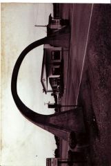
From the album: Arch on Highway 61
Here is a pic of the Arch I referenced in my Highway 61 pleeth...Tsingtao Kip -
Arch on Highway 61 at MO/ARK border
-
Us-61 & Natchez Trace Parkway Road Trip
rudkipon66 replied to DennyG's topic in U.S. Highways & Auto Trails
It takes me awhile to catch up sometimes...sounds like you had a great trip here, Denny... As I have probably told some of you a dozen or so times, the wife and I make the trek through the Delta on Highway 61 on our anniversary every year to the Arkansas Blues and Heritage Festival in Helena, AR: www.bluesandheritage.com We generally are off and on Highway 61 from Sikeston, MO....pass through great road towns like New Madrid and Portageville, under THE ARCH at the Missouri/Arkansas border built in 1924 by the Mississippi County Highway Department, through Blythville, Osceola and Frenchmans Bayou to the intersection with US 63 (where we forever ponder "where does US 63 South REALLY go to?)...have to get on the interstate here, or you miss the Stuckeys at Exit 14, where the exit ramp literally takes you into the parking lot!...Memphis, did I forget to mention Memphis...home of Elvis and the Ancient Greeks?...61 meanders through South Memphis (and is a few blocks away from Beale Street, Elvis' house and...most importantly...the National Rought Iron Museum!)...then cruise into Mississippi... You CAN take a lot of old 61 from Wells MS (the first town you come to) south to Clarksdale...if you look at Google Earth, it marks out the route....there is a little bit missing from Lake Cormorant to the first batch of Casinos, but it is there after that...also if you stop at the tourist info center (on new 61 North of Tunica) you can get a map of Tunica County that has it marked on it...also, at the intersection of US 61 and 49 (where 49 veers off to cross the river at Helena)...if you take 49 towards Helena there is another tourist information center just past the intersection...there you can get a map of Coahoma County that has the route well marked on it... In addition to what Denny said about Clarksdale, there is a great place to eat in downtown Clarksdale called Delta Amusement Blues Bar....it doesn't look much like a bar on the inside (more like a small town cafe') but they have GREAT food and if you get to meet the owners father (who will just sit down with you like he has known you his whole life) its a real treat...also right down the street is a great "all sorts of blues stuff" store called Cat Head. It is run by a guy named Roger Stolle who used to do a blues radio show in St. Louis...its a great place to get books...one book you should get if you want to tour the blusey side of the delta is a book by Steve Cheesborough called "Blues Traveling: The Holy sites of the Delta Blues" It is a great guide...finally, Roger has a newsletter he sends out for free (by email) that will tell you more than you willl ever want to know about the Delta Blues scene...to get it email roger at roger@cathead.biz... Sorry about the roll...we are in the middle of an ice storm which leaves nothin' for a man to do but sit around and think...61 is a Great Drive north and south of Clarksdale...hard to find a road that takes you along a great lake, along a great river, and through a sea of cotton fields enroute to a sea of swampland...see Tim Steils book on Highway 61 for inspiration...who knows, maybe someday there will be a Highway 61 website...maybe an Association...oh well we hope to get to the new Highway 61 Roadhouse tonight (if the ice doesnt stop us) (hwy61roadhouse.admitonevip.com)...it isn't actually ON Route 61 (it is in Webster Groves, a suburb of St. Louis) but its got its heart in the right place... Tsingtao for now...Kip -
Hello all! I am planning a cruise down the Booneslick Rd. From St. Charles to Booneville, MO, which pretty much follows old 40. I was looking at eateries in Booneville and came across a couple and wanted to know if anyone had any thoughts: 1) The Stein House Cafe: Has anyone eaten/drank there? Was it pricey/reasonably priced? 2) The Hallway Club: Is it still around? Please advise...thanks...Tsingtao Kip
-
For those who are interested Union Station opened a "Harvey House Diner", which, according to the article in the Post Dispatch, "pays homage to the Harvey House restaurants that operated in many train stations, in cluding the one in KC". Supposedly looks a lot like the original diner and has some of the same culinary delights. The only disappointment was that "the waitresses were not wearing the crisp black and white uniforms of the "Harvey Girls" who brightened the first restaurants. Tsingtao Kip
-
Quinn, Natalie and I took a great trip back in August to Bardstown, KY–home of Stephen Foster, Jim Beam Bourbon and many fond childhood memories for Quinn (who was celebrating her 24th birthday, give or take a few–not that you could ever tell!). We took off on Saturday morning and trekked the superslab (I-64) to New Albany, IN...here we veered off the superslab in search of the Dixie Highway. Found a little bit of it going through Floyd’s Knobs, IN (where the Dixie Highway is called the Paoli Pike) that took us to New Albany. In Floyd’s Knobs, we found a great bridge and a rather terse gas station attendant who just did not care that I had just found something! Natalie gave us a bit of a scare when she swallowed a peppermint wrong, but she recovered in grand style, and we were off to Louisville. Before the trip, I did some reading up on the Dixie Highway, and I was really suprised at how little there was available (other than on the internet, where you will find a few sites) about the road and was more suprised at how unmarked it is. The only way you know you are on the Dixie Highway is because the streets on the towns through which it passes are marked "Dixie Hwy." or "Dixie Ave".. Maybe it is better marked elsewhere along the Dixie Highway, but not in Kentucky or Southern Indiana. Considering the import the Dixie Highway had on North/South road travel, creating a network of highways between its eastern and western alignments, I would think that the road would have been better identified a la the Lincoln Highway or the National Road. We took the Dixie Highway (US 31W) through Louisville. I am not going to make judgments about taking the Dixie Highway through Louisville, as I always get my dander up when people shun the North St. Louis alignments through North St. Louis. However, I think I need to be educated on what I am looking for through this stretch. It is not dangerous, but unless I am given a reason, I probably won’t go through there again. When we got out of Louisville, the road turned four lane and we stopped at an excellent little greasy spoon called J-Boys (Jerry’s). It has a cool retro interior, sweetened tea without asking for it, and a pretty good burger. It also has a nice Elvis mannequin that kept Natalies attention! From Jerry’s, we cruised down the Dixie Highway south to Elizabethtown (US 31W), through some of the prettiest country I have seen in a long time. You also go right through Ft. Knox and past the gold depository. You cannot take pictures on this stretch; when I thought about it, Quinn reminded me of my experience when I tried taking pictures at Stateville Prison, so I refrained. Elizabethtown is a pretty place. It has a great movie theatre (the State) and several mom and pop motels. This is where the WK and Bluegrass Parkways intersect, and was the place where mom and dad always stayed on their first night heading east to pick up my brother and sister. I looked for the Motel but couldn’t find it. As my last trek with the folks through Elizabethtown was 30 plus years ago, I wasn’t suprised. From Elizabethtown, we headed south on 31W through some beautiful countryside and cool old towns on the way. You are never more than a half mile from I-65 through here, but, with a couple of exceptions, you could be a hundred. We passed through one town (Bonnieville) that had an awesome Motor Court sign (OK Court, I believe it was). Just past Bonnieville, we came across an old bridge that had to have been from Dixie Highway days. We stayed the course down the Dixie Highway through Munfordville and Horse Cave, and on to Cave City, situs of the Wigwam Motel that is NOT on Route 66–the Wigwam #2 Motel! From the outside, this place is cooler than the other side of the pillow! The Teepees are in an oval, facing a big greenspace and play area (Natalie LOVED it!) Behind the teepees, there are a row of beautiful pine trees. The Motel is on 31W, but the back side of the Motel "fronts" the "Old" Dixie Highway (SR 335). The grounds are neat and well kept, and the "lobby" (check in teepee) has a lot of neat little mementos you can pick up of the place. One of the proprietors made plaster casts of the Wigwams, which are pretty neat. The owners were extremely nice, and were the only people I came across that had any clue that the Dixie Highway was more than just another street. The Wigwam 2 is undergoing some renovation. It is getting a fresh coat of paint and new paneling in the rooms. The rooms themselves would be perfect for two people and one bed. If you have three people and two beds (including a 3 year old running rampant) is a bit tight but manageable. The rooms and bathrooms are clean and the shower is downright awesome (gives new meaning to the term "water pressure"). The floors are linoleum (I imagine this is the case because the soil in these parts is largely clay and it creates a big mess wherever you track it.) The only complaint I had (and it is easily rectifiable) is that they have to do something with the air conditioner–it was loud and was secured in the window with duct tape. I presume that it will be remedied as part of the renovation. We were going out to eat that evening, but decided to get carry out and eat there, enjoying a fried chicken dinner at one of the picnic tables on the motel grounds and watching the trains pass nearby and the sun set. Other folks had the same idea, and as dusk neared you saw almost everyone staying at the motel walking around, chatting away, enjoying the place It really felt like what it must have been like to stay at a motor court during the 30's...real neat! We ended the evening with Quinn’s birthday cake, and I got a few shots of the Wigwam Motel sign, with the neon a blazin. The next morning (Sunday), we bid the Wigwam #2 adieu, and, after what was called a breakfast at a place called Jerry’s (great sign, lousy food), we took Natalie to one helluva great tourist trap: Dinosaur World. The place is full of life size models of every dinosaur imaginable (including one called a "Tsintaosaurus"; I have one on top of my computer!)...Dinosaur World has one of those gift shops like Meramec Caverns–anything they could stamp "Dinosaur World" on, they did! Also, Natalie got to "fish" for fossils and came up with a couple of Shark Teeth–she had a blast! After Dinosaur World, we cruised through the tourisma around Mammoth Cave. Along the way, we came across one heck of a tourist court (The Oakes Motel) near the Cave. We then took the Dixie highway back to Munfordville, where we got completely confused by the tourist brochure they offered, but did see one excellent bridge trestle (for the L and N Railroad, which was pretty significant during the Civil War). We took SR 88 from Munfordville to 31E, and trekked North on 31E (aka the Jackson Highway). Enroute to Bardstown, we took in some of the Lincoln tourisma around Hodgenville, including the birthplace of Abraham Lincoln and Lincoln’s boyhood home. Both are GREAT roadside attractions. Lincoln’s birthplace is in a marble "tomb" that would be better suited to house lincoln’s remains than a rickety one room cabin....there are 56 steps up to the "tomb" one for each year in his life. Right next door (literally) is Nancy Lincoln’s Tourist Court, which was built in 1926, with little log cabins for the rooms. Lincoln’s boyhood home is right on 31E–literally a wide spot in the road. The site is kind of a throwback to the heyday of blue highway travel, when roadside attractions were right on the highway, not a mile away, across a huge parking lot, behind an iron gate. In Hodgenville we ate at a little place called Harpers. It is a bona fide mom and pop–the whole family runs the place. They have several flavors of soft serve ice cream (very tasty) and they have some good road food. Harper’s also has a fine sweetened tea, which you can buy by the gallon! From Hodgenville, it was off to Bardstown The trek down 31E was as scenic as 31W, sometimes more so. One other thing you saw along 31E was tobacco fields. The huge tobacco leaves were turning yellow, getting close to harvest time! We were greeted to Bardstown by a distillery and a huge Catholic Cathedral. A short trek to the left landed us at the General Nelson Best Western. It was a very excellent, very comfortable place, and we had a room with a door that literally opened to the swimming pool! Across the street was a 1950's mom and pop motel, "My Old Kentucky Home Motel", complete with an awesome sign, especially at night with the neon a blazin. That evening, Quinn had tickets for "Stephen Foster, the Musical". Sensing BBQ down the street, I had to have a little dinner before we went. We ate at Bryan’s Hog Wild BBQ (on US 62, just West of the Best Western). It took awhile to get the food and frayed a nerve or two, but I don’t think I have ever had a better BBQ pork sandwich in my life. Highly recommended! From there we went to the Musical, which was a lot of fun; especially watching Natalie Kay "dance to the music". Went back to the Motel and spent the late evening hanging out watching a local car sales show and the hilarious "Kain-Tucky" hosts. On Monday, we trekked up Federal Hill and saw "My Old Kentucky Home", which was absolutely beautiful. The State of Kentucky has gone to great lengths to keep the original furnishings, and have done a wonderful job with what has had to be reproduced. Afterward, we cruised downtown to Talbott’s Tavern, a 1790's roadhouse and coach stop. This place had food to die for: We had Country Ham and REAL cornbread (cornBREAD, not cornCAKE!). To this day, I am still not hungry. We then took a horse drawn carriage tour of the town and saw many of the historic buildings in Bardstown, including a Sears House (with an "S" on the chimney). Afterward, we went to Spaulding’s, an old department store, and then stopped at Hurst’s Pharmacy, which has a great soda fountain that serves even better ice cream. We then took a tour of an old prep school that contains the Getz Whiskey Museum, where you will find, among other things, one of Carrie Nation’s hatchets. That evening, we hung in the room with some great pizza, and I took advantage of the moment to take some shots of the neon display on the "My Old Kentucky Home Motel sign. On Tuesday, we bid adieu to Bardstown with a fine breakfast at the Steven Foster Restaurant. We cruised up 31E to Louisville, crossed into Indiana, and took a chunk of the Ohio River Scenic Byway. Passed a "new" Mail Pouch Tobacco sign on a barn outside Corydon, and then made a stop in Corydon, the site of the first Indiana Capital. Also took advantage of another great pharmacy soda fountain at Butts (yes, Butts) Pharmacy there. The Scenic Byway west of Corydon is beautiful, and would be a great trek in the fall. We stopped at a wide spot in the road in Leavenworth, IN and took a look around Stephenson’s General Store, got a great view of the Ohio River, and finally took a stint on Indiana Route 66 before we got back on the superslab and headed back to St. Louis. It was a great trip, a great weekend, and I would recommend any part of it to anyone! Tsingtao Kip