


mobilene
-
Posts
1,247 -
Joined
-
Last visited
-
Days Won
1
Content Type
Profiles
Forums
Gallery
Blogs
Calendar
Posts posted by mobilene
-
-
Love the Tucker photos.
I suffer from lack of optical image stabilization. I lost a couple photos on my most recent trip to camera shake.
-
Does a wino want a case of Thunderbird?
YES! I would LOVE to see the info on the 1920's "new" sign standards!
-
Those cutouts sure look shiny and new. One way to tell is to drive through there at night -- if they reflect like a beacon in the night, they're pretty new. But it's not Indiana's style to go against standards.
I think the cutout shields look great. Only thing that might enhance them is to add the thin borderline near the edges. The borderline-less style is usually affixed to Big Green Signs on the Interstate.
Speaking of green signs, sign colors have meaning, and green means "guide," just as yellow means "warning" and orange means "work zone." Whether you know it or not, your subconscious knows what kind of info is on a sign just because of its color before your conscious can even read the thing. I agree that these white on green signs are not the most legible, but they could have done things to help that, notably increasing the font size and switching to mixed case.
jim
-
On my way home from the US 31 trip I did a little exploring through corn country. I was on US 6 in LaPorte County when I came upon these directional signs at the intersection with US 35. I have never seen cutout shields in Indiana! What's especially interesting is that the directional signs (North, South, etc.) use the modern big-cap, small-cap style. I wonder how old these shields are.
Westbound on 6:

Eastbound on 6:

I headed south on 35 from here, and then followed a bunch of state highways until I joined the Dixie Highway in Logansport. I followed that the rest of the way home.
jim
-
Whatever you see, it will be great if you share photos! jim
-
Wait... pardon the question from the Midwesterner, but how did those bridges end up under Lake Shasta in the first place? jim
-
How neat to have your grandfather's memoir. Not many people have anything like that.
And that cut is something else. I can't imagine what it must have been like trying to get from south to north, or vice versa, even with it.
-
I just did an eBay search on "auto trails" and got 20+ hits for old auto trails maps, with no wading through junk entries.
I tried "Rand McNally map" and got 2 pages of results, meaning some wading, but found several interesting items.
-
Alex, that must have been some trip through Peru then, given what awaited at the destination. 70 to Effingham is a crashing bore of a snooze, set against a sleep-inducing backdrop, so I'm not surprised your alternate route was better.
Denny, it looked to us like that was the old road bed. It was weird, and I wish I got a pic of it now, but the road used to curve to meet the old bridge. The road went straight over the new bridge. Maybe there was an earlier bridge on the new bridge's site.
The camera still works; the Indy photo above was taken with it broken like that and I didn't even notice yet. I just like my things to stay nice. It's like the transport on one side of the lens got disconnected in the impact. I guess the lesson learned is to WATCH where I'm GOING when I have the camera in my hand.
jim
-
I sure hope they get Scenic Byway status. I want to come out there and drive that road one day.
-
I finally made my US 31 trip with my old friend and we had a ball. He's never done any roadsleuthing before, but when I handed him my 1924 ABB and ordered him to navigate, a change came over him and he became just as obsessively curious about where the road used to go as I am!
If you ever do this trip, I recommend Plymouth, Rochester, and Peru as nice towns. I do not recommend Argos or Mexico; they're decaying little dots on the map. I found Kokomo to be remarkably unremarkable.
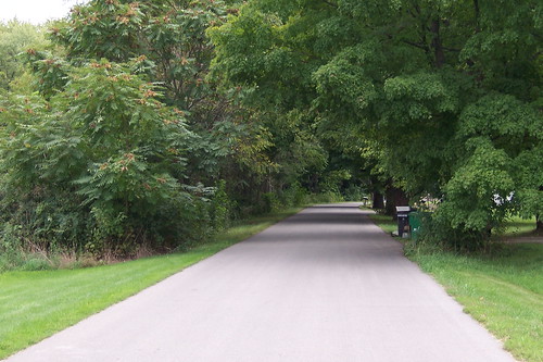
Before sunrise, new lamps (reproductions of originals) light the Leeper Park bridge over the St. Joseph River on South Bend's old northside. My mom grew up near here, and my brother had an apartment near here, and my old friend currently lives just around the corner from here. This is part of US 31's old route through South Bend.

The Morris Performing Arts Center on US 31's first alignment through South Bend.

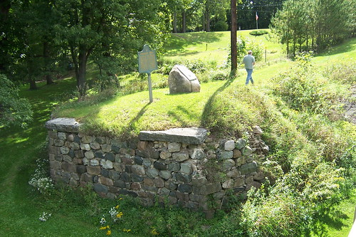
There used to be a notorious one-lane bridge on 31 north of Rochester, IN. My friend (who's in the pic below) remembers it from trips to visit family when he was a kid, but by the time I first traveled 31, the road had been rerouted around Rochester. This abutment may have been from the old bridge. A modern 2-lane bridge was built in 1982, and I stood on it to get this shot. The historical marker commemorates the Michigan Road, and the plaque on the rock remembers the Potawatomi Indians when 850 of them were marched at gunpoint from Indiana to Kansas in 1838 through here -- it appears they followed what would become the Dixie Highway to Logansport. 40 Potawatomi died. I'm (a very small) part Potawatomi.
My friend wanted to follow the 1924 ABB route through Rochester. The book said this was State Road 1. (Indiana's state roads were renumbered with the coming of the federal numbered highways.)
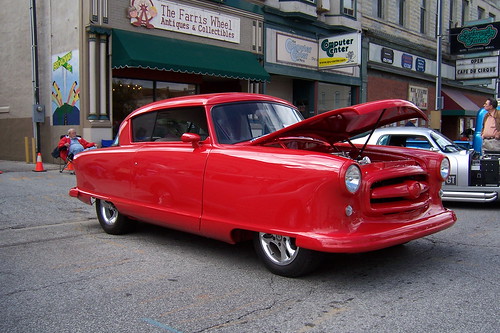
In Peru, I was thrilled to come upon a classic car show. They closed a downtown block of old US 31 for it. I blogged about a 1966 Plymouth at the show (http://jimgrey.wordpress.com). Here's a pic of a 1955 Nash that has been very heavily modified.
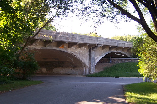
In Indianapolis, we tried to figure out why the map said Meridian St. (old 31) went over the White River and another road right next to it also called Meridian St. didn't. We think that this was probably a case of a bridge replacement that moved the road a bit. This photo is from the older bit of Meridian St. of the current bridge.
I'm not sure when I'll have time to write the trip report, so I thought I'd share some highlights now.
The only bummer on the trip was in Kokomo. I was stepping backwards to get a building in my camera's frame when I stumbled over something. My camera went flying and landed in the grass. Now the lens doesn't extend properly when I turn it on. It comes out at a slight angle, and I have to tap it into position.

jim
-
Buy the following when you can
1916 - 1924 Automobile Blue Books of your area (Include one T or Transcontinental)
1920-24 Rand McNally Auto Trails maps of your area
1920-24 TIB National Edition (North or South)
1920-26 Hobbs Guides of the roads you are interested in (e.g. National Old Trails, National Road, Dixie Highway)
Maybe a 1925 -27 road atlas, and a 1939-49 road atlas
Now that is valuable advice! I've copied this list and will start looking for these resources. Having what I already have is vastly enriching my road trips, if nothing else because I'm so much more sure of where the roads used to go. And it's fascinating how they help me recognize old routes now that I never noticed before.
Driving south on US 31 from Westfield, at about 146th St. US 31 curves wide right and there's an exit to IN 431 that curves left. I work 2 miles south of there, and have driven through there hundreds of times since the early 1980s. They've even redesigned and rebuilt this "split" at least once during those years. But what I never noticed until recently was lonely old two-lane Rangeline Road, and how it actually continues straight south from the split. It gets lost in the shuffle. My 1924 ABB, along with one of the maps you posted for me some time ago, show the route to Indy coming south on what is now US 31 but entering Indy via the former towns (now neighborhoods) that are on ... Rangeline Road. And now, when I drive south on 31 through this split, I can't help but see Rangeline dead in front of me. I wonder what the area looked like when only Rangeline existed. I remember when this split was out in the middle of nowhere; today, it's retail strip mall city and a mess to drive through.
jim
When I encountered that last night while plotting with SA2008, I just assumed there was no bridge. I'm not very quick with the imagery stuff.I'm curious about what the Windows Live Local imagery is showing me. I've seen the online maps show roads that don't exist, but so far in my usage when they say there's no road, they haven't been lying.
jim
-
As the PP-OO enters Danville from the west, it went over a bridge as shown here:
http://www88.pair.com/davepaul/americanroad/PPOO47.jpg
The online map sites show that the road ends before the creek (or whatever) and picks up on the other side. Here's Windows Live Local.
http://local.live.com/default.aspx?v=2&..._&encType=1
But the aerial view shows a bridge going over the creek. I wonder if it's closed to traffic or something.
http://local.live.com/default.aspx?v=2&..._&encType=1
jim
-
Good grief, Keep, I must be getting hooked, because I want all of these resources you've posted.
It seems like the map and guide people had a hard time keeping up with the PP-OO.
But it also looks like the final PP-OO route pretty much follows the 1924 ABB route.
jim
-
Bring on the 1924 Rand McNally!!! jim
-
All those years I lived just south in Terre Haute and I never went to the hill climb. I have got to do that one year soon.
-
My ABB doesn't say anything about the Dixie Bee Line through there.
I was under the impression the Dixie Bee Highway followed US 41. Now this is anecdotal information and not based on maps or guides. So I thought it entirely plausible that this highway followed this road as it headed off toward Danville.
It does look like that this road may have been part of the DH, according to http://www.us-highways.com/dixiehwyw.htm.
jim
-
It looks to me like the PP-OO was in the process of being rerouted to its final routing in 1924-1925 then. My 1924 ABB couldn't be clearer that the PP-OO went through Indy, Danville, Bainbridge, and Rockville, more or less along what is now US 36. But given that it was probably published in like late 1923, who knows. People trying to follow the PP-OO using maps and guides had to be feeling very confused in those days. Which direction does the road take today?
Interesting that, per your map, the PP-OO goes through Marshall, IN. I've been through there out of curiosity. There's a big ... not arch, what the heck are they called anyway? Pillars with a crossbar over the road announcing the town. But there's so little town there you wonder why they bothered announcing it. Maybe they were hopeful it would grow to be more.
jim
-
I'm about to hang it up for the night, but real fast -- the westbound route is the exact opposite of the eastbound. Cville to Waynetown to Hillsboro to Veedersburg (via Dixie Bee Road) to Covington.
Bear in mind that my 1924 ABB isn't calling this route the PP-OO -- in 1924, the PP-OO still took the route through Rockville, Montezuma, and Chrisman. I'm just making an educated conclusion.
-
Now that I'm looking at it again, I wonder what sources I was looking at last time that made me so sure of myself. Oh, and that IL 6 is a case of me getting hung up on Windows Live Local's labels. That's some county road.
I believe you are right, Denny, about the route, down to following some smaller roads between Decatur and Champaign. These scans from my 1924 ABB lay out the route and I can track it on Google Maps pretty well. There's some weirdness just west of Decatur and around White Heath where I-72 may have obliterated some of the old route. It looks like a few blocks of a street aren't there anymore in Urbana. I can't at all figure out how the ABB is telling me to get from Oakwood to Danville. It also puts you on the Dixie Bee Highway from Covington to Veedersburg.
The ABB doesn't call this out as the PP-OO, but it looks good to me.


Good grief, this stuff is fascinating. I've spent 90 minutes figuring this out, and I didn't even realize the time passed.
-
Not that I can tell. In Indiana, at least, 32 goes directly through all the towns on the PP-OO's final route. There is little evidence of roads that diverge and converge (as on the earlier US 36-based PP-OO alignment), and I don't detect any other road that hits all those towns.
I wonder if my 1924 ABB will shed some light (he says, puffing out his chest over his new acquisition). I'll try to find time to look this evening.
jim
-
There's a very good possiblity I can shadow you on the way home Sunday. A question I have for you or mobilene is if either of you have have it mapped yet? I've been looking at it from my 1925 auto trails map, but haven't actually transferred any of the info to a usable map with current county/state/US routes on it.
If you mean the final alignment of the PP-OO in IL and IN, I think it's a safe bet that it's simply IL 6/IN 32. By the time of the PP-OO's last routing, I'm betting these two roads were pretty well in place. I traced the IN portion via Google Maps and saw very little in the way of former alignments.
Is that what you're asking for?
-
Wow, $400 for a week is awesome. Now, that's planning. I just wish I liked camping better. I can do it, if nothing else because of the cost difference, however. jim
-
Yeah, well, the weekend of the 29th is when I was going to be moving into my new house. That has been placed on hold, probably by two weeks, but then the problem becomes that any dollar I didn't put into buying the house needs to go into buying things for the house. I'll just say that this is my first post-divorce permanent residence and leave deriving the rest of the equation as an exercise for the reader. With any luck there'll be another 66fest next year and I'll be able to go.
So the Springfield to Crawfordsville co-cruise is probably out. But I might welcome a day off on Monday, if I can get it, and we could cruise across the PP-OO from C-ville east. Lemme know if that'd work for you, or whether you'll just be focusing on getting the heck home that day.
Looks like IL 6/IN 32/OH 571 could be the PP-OO -- it goes from Danville, IL, through Crawfordsville, Lebanon, Anderson, and Muncie, all towns on the PP-OO in 1927.
jim
Cutout-style Shields
in U.S. 6
Posted
Thanks for the link, Pat. I'd never seen the Oklahoma site before. That Alt. 69 shield looks cut from the same cloth as the 6/35 shields I saw.
Tracy, I looked at the Indiana page on the link you shared. Does it say something about me that I can tell you exactly where three or four of those photos were taken?
jim