Dave Darby
-
Posts
17 -
Joined
-
Last visited
Dave Darby's Achievements
Day Tripper (1/6)
0
Reputation
-
Through my research, I was able pin down the exact date and time(!) the River to River Road was conceived. At 9:00 AM Saturday, June 25th, 1910, 10,000 farmers and volunteers started work, and one hour later, completed the construction of Iowa's River to River Road - grandfather of Highway 6 in Iowa.
-
Hi Dave, according to Iowahighways.org, that section of US 32 was paved in 1926. The practice of putting the lip curbs in started about a year or two after that, a practice that lasted about 10 years. This stretch was straightened and bypassed sometime between 1957 and 1963, and I just don't see them replacing that pavement in between. It's entirely possible, but who knows...
-
Back when I was a kid, we had a camping spot in Moscow - no, not in Russia, but Iowa. Whenever we'd ride our trail bikes in the woods near the Cedar River, we'd see these old bridge piers. Back then, I had no idea how old they were, or what historical signifcance they had. It wasn't until 2007, when I met Historian Lyell Henry, and he loaned me a copy of Huebinger's Map & Guide to the River to River Road that the light bulb clicked on... There it was, this odd "S" curve, west of Moscow, where the river bent. And "the bridge." Moscow has a piece of arguably some of Iowa's oldest highway pavement, dating back to between 1912 and 1915. This strip obviously dates back to the River to River Road days, through IA Primary 7, Whiteway 7, Detroit Lincoln Denver Highway, and for about 3 - 4 years, US 32... At the end of this stretch of pavement, to the right, is this bridge pier... Which goes with these bridge piers... Now, through my research, I learned that "Call of the Wild" author Jack London's father lived in Moscow around that time, and was involved in building a bridge near Moscow. Possibly even THIS bridge... Now, finding actual photos of this bridge turned out to be quite the challenge. In fact, it took me about 3 years, but when it rained, it poured, as I managed to find an old post card on Ebay, and someone from the area sent me a scanned copy of another... They sure don't build 'em like this anymore! By 1926, the Federal government was in the highway business, and the route that the Moscow bridge was on was both too narrow, and to convoluted. So in 1930, when US 32 was paved, a new bridge was constructed to the south, and the the Moscow bridge was decommissioned. That straight route at the bottom is US 6 in the late 30's... By 1942, we were at war with Germany and Japan, and steel was at a premium. On March 2nd of that year, the Muscatine Journal reported that "The board of supervisors has condemned and closed the bridge." The farmers got up a petition to repair and reopen the bridge, but by the time this 1944 flood photo was taken, the Moscow bridge was gone... People driving over the Cedar River on Route 6 can still look north and see the piers, as they drive by. So one of Iowa's oldest highway bridges is gone - but it isn't forgotten.
-
Unbeknownst to most folks driving the busy 4 lane, interstate-like US 61 past Maquoketa, Iowa, is this quaint and quiet section of old US 61 that was bypassed in 1967. Now known as 182nd Ave, the pavement leading up to this bridge was laid in 1929. (Thanks to the landowner, Bruce for graciously allowing my wife and I to explore this section, which is gated off. One can imagine what it was like when two semi trucks passed each other on this narrow bridge. Bruce told me that that back in the heyday, you could see the sparks when the trucks would clash mirrors at night.... Here is the view from the north. The weeds have all but taken over the pavement... Looking north again at the Blues Highway, stuff of Bob Dylan songs... And an over-all of the bridge... At the north end of this stretch, looking south... Father north we find another abandoned section of US 61, comeplete with the ubiquitous haybales. New 61 has cut the old into many sections, criss-crossing as we head north towards Dubuque... 104th Ave, south of Zwingle, Another abandoned stretch picks up again on the other side of current US 61. You can pile on all the asphalt you want, but there is no disguising an old highway alignment.... Until next time...
-
As promised, here is one of the coolest abandoned highway sections I have ever seen. Abandoned in the late 50's, this section is cut off from the main road, and is over grown with trees. Another neat feature is the notorious Iowa curbs. This was an Iowa experiment gone awry that lasted from around 1927 to the late 30's. Cars would ride up on the curbs, the driver would over correct, and head into oncoming traffic. A three year project begun in 1977 removed all the curbs from any remaining state of federally controlled highway still using them. Here is the east end, where it was cut off, by removal of the bridge... In this later photo, you can see those curbs on the left hand side... Here is an aerial view from the 1930's.... Abandoned US 30 1930's In the 1950's layer, you can see the transition starting... Abandoned US 30 1957 1963... Abandoned US 30, 1963 And in 2009. You could drive right past, and never know it was there... Abandoned US 30 2009
-
Hi Jim, luckily for us in Iowa, we have the Iowa Geographic Map Server. Iowa Geographic Map Server (big window)1930's layer Picture Google maps with 1930's 1950's and so on map layers.... 1930's And here in the 1963 layer, you can see the scars... (yes, a bit more zoomed in...) BTW, these images are from my rather poorly organized Rt 6 album on Fotki. US Route 6 albums I created the key and legends with Adobe illustrator for my book on Route 6 through Iowa I am working on.
-
US 6 (originally US 32) in Iowa once followed a large "S" path between Tiffin, IA and Homestead, IA. Sometime between 1957 and 1963, they cut out the curves completely, in favor of one one boring straight line. Two sections remain as traveled roads, "Lower Old HWY 6 Road, and "Lower Old HWY6 Road". Between them is this gem, now used as an easement. It is approximently a mile long, but the east portion is gated off, while a garage is built over the access to the west portion. Still, there is this dandy few hundred feet of unmolested pavement dating back to 1926. Love those 9 ft lanes.... Isn't it striking how cozy the highways used to be with the surrounding land? Nowadays, there are deep ditchs and wide shoulders on either side of the road. Coming up, more Old US 6/US 32, and a way cool abandoned US 30 alignment.
-
Sure did, it's a King Iron Bridge, Cleveland, Ohio, built in 1882.
-
Thank you, Jim, I also really enjoy your website, with the tour of the old National Road. I've seen some of those Right Of Way markers not to far from my neck of the woods in Illinois. Speaking of old bridges, and abandoned alignments, here is 288th trail, east of Adel, the only unpaved section of US 6 (bypassed when the paving commenced) and the bridge this path crossed the Raccoon River on. It serviced the River to River Road, IA Primary Road 7 (early state highway), Detroit Lincoln Denver, Whiteway 7, US32, and finally, briefly, US6. And from the east end...
-
Hi Dave, apparently there is a limit to how many photos you can put in a post here, so I had to leave a lot out. I also didn't put much in that was also on Route 6. This art deco Coca Cola bottling plant in Atlantic was pretty neat, too... Perhaps I should do a part 2 post! BTW, I just recently discovered your historic road maps page. I plan on making great use of that! I have been doing some collecting of old maps myself. We should talk.....
-
2010 marks the 100th anniversary of Iowa's oldest auto trail. Signed in one day (date unknown) in 1910, the River to River Road traversed Iowa from the Mississippi River in Davenport to the Missouri River in Council Bluffs. Later, this route later became part of the Detroit Lincoln Denver highway. In honor of this anniversary, my wife and I made two trips utilizing as much of the original alignment as possible, and took loads of photos. During this trip, we encountered all manner of roads, from paved to dirt. Without further ado, lets look at the pics! A rarity for its time, as most markings were painted band on poles, this sign dates back to 1912... Huebinger produced a detailed map and guide in 1910... You can see the whole thing here... Huebinger's Map and Guide for River to River Road This is the world's oldest continously operating Ice Cream Soda Fountain, in Wilton Iowa. The Wilton Candy Kitchen. You want the real thing? This is literally kickin' it old school. 91 year old George Nopoulos still makes his own ice cream, and everything is made with natural ingredients. Do NOT miss it. This bridge south of Kellogg, Iowa once carried River to River Road (and US 32) travelers over the North Skunk River... A meeting of the Grand Army of the Republic, in Redfield, Ia... Not much remains of some of the towns along the River to River Road. When US 32 (immediate predecessor of US 6) came through Iowa, it turned south at Redfield, Iowa, and headed west on the competing White Pole Road auto trail... So most of what follows is from the abandoned portion of the route. Dale City was first of the towns that were bypassed... Another bypassed town is Monteith... Next up is Guthrie Center, Iowa, which features some of my favorite architecture.... West of Guthrie Center, we found an abandoned IA 44 alignment and this equally abandoned general store... Apparently, they plan on restoring this old Hotel in Marne, Iowa, just NW of Atlantic... This great old house is on IA 83, another segment of the River to River Road... I'm not sure what this little building in Walnut was, but I like it... This is the Phoenix Theater in Neola. It's being restored to it's original 1913 appearance... This is the golden spike, in Council Bluffs. According to Wikipedia "In 1939, following the premiere of the Cecil B. De Mille motion picture Union Pacific in Omaha and Council Bluffs a gold-colored concrete spike 56 feet (17 m) in height was unveiled on 9th Avenue in Council Bluffs on the approximate location of milepost 0.0 of the First Transcontinental Railroad." There is so much more to see, but not enough room here, so until next time....
-
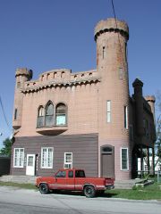
Well now, what with me being part of trhe Route 6 Tourist Association, it would behoove me to post a little something in the vein of what you are talkin bout, Russ.... I give you Castle Hall, in Walcott, Iowa, and a mural by Carl Homstad in Newton, Iowa. First up, the castle... One of the more interesting sights in Walcott is "Castle Hall" Built in 1905, the designer intended to replicate the Balmoral Castle, an old Norman stronghold in Scotland. When first built, the metal panels that cover the framework were gray. Beneath the tower is a basement dungeon that was once the subject of much speculation. Originally the home and business of Doctor Henry Schumacher, his residence was on the second floor, while the pharmacy was on the main floor. Quite the eccentric, Dr. Schumacher kept a pair of plaster of Paris skeletons in the basement dungeon, painted with phosphorescent paint to awe his visitors. After the doctor passed away in 1934, the first floor was used as a "beer parlor." Next up is the amazing Carl Homstad mural "Welcome to Newton" Carl painted this previously light blue building wall to look like a group of buildings. Most of the doors and windows were painted on as well. To see more, go to http://www.carlart.com
-
Iowa's Lincoln Highway
Dave Darby replied to brownwho63's topic in Lincoln Highway / U.S. 30 / U.S. 50
I may have to talk with those LHA guys about that whole "River to River" thing. (Wink). The original route of US Route 6 through Iowa was mostly based on the "River to River Road", quite possibly Iowa's oldest auto trail. Altho not registered until a few years after the Lincoln Highway and the "Great White Way" (White Pole Road), it was first promoted in 1910, and existed back in the 1800's (apparently under the "River to River Road" name) as a stage road. http://public.fotki.com/DWDarby/two_lane_highways/ -
Iowa's Lincoln Highway
Dave Darby replied to brownwho63's topic in Lincoln Highway / U.S. 30 / U.S. 50
I took a trip most of the way last weekend. The Iowa Geograhic Map Server was a very helpful resource for this. (Think Google Earth 1930's... http://ortho.gis.iastate.edu/client.cgi?zo...amp;pheight=450 Cedar County seems to be absent from the 1930's layer, but the 1960's layer will help you find a neat old alignment West of Lowden that you will have to hike on foot to get to.... Take Highway 6 on way back! -
Photos from the past and present
-