


cbustapeck
-
Posts
32 -
Joined
-
Last visited
Content Type
Profiles
Forums
Gallery
Blogs
Calendar
Posts posted by cbustapeck
-
-
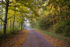
A while ago, I posted about what I thought might be a 1920s metal speed warning sign, on the National Road, in western Maryland. I took advantage of the unseasonably warm weather on Monday to go shoot some photos.
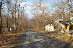
This view, looking north, is the old National Road alignment that the sign is on, on the west side of Sideling Hill. In the version of this photo on Flickr, I've noted the location of the sign - it's on the right side of the road, but a bit before the road curves. I'm reasonably sure that the driveway that goes off to the right is an even older alignment, but as it was private property and the owner could not be located, I've been unable to research that further. This even older alignment probably curved off to the left a bit, as suggested by the flat patch of grass on the left side of the photo.
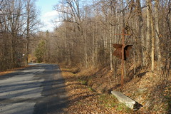
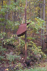
This is the sign itself, again looking north. The side that is visible to us would have been seen by southbound (eastbound) travelers. The other side of the sign has been more exposed to the elements, and no distinguishable markings remain on it.

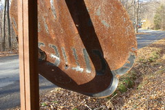
The sign has a black border. At the top is a small ">" in a circle - perhaps a directional arrow. To the best of my ability to tell (and based on a bit of guessing), it reads "Cities Speed Ahead". Is this, then, a direction to slow down to city speeds?
My interpretation, of course, may be wrong. I know this much of the text with certainty:
(>)
CITIES
S
A D
I'd love to hear any other possible guesses / thoughts.
-
Chris, thanks for the tip about the IU library! And you even gave me the right call number. Now I just have to make time to go. jim
Jim,
Let me know how it goes. If you need additional research help, let me know - I'll see what I can dig up.
Christopher
-
Chris,
It's astonishing that the sign still stands, mangled as it is!
How are you doing your research in those Maryland State Roads Commission reports? Hardcopy of Internet? If hardcopy, how do you get access to them?
I'd love to look back through historical records in Indiana, but don't have the first clue how to start.
jim
Jim,
I came across them in the Maryland Department of the public library where I work, in Baltimore. I was so surprised by the wealth of information in them that I can't believe that I didn't look at them sooner. They're especially good for depicting old alignments, as the Commission was proud to show off the great work that they'd done with making the roads safter by straightening them out.
Annual report of the State Highway Commission of the State of Indiana
Indiana University has the closest thing to a complete run that I've been able to find (call number HE356.I6 I633), but, of course, I haven't actually called anyone up to talk to them to confirm this.
Once you get through those, I'm guessing that there'll probably be a whole bunch of boring and relatively useless stuff in the same area of the shelf about the construction of roads in the state, environmental impact studies, and perhaps even proposals for road plans through a given area. A librarian there ought to be able to help you more than I can.
-----------
Alas, I'm not going to be able to take a better shot of the sign anytime soon. I'm driving up to Ohio on Friday morning to view the house of our (my wife and my) dreams and spend Christmas with my side of the family.
But hopefully, I'll be able to get a scan of the image of a similar sign up before too long.
-
I photographed this sign on an older National Road alignment, on the west side of Sideling Hill, in Maryland a while ago, and I've been wondering what it was ever since. I assumed that it was probably an advertisement for some sort of service station, but it was so rusted as to be unidentifiable.
Recently, I've been doing some research in the old Maryland State Roads Commission reports. I came across some warning signs, and I came to realize that that's what this is - a speed warning sign, cautioning motorists about an upcoming curve. The sign, to the best of my ability to tell, is from the 1920s.
-
From Glen Harper's response:
The office referred to is:
Ohio Historic Preservation Office, Ohio Historical Society
567 E. Hudson St.
Columbus, OH 43211-1030
614-298-2000
That's great! Is there anyone in the Columbus area that we can con into scanning / photocopying the maps? I can put them up on my Flickr account if need be, or, if they have a disk with them already on them, even if they're PDFs, I can work on converting them...
-
Christopher probably knows this but not everyone. This is the oldest standing bridge in Ohio and was designated the Official Bridge of the state's bicentennial. (Did your state's bicentennial have an official bridge? Did your state have a bicentennial?) It was almost taken down in the 1990s but was saved, restored, and even has its own website. I'm betting there are some folks in Belmont County who know something about that marker.
Hey, I don't know everything. Really. I just have good reference sources.
And it was my state's bicentennial bridge, at least at the time of the bicentennial - I'm only recently a Baltimorean. I didn't realize that it was the bicentennial bridge - I'm a former Clevelander - you know, those people who are ignorant of everything south of the Ohio Turnpike.
This goes into my long list of things to do further research on.
-
Tomorrow (Friday) I'm driving from Baltimore to Raleigh, NC, for a wedding. While I think it would be fun to drive the whole way on Route 1, my better half would probably feel otherwise. I'll probably stick to I-95 for the drive from Baltimore to Washington, DC, but after that, I'm not sure.
Are there any sections that you might especially recommend?
Thank you
- Christopher
-
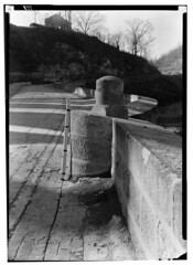
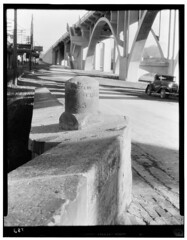
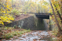
I was browsing through the Historic American Buildings Survey / Historic American Engineering Record at the Library of Congress, when I came across an interesting photograph of the S-Bridge on the National Road in Blaine, Ohio. It seems that there used to be a milestone on the bridge, but that in the intervening years, it has disappeared.
First look at these two HABS photographs, from the 1930s, the first one looking west, the second looking east. Then look at my photograph, the closest that I could find to the angle of the first one. How does a milestone like this disappear? It's not like the milestones by the roadside which can be dug up... or is there a story behind this that makes more sense? Either way, it's interesting.
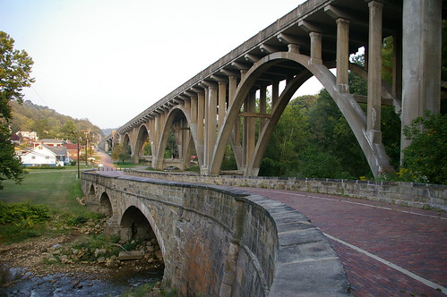
Oh, and because I know you want it, a better photograph of these two great bridges: (or see more from the same set)
-
I just posted a query to OHS asking about the availability of the maps. I'm a member and included that information. I'll share any response here.
Thank you. I sent them an email last night about the maps as well. Perhaps the group effort will help - surely your effort as a member and Ohio taxpayer will cary a bit more weight.
If I haven't mentioned it elsewhere already, I should add that the Ohio Historical Society has published a wonderful guide to driving the National Road in Ohio, A Traveler’s Guide to the Historic National Road in Ohio: The Road That Helped Build America. It's available free for the asking.
-
I clearly spend too much time staring at the computer screen. I was checking out the Ohio Historical Society's material on the Road when I came across this directory. The PDFs with the three letter filenames are sections of maps of counties - unfortunately there's only one map present for each county, when there should be about five. These maps detail every single historic feature on the road, including every item listed in the Intrinsic Quality Inventory (PDF).
The question now is what do I have to do to get the rest of the maps?
This is the website that some of the files are linked to from.
-
Don't know about anybody else, but Maryland links 1 thru 100, sent me to Google Maps in Coffeeville, Kansas. The rest seem to work as advertized.
Hudsonly,
Alex Burr
Memphis, TN
Erm. Yes, that seems to be happening for me, as well. I'm hoping it's a temporary bug.
That said, if you click on any of the milestones listed over on the left, it'll take you to the right spot on the map. Alternately, you can drag the map over to the correct location... but that seems rather time consuming.
I'll check on it tomorrow - hopefully it will be straightened out by then.
-
Mobilene, where are you headed before the snow flies? Our Fall was filled with rain and clouds so I need some sunlit leaves along an old alignment. Get with it!! Bring home the bacon.
Not to take away from Mobilene and his photographs, but since you asked for it, and because I can't seem to resist a request for photographs, here are a few sunlit leaves on an old alignment (and one of my personal favorite photographs), on the Peacock Road, an old National Road alignment in eastern Ohio.
 I like Christopher’s way of handling photos. I have had a niggling feeling that the big photos I have tended to use in my posts were less than optimum in the eyes of the chief moderators...not that you ever complained. But you did “guide” me to the gallery and to flickr on occasion. With Christopher’s approach it appears I can use a flickr account to store different size photos, show what I called super-thumbnails in the post, and easily link to a larger image...without exhausting my forum storage quota. (You recall that discussion!). I will try that.
I only did what I did because I didn't want to have *another* group of admins annoyed at me for posting too many photographs too big. Personally, I'd perfer something around 250 pixels wide, but there isn't any easy way to do that with Flickr...
Finally, I am reminded as I enjoy this forum that it exists because American Road Magazine made it so. I am also reminded that Christmas is approaching...and I am getting my shopping done early this year..by sending friends and family American Road subscriptions.Keep the Show on the Road!
My father (who first told me about the magazine, by the way) informs me that I should be getting a subscription soon. Yay for the early gift-giving!
-
That way, the local version on your computer also had the location info.
Ack! Don't remind me about how much data I have on Flickr that would be essentially lost if it were to go down. I need a Flickr Downloadr to go with the Flickr Uploadr. =)
-
Ahhh! I think I'm starting to understand. Unlike what Jennifer and (sometimes) I do, the coordinates are not made part of the photo's EXIF data but are recorded by Flickr by virtue of manually being placed on a map.
That is correct.
BTW, I believe that the picture you pointed me to as "next one in set" is at the Peters Creek S-Bridge. That's the bridge that was totally rebuilt last year and had grass growing between the bricks this year.Totally rebuilt? Wow. I don't suppose you have any "before" photographs?
-
Aaigh! This is causing me to lose all desire to test software (my line of work) today, and get in my car and drive to Maryland!
I'm sorry. Guess I'll just have to go back to posting lots of boring photos. I'm sure I can dig up a few...
Just wondering, have you seen the Corridor Management Plans for the National Road in Indiana and Illinois? I'm assuming that the "intrinsic quality inventory" section would be just as interesting and useful as the same section in the Ohio Corridor Management Plan.
-
Still no Joy. This picture:
http://www.flickr.com/photos/cbustapeck/14...57602256032563/
has this info:

The two Indiana NR markers are near Centerville.
I wouldn't know a paradox if they both hit me in the face.
Erm. I'm not so familar with the geography and location in Ohio, thus, with a number of photographs, like the one you mention, I don't have any geographic data for. However, if you look at the next one in the set, you will see its location on a map.
Also, if you (or anyone) can precisely location the pictures that don't have location data, I'd love to hear about it.
-
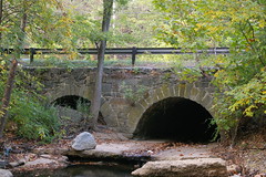
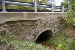
I don't think I've talked about this here, yet...
I've created a map, using Google Maps, of the historic stone bridges on the National Road, in Maryland, complete with photographs, and for some bridges, links to my sets of photographs of the bridge in question. (I haven't had time to link to all the sets, but often I have a set of photographs dedicated to each bridge.)
Most interesting, I think, are the smaller stone bridges that are hidden in plain view, like this stone culvert, just east of Ellicott City. I only found it due to the high quality aerial photographs available from local.live.com. The dropoff is relatively sharp (five or so feet, I think), so the easiest way to get to the point below is to park in the gas station parking lot and walk through the culvert (the water level was low when I was there...) from the other side of the road.
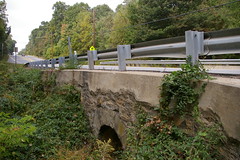
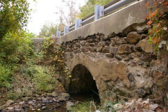
There are several small bridges in Howard County, for most which only one side remains stone - the other side has been lost with the widening of the road. Here are a few:
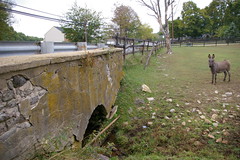
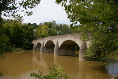
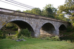
Washington County, Maryland, has more impressive bridges - I plan to document them well, with the intent of pubishing a book - there are 30-35 stone bridges there, most of them multiple arch structures. I've already created a map, showing their locations, with links to the MDIHP reports (available if you first login to their website) - next step is to get out and photograph them.
The most impressive is probably Wilsons's Bridge
Another one hidden in plain view is the bridge over Antietam Creek, the most stonebridged body of water in the country, in Funkstown which appears on one side to be a 1930s concrete arch bridge, but when you see the other side, you realize that it was merely widened in the 30s - I've passed over it dozens of times and never noticed until recently.
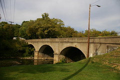
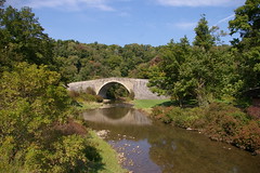
Everyone knows the famous Casselman River Bridge, the longest single span stone arch bridge in the country when it was built, now a National Historic Landmark, so there isn't much I can say about it.
I'll finish with a bridge that puzzles me a bit, the McFarland Road bridge, which sits a couple hundred feet east of Sideling Hill Creek. The wood road surface was built recently, but the stone structure is clearly much earlier. I haven't been able to locate any history for it, yet.
I could ramble more, but you'd probably rather look at the map and photographs - I think they do a better job of telling the story.
-
That storage space comment was made with tongue firmly in cheek but, as we all find, one of the few time people are likely to take you seriously is when you're trying to be funny.
Hey, it's been said that I wouldn't know humor unless it smacked me in the face. Then again, if it smacked me in the face, I probably wouldn't find it funny, either.
-
Welcome aboard, Christopher! You are providing great information - as you can see, it is much appreciated by the members - we love this stuff!
I like what you did with the Google Map, and the link back to Flickr. I have been geotagging my photos using Location Stamper (we had a discussion about that when I bought my new GPS)....it is such a time and "brain" saver when I'm trying to figure out just where I took certain photos - that aren't obvious, anyway. I just use DeLorme SAHH to track our trip, and use the GPX file to geotag the photos in Location Stamper.
I noticed that the coordinates for each location are available in Flickr...once you click over to the Flickr site, then click view on map, and the coordinates are available down on the lower right of the pop-up map.
Jennifer,
I'm glad to finally find some people who find this information useful.
I don't have a GPS and probably won't get one anytime soon - goodness knows I don't need another gadget getting in my way. I've had pretty good luck with figuring out where I took photographs based on maps, aerial photographs, and occasionally other documentation. With the exceptions of the photographs of some downtowns, my geotags are generally quite accurate - though in the areas with lower quality satellite imagery, like southwestern Pennsylvania, the quality of the geotagging goes down with the quality of the satellite photos.
- Christopher
-
A most impressive collection of photos.
Strictly speaking, markers east of Cumberland were not on the National Road but that doesn't make them less interesting. I was aware of (and have visited a few of) the markers near Baltimore. Adam Paul covers some of them here. They pre-date the National Road by several years. I'm guessing that most of the stones between Frederick and Cumberland (which I haven't seem) are from the Cumberland Turnpike which I believe was built about the same time that the first phase of the NR was being built. Of particular interest are the two stones just east of Cumberland (5MtoC & 6MtoC) which are a different shape then the other MD state stones. Possibly a different turnpike company.
You've touched on the large number of reproductions in Pennsylvania. I recall being truly impressed by what I took to be a long string of preserved and consecutive markers only to find that many were fiberglass reproductions. As you compile your catalog, noting which are original would be quite useful.
I'm not sufficiently familiar with either Flickr or Google Maps to access coordinate information. Is this possible?
I believe there are only two original NR markers left in Indiana and none in Illinois so it won't take a whole lot of storage space to document the last two states on the road.

Denny,
I agree that it is important to differentiate between original and replacement milestones - I should have been clearer in the key to my maps. Blue flags represent original milestones, whereas light blue / aqua flags represent replacements. Red flags represent stones that either do not exist or that I have been unable to locate. If you click on a given flag, a picture will come up. If you click on the picture, you will be taken to the Flickr page.
As for the milestones leading to Cumberland:
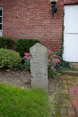
It is my understanding that milestone 9 M to C, which is in the Allegany County museum, is also of the same format, however I haven't been able to photograph it yet - it was closed when I was there last.
Also, if it is easier to browse, I have sets on Flickr of the milestones in (original) geographical order, from east to west, though some cleanup is needed (new photographs have just been put at the end, rather than being ordered correctly). The sets are here for Maryland, Pennsylvania, West Virginia, and Ohio.
As for coordinates, I don't know off hand of any way to extract them from Flickr or Google Maps, though I'm relatively sure that they're out there, for Google Maps. I'll look into that.
Storage space isn't really an issue - for my yearly subscription to Flickr, I get unlimited uploads and downloads - it's getting the time and money to travel - if anyone wants to give me a reasonable (frugal, even!) stipend, I'd be happy to document the rest of them.
- Christopher
This is saving me sooooooooo much research for when I make the trip out east!Jim,
If you really want to go crazy, I've downloaded all of the USGS topos from Baltimore to Vandalia - I could burn you a copy onto a CD and mail it to you.
- Christopher
-
Due to popular demand, and to fill the need of the masses until I'm able to come up with a more complete, descriptive set of maps that detail all the points of interest, I'm offering this set of maps, using Google Maps, that show the best way to follow the route of the National Road in Maryland. They are not completely exhaustive, but rather, they show the route to the extent that the software will let me. From Baltimore through Sideling Hill (about 5 miles west of Hancock, Maryland), they follow the original route of the road rather exactly. West of there, there are a few detours.
There will be more later, I promise - how else would you find all the stone bridges hidden on the road in Howard County, Maryland?
-
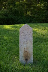
The National Road, in the United States, followed a tradition present in the UK and elsewhere of using milestones to mark the distances along the road. The Congressional act that provided funding required some sort of regular marking of distances, and thus came to be the milestones that we have on the road today. As I've shown in my earlier posts, many of the milestones have survived. However, in some places, for various reasons, the milestones have been destroyed or gone missing.
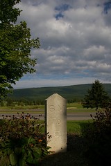
Between Frederick and Hagerstown, Maryland, some missing stones have been replaced by nondescript ones cast of concrete, like these two, 56 M to B and 58 M to B.

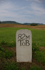
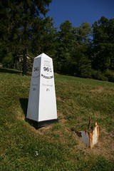
Farther west, at the east end of Clear Spring, Maryland, a beautiful little National Road town, we come to milestone 82 M to B. The top of the stone is not a perfectly rounded like the others - there is a bit of a flourish to the design. The text appears to have been sandblasted into it.
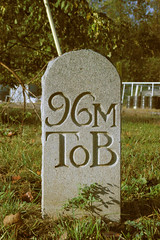
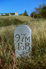
Milestones 96 and 97, in Hancock, Maryland, are carved from stone. The stone is similar in shape and size to the stones that it replaces, but is a harder material. I'm not sure what the history is behind these stones, but they are clearly recent replacements, an acknowledgement of the town's tourist economy, both past and present. (Note: both stones are, in fact, the same size.)
In Maryland, west of Cumberland, Pennsylvania, and West Virginia, the milestones are made of cast iron, poured by local foundries. The missing milestones in Pennsylvania have been replaced by ones moulded from fiberglass, while those in West Virginia have been, depending on how one reads it either restored or "re-cast". The fiberglass replacements cost about $500, a tenth of the cost of a cast iron replacement.
While I understand the economy of the fiberglass milestones, I think that something is definitely lost in their use. Further, there's something appealing about the rusty cast iron milestones, with the weld marks showing where they've been hit by automobiles. When the fiberglass ones are damaged, they can simply be replaced - what history is there there?
I think the approach taken by Clear Spring is an excellent compromise - their stone has the look and feel of a milestone but with a somewhat more justifiable expense than the cost of carving one of stone. I also think that before seeking out replacements, a greater effort should be made to find the orignial milestones and put them back by the roadside, rather than moving them to museums. I'm sure that many are sitting around in people's back yards, waiting to come back to the road.
- Christopher
-
Christopher,
More great stuff! Now I want either GPS coordinates or a map like your milepost map. I want to put these places in my mental archives for a future trip.
As a complete aside, but one we "discussed" via personal message...I really appreciate the photos. And you have introduced what appears to be a terrific compromise that maintains access to larger images while quickly downloading “supersized-thumbnails”.
Correct me, but it appears you are "inserting" smaller scale photos from your Flickr account, thus permitting "super-thumbnails" that download quickly and yet give me access to full sized images at Flickr. I like it! I will try it myself. Any advice?
Keep the Show on the Road!
Thank you.
I do love working with pictures and maps - if I could, I'd use even less text, but one must explain the pictures somehow.
I'm not so sure about another map - though I plan to eventually do a set of maps for those interested in driving the National Road, that time isn't yet - however, if you look at the Flickr page, you'll find that virtually all of the photographs are geotagged, so that if you click on the map link on the photograph, you can see where it was taken. Now, if there was an easy way to transfer the map data from Flickr over to Google Maps...
Also, you can can the location of every single photograph in my National Road set here if you are so inclined.
You are correct with regard to the use of Flickr thumbnails. What you do is take the filename of the thumbnail on Flickr and then put it inside a link to the photo page. For example this code:
[url=http://flickr.com/photos/cbustapeck/1246739960/][img=http://farm2.static.flickr.com/1221/1246739960_77ad7e4813_m.jpg][/url]
gives us this:
-
The Harvey House, a former inn on an old alignment on the east side of Sideling Hill, was built in the first quarter of the 19th century.
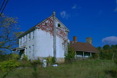
The Oliver House is a mile or two east of the Harvey House. It appears that the rear (stone) wing was built in the last quarter of the 18th century. It was used most recently to house the migrant workers who labored in the surrounding fruit groves, though it appears to be abandoned. It has nice lines, and if it were for sale, it's the sort of place that I'd be crazy enough to want to restore. Earlier photographs show a chimney inside the house at the same end where the concrete block chimney is now.
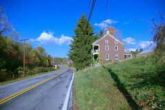
This house, a bit closer to Hancock, appears to have an interesting history as well, though I haven't been able to learn anything about it.
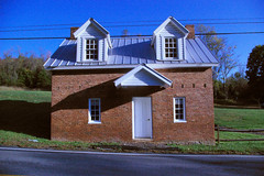
This toll house sits about a mile west of Hancock, Maryland.

The Oldest Speed Warning Sign I've Ever Seen, Revisited
in National Road / U.S. 40
Posted
Chris,
That's it! It's not nearly so fun of a story - but it's great to know, and now I'm wondering where the service station was.
The closest building of any size in the right direction seems improbable, but not impossible. It's a couple hundred feet down the road.
In the wrong direction (given the orientation of the sign), at about the same distance, we have this former service station:
Heading in the proper direction, given the orientation of the sign, there isn't another former service station for a good four or five miles. Guess I may have to spend some more time on the road.