


Michael Ballard
-
Posts
129 -
Joined
-
Last visited
-
Days Won
17
Content Type
Profiles
Forums
Gallery
Blogs
Calendar
Everything posted by Michael Ballard
-
 The structures are being removed as a new interchange is being built with Empire Ave and I-5 to south. San Fernando Road/Blvd is going to go back to its pre-1941 route and the North Burbank UP will no longer be needed.
 -
Caltrans is replacing the San Fernando Blvd bridges near I-5 in Burbank. The result will be a new interchange at Empire Ave and the removal of the old North Burbank UP and structures. The North Burbank UP, a series of structures built in 1941-42 is being closed permanently on May 20, 2014. San Fernando Blvd will be closed for a long period of time as well. While I knew about this for some time, I didn't know when it would be. I rode my motorcycle up there on Tuesday and shot video of the entire area. I posted those videos on my website at - http://socalregion.com/north-burbank-oh-videos/
-
Hello all, it has been a while. I've been working to update and expand my US 99 website recently. The link has changed as well. I've moved the former scvresources.com and sdrocksnroads.com sites to socalregion.com. The old domains will be retained indefinitely and now forward to the new domain. As to the US 99 pages, I've added more old photos, maps, and extended the tour to near downtown Los Angeles. The new link is: http://socalregion.com/highways/us_99/ My US 6 tour has also received some much needed attention as well.
-
There isn't any connection to my knowledge other than the time period they were built in. I'll be posting more photos from other trips once I go through them. I also have photos of old US 40A at Lake Oroville.
-
Hello all, I'm working on posting some of the photos I took of old US 99 in Lake Shasta when it was low in October 2008. I have posted some in my travel blog. Come check them out! http://cxmichael.blogspot.com/2013/03/us-99-in-lake-shasta-october-2008.html
-
I've been known to walk old alignments with a few feet of snow burying them. For old US 99 and US 6, there is barely a section in Southern California that I haven't walked, bicycled, motorcycled, driven, or even... kayaked. So, keep on looking! You never know what you might find.
-
Thank you for the plug for my bike tour. I did post photos of many things US 99 on it (and Columbia River Highway). The other section of single-slab I found was at Tucker Rd. There was also some concrete where Jackson Hwy split from 505 near Toledo.
-
I added a link to the Pacific Highway site on my US 99 tour. Very well put together site!
-
I went back through my photos from my 2009 bicycle tour and I did see that section of 99 pictured. I found a few stretches like that in the area.
-
You can add a fifth "bridge" to that list. The culvert behin the 1915 bridge is from the 1950's. The grade above is the US 99 expressway alignment, finally bypassed in the 1990's by current I-5.
-
The sign looks similar to the ones used in California. They are small, though usually black / white only. Older signs had yellow on them as well. Beyond that, I can't really help.
-
Well, I rode 99 and enjoyed just about every mile. Plenty of concrete to see, bridges, and towns. Here is my online journal: http://www.crazyguyonabike.com/doc/5240 Enjoy.
-
I saw that place on my bicycle tour. It has definitely seen better days. When I passed, it didn't look open. Then, I was also just happy to have gotten to the top of the hill!
-
In keeping with my new bicycle tour every year policy, summer 2011 will be my Oregon US 99 tour. I will start in Portland and end in Dunsmuir, CA. I've outlined the route, but no date is set. I figure it will take about a week or so. Anyone interested in coming along?
-
Ok, figured out an alternate south of Tacoma. I'll be heading through Steilacoom and Dupont, in leui of 99. It takes me away from a longer stretch of I-5, which I don't want to ride. I also will be taking the Interurban Trail from Everett to near Shoreline, then mostly Fremont to Seattle. Other than that, I plan to follow 99 as best as I can. So, how can I get a hold of you when I'm in Olympia? I'll have a 67 mile day before Olympia and a 69 mile day leaving Olympia. As I'll be wanting to get on the road, Tuesday evening is probably better, or an earlier breakfast on Wednesday.
-
Tunnel Off Old U.s. 99 In Ca.
Michael Ballard replied to Boy Named Sioux's topic in Bridges & Tunnels
I should read these things more often! There are two tunnels visible. One is in Piru Gorge, the other in Osito Canyon. They are both adits to the Angeles Tunnel. That tunnel connects Pyramid Lake with Castaic Lake, which are a part of the California Aqueduct - West Branch. Hope that clarifies. -
Dry Falls, Just Off the Yellowstone Trail
Michael Ballard commented on Keep the Show on the Road!'s gallery image in Member's Gallery
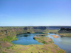 Nice photo. The Missoula Floods were truly beyond imagination. Not only are those falls as large as they are, but they were still a couple hundred feet underwater during peak flow. When you talk of cubic MILES per hour versus cubic feet per second... the scale is just enormous. Things like that make geology all the more fun for me.
 -
I still haven't visited the town as yet, gotta cover US 40 across Nevada at some point. I at least have US 6 and US 50 done (yes I took both Carrolls and New Pass). And to make another connection, Tales of the City was to take place in San Francisco, the former terminus of US 40, which Winnemucca is sited along.
-
What Do You Do To Make Your Road Trip Earth-friendly?
Michael Ballard replied to beckyrepp's topic in Polls/Surveys
I bicycle a lot of roads (I mean not just local ones), going on a full road trip by bicycle, and have a car that gets around 30 mpg. So, that would count as being more earth-friendly. -
It was also the town that "Mother Mucca" had her brothel, from Tales of the City.
-
Ridge Route Alternate - Fire
Michael Ballard replied to Michael Ballard's topic in Pacific Highway / U.S. 99
Sorry I haven't updated this information. The Piru Creek Bridge suffered only a minor loss of railing on the south end. One section. The rest is quite intact. Other than that, no major damage to the highway, which is quite nice. Now if the movie people don't cover the roadway with any more skidmarks, I'll be happy! You can thank that last Fast and Furious movie for the largest amount of marks on Three Mile Grade. -
I should also add, the dates: Lv Vancouver, BC on Aug 2 Ar Bellingham - Aug 2 Seattle - Aug 3 Olympia - Aug 4 Castle Rock - Aug 5 Troutdale - Aug 6 Hood River - Aug 7 Gresham - Aug 8 Lv Portland - Aug 9
-
I will have to keep in touch with you then. I'll be staying at the Chez Cascadia hostel in Olympia. I don't know how long I'll have, either the day before or the next morning. It all depends on how the weather is and how things have gone the past couple of days. By then, I'll know my pace. As to the roads I will be taking, I have that pretty much figured out. What I'm more looking for are older alignments that may not be obvious to me, off of the main road. Parts of 99 I won't be travelling because they aren't cycling friendly, but most of it I will. As to the Columbia River Gorge, it was the impetus for the trip. I had planned to ride only that, but after realizing I couldn't make a week out of it, I decided to add US 99 from Canada. I plan to see as many of the old bridges while they're still here. I've seen too many replaced lately, before I had a chance to see them. This may be my last time to see the Alaskan Way Viaduct, having driven it both directions in 2006. I have a regular itinerary established, rooms reserved, and train tickets in hand. There are still a couple of things I need to work out, mostly involving the bicycle. See you in August!
-
Hello all, Well, its getting closer. Starting July 31 and ending on August 10, I will be touring old US 99 from Vancouver, BC to Portland, OR by bicycle. I will be staying in Bellingham, Seattle, Olympia, Castle Rock, Troutdale, Hood River, and Gresham. The last part of the trip, as the cities suggest, will be following the Columbia River Highway (US 30) to the Rowena Loops, then over the Mt Hood Highway back to Portland. I will post more information as it gets closer. I'm still looking for advice about alignments and bridges I must see. I'm also looking to finally meet some of the Highway 99 people in Washington. Oregon US 99 will be ridden most likely in 2011.
-
That signage also extends to Santa Clarita, still along Sierra Highway. There are about three signs, one near the north end of the city, one at Solemint Junction, the last at the south end of the city.