


Texaco Fire Chief
-
Posts
43 -
Joined
-
Last visited
Content Type
Profiles
Forums
Gallery
Blogs
Calendar
Posts posted by Texaco Fire Chief
-
-
 The Sideling Hill Exhibit center will close 8/31/09 for good, Md. state officials will not fund this facility "even if there is a remarkable turnaround" in the state's economy.
There is a proposal from the town of Hancock to move the exhibits and other materials there, but nothing has been offered as a location.
This is really all about the salaries of the 4 employees that worked there ($110,000/yr.). The local officials tried, but it is difficult to coordinate a "rescue" of this facility when every local jurisdiction is "broke".
It is distressing that in less than 20 years (facility opened to great fanfare in 1991), what was considered valuable and necessary is now going to be another empty building.
It seems to me that this country faces a time in the future where no one will care about this country's history or culture, the younger generations (X,Y,and the millenials) already show nothing but apathy and ignorance...

-
Latest news is mixed. The state has agreed to fund Thurs-Sun. operations until 9-1-09. Local interests have until 8-21-09 to find alternative funding, however Allegany and Washington Counties' commissioners have nixed using any general funds to operate the center.
Tourism and business interests are optimistic that the local motel/hotel tax can be tapped for limited operations, at least until the supporters can find permanent sources of funding.
The local school districts have also weighed in; seems this is a popular destination for schoolkid field trips.
To read more, go to Heraldmail.com.
-
 Any National Road/US40/I-68 traveler may be interested in the proposed closing of the Sideling Hill Exhibit center on the east slope of Sideling Hill. This is because of MD.'s budget crisis, however an effort has been started by the Town of Hancock and Allegany and Wash. Cos., to try to save it.
The rest rooms, parking and scenic views will remain...
-
A recent ride along US 22 between Altoona and New Alexandria,PA. revealed that the long-term construction project is well along, and soon some of the original alignment between Ebensburg and Blairsville will be gone.
A nice website dealing with some of these changes is stuffthatsgone.com, which also has other US22 material, plus much more abandoned infrastructure in the southwest PA. area.
US22 (aka William Penn Hwy.) is mostly ignored because of the Lincoln and the NR, but it certainly has its interesting parts...
-
In Nov. 2008. Maryland Public Broadcasting (MPT) premiered its new documentary, "Moving Maryland Forward" the history of MD's roads. Made for the 100th anniversary of the State HWY. Admin., the documentary takes a wide look at the development of a statewide highway system, with appropriate coverage of National Road, US 1, 40, 50, etc. The program was repeated in March, with more viewings later this year.
At the end of 2008, a companion hard-cover book to the documentary was released with limited distribution, I am happy to say it is now available via Amazon. It is pricey ($50), with a leftward slant to controversial subjects, but worth it for some of the great photos, stories, and anecdotes.
I would recommend this for anyone interested in MD's roads, residents should check their local libraries to see a copy.
-
Since there was no Maryland ads in the magazine
I would like to make any future traveler to MD. aware of visitmd.org, and its free travel kit. One can choose up to 9 free brochures on MD attractions, the Historic National Road fold-out map and guide is a must for MD NR devotees. There is also a separate 'scenic byways' brochure which describes many other 2-lane roads in the state.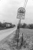
-
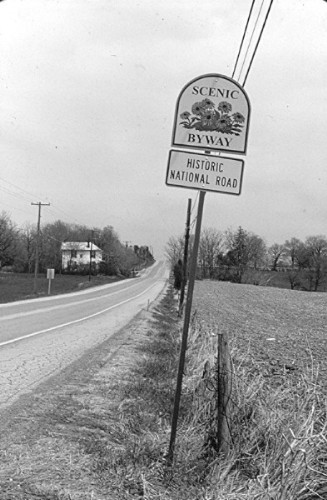
 Photos of this sign, along with other Sideling Hill west slope scenes in B&W are posted in the member's gallery.
I should mention that I do have color shots of many of the scenes and can scan them for future presentation if desired.
-
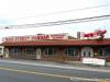
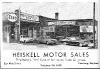
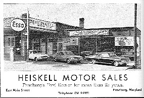
Top photo is Denny Gibson's
Bottom photo is dated 1962 and is courtesy of the Frostburg Museum, of which I am a member.
The auto dealership was gone by 1970. and it was used for storage until conversion to a hardware store in the early 90's.
-
The first 10 posts to my B&W National RD. gallery have been made, with additional entries to come. Other new gallery albums are also on the way!
Warren Jenkins
-
What is the "RT40 road group" is this a forum where there are actual conversations?
-
Anyone ever ridden either of these in the above states? US 50 is full of old alignments and interesting infrastructure from Paris,VA. to the VA/WV state line. It's then a rugged mountain 2-lane all the way to Clarksburg,WV. From there to the Ohio River, the signed route is 4-lane, but there are many bypassed alignments and small towns.
US 340 only goes from Frederick,MD. to just west of Stuart's Draft,VA. (US11), but it's MD. original route (MD180) has some interesting sights between there and Harper's Ferry,WV, where you can literally drown in history. The WV section is relatively short,and the road gets really neat between Berryville and Waynesboro,VA. Lots of buildings, old alignments, small towns, and the beautiful scenery of the Shenandoah Valley. I had a chance recently to photograph a bypassed bridge north of Luray.
Warren Jenkins
-
Jim, you are correct that the pavement is c.1930, I was just stating that the program started some 10 years before. From studying the Feldstein and Spitzer postcard collections, it appears the NR in Garrett County did not get this treatment until the early 30's. No doubt the onset of the Great Depression slowed Maryland's road improvements for a few years. I plan to post pics of a section with this style paving near Licking Creek (Indian Springs,MD.) that was abandoned in 1939 and is still well preserved.
Warren
Did I mention that I'm a postcard nut?
-
This little bit of pavement, circa 1930, is sitting right out in the open along the National Road west of Hagerstown, MD.
Here's a map link to the spot:
Jim, I believe that is from around 1920, a 1921 MD. State Highways book I've seen refers to this to this type of paving as being applied to major highways in the state. Certainly this pavement is a guide to the original path of the NR in many locations, the most intact sections seem to be those bypassed or abandoned before WWII. Much of the NR in Maryland between Hagerstown and Frostburg was bypassed or repaved with concrete in the 30's-40's to "modernize" US40.
Warren Jenkins
-
Warren, that angle on the Wilson bridge seems to be the one everybody finds! I found it myself, and after I took that shot, I started noticing how many published photos were taken from the same place!
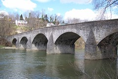
Jim, from a photographer's viewpoint, that is the least obstructed view, with easy access and good light throughout much of the day. I shot this thing from all angles, except from the newer bridge, which seemed a bit risky...
I also tried to get the old overlook view looking eastward from the hillside, but this was impossible because of trees and houses.IMO, it is also better to shoot the bridge in low water, since the creek can pile up debris on the upstream side during and after high water.
Warren Jenkins
-
Warren,
Definitely an “old timey” photo! If you “photoshopped” the house on the left a little, you would expect horses and coach to be crossing any time!
I bought a roll of B&W last week to run through my old Nikon F....mostly to check shutter speeds....but now I will have to look for suitable subjects! I am inspired by your shot!
BTW, you will soon discover that the allocation for photos on site is limited. I’d hate to have your excellent photos not get shared. You will soon need to use the gallery here, or a service like Flickr (free), or your own paid server. We stand ready to offer all the free advice you want…..and since I haven’t welcomed you yet….WELCOME!
Dave
Keep the Show on the Road!
Thanks Dave, I did notice that fact after I posted. I will probably opt to using the gallery, especially since I am in the process of scanning the other 30 B&W slides from that 2001 "experiment"
I was very satisfied with B&W film in pursuit of this hobby; in 2004 I used Kodak ASA400 to shoot the Hancock-Sideling Hill section, I also shot the same scenes with ASA 200 color film.
With my Nikons and B&W film, I try to bring back the nostalgia you get from looking at old photos or postcards.
Warren Jenkins
-
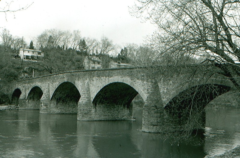
In April of 2001, I experimented with a roll of black and white slide film rated at about ASA 200. Although cost did not allow a repeat, some interesting results were obtained when I shot some National RD. subjects between Middletown, MD., and Indian Springs, MD.
Here is the famous Wilson bridge, seen here from the east side of Conococheague Creek.
Warren Jenkins photo

-
Very interesting trip, Denny! Was this your first encounter with the Western MD. Scenic? Your video was good!
You have 2 choices to reach Brush tunnel; ride the train or use the trail (walk or bike) the tunnel is about 1.5 miles west of Cash Valley Rd.As you saw on Proenty Rd., the railroad sets high on some impressive fillwork. Climbing up from there may have involved ticks, snakes, sticker bushes, etc.

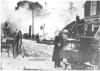
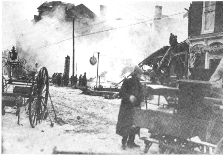
Finally, it's a good thing you stayed at the Gunter on Sat. nite, this a.m. just after midnite the building at 1 West Main St. that housed Gianni's Pizza was gutted in a 4-alarm fire that lasted into the morning. The Gunter is 2 buildings west of there, and was evacuated during the duration of the fire. The hotel itself suffered no direct damage, but was a close call. The building that burned was a 1919 replacement of a building that burned in December 1917 along with a block of stores. (Everything was leveled between the Catholic Church and the Gunter) Most of Frostburg's business district has burned at various times since 1874.
There is a good multi-media report on your4state.com (Hagerstown,MD's. NBC affiliate)
Warren Jenkins
Attached is an old photo of the 1917 fire with the Gunter in the background.
WWJ collection
-
Very nice photo-journalism!
I am fairly sure the Gilpin Rd. section of the Nat'l RD. was signed as MD. 144 until at least the opening of the I-68 segment known as the "missing link" around 1990. I do not know why it is in such good shape, but I'm grateful!
-
Hello, I'm a new subscriber to the magazine! This appears to be a growing "hobby", with a lot of info to share. I grew up in Frostburg, MD. on the National Road (1960's-70's), our family's house overlooked the road at a major intersection in town. Later we lived on top of a hill which allowed me to see Alt US 40, 'New' US 40, and I-68 (aka US48).
Besides an interest in all kinds of transportation, I have been a lifelong railfan/photographer, and for about 20 years I have been a serious fire apparatus photographer. I have had 2 fire service histories published by Arcadia Publ., along with several other magazine articles/photo features.
I really like exploring old highway alignments, and also infrastructure, from bridges to gas stations. My 2 favorites would have to be the Natl. RD., and the Lincoln Highway, but I have found many interesting routes in both MD., and PA. My photo efforts have been dormant lately, but in 2001 and 2004 I did try to photo-document the Nat'l RD./US40 from Middletown,MD., to Town Hill.
My screen name is a tribute to a great product/co., which not only enjoyed my family's loyalty for years, but also provided a career to a relation. "The Man who wears the Texaco star" was a familiar sight in our neighborhood and wherever we traveled. (Who could forget Texaco road maps!)
I would be interested in discussion of anything National Road related especially.
'Texaco Fire Chief'
Warren W. Jenkins
Thurmont,MD.

Random Rant - Brownsville, Pa Is Haunting Me...
in National Road / U.S. 40
Posted
Some historical info can found at brownsvilleboro.com, follow the link to an archive of newspaper columns concerning Brownsville, and at brownsvillepa.net, which has several pages.The wiki for Brownsville has 1 interesting fact: the population was over 8,000 in 1940, it is only a little over 2,000 now.
While Brownsville experienced its 1st boom from the NR, it was also the head of navigation on the Mon River for many years, the steamboat building trade was very active. The 2nd boom(early 1900's) came from coal mining, coke ovens, and railroads all tied to the Pittsburgh steel industry.When that industry died in the late 1970's, much of the Mon valley from Brownsville to Pittsburgh fell on hard times.
In 2001 and again last year, I visited the 2 Volunteer Fire Depts.in Brownsville to photograph their apparatus and find out about their operations. These 2 companies use both fundraising and whatever gov't assistance can be found to maintain their stations and equipment. IIRC, 1 of the chiefs is the code enforcement officer, also gov't grants have paid for building stabilization, a new fire engine, police assistance, etc.
Another fact of interest is that the crime rate has been cut in half in 10 years, it was evident in 2001 that Brownsville had a "problem". Any serious effort to market what's left of this burg as an NR mecca will depend on visitors being safe.