mga707
-
Posts
328 -
Joined
-
Last visited
-
Days Won
4
Content Type
Profiles
Forums
Gallery
Blogs
Calendar
Everything posted by mga707
-
 Hello all: If anyone is interested I have just posted pictures in a new gallery of a short (from Tucson) road trip I took a few days ago to check out the original alignment of what was Arizona State Route 86 from 1936 (when the route was established) until about 1941 or 42 (when a new, paved alignment through Texas Canyon was completed), between Benson and Willcox AZ. What got me interested in this is that I recently was checking out old Arizona highway maps at the University of Arizona library and I noticed that the original dirt alignment went through Dragoon and Cochise (both tiny communities between Benson and Willcox) while the later (and still current via Interstate 10) alignment bypasses both communities to the north. The old alignment between the two little towns is still mostly unpaved to this day, as the current paved route runs east from Dragoon to US 191 and thence N/NW to Cochise. The old dirt alignment runs from SW to NE along the UP railroad tracks and is called Manzara Road today. From Cochise to Willcox the original route continued to run directly along the tracks, through a corner of the Willcox Playa (dry lake bed). East of US 191 (formerly the infamous 666, and before that AZ SR81) the original alignment is no longer accessible as it is behind fenced land. It entered Willcox via Railroad Avenue which, no surprise, is the road paralleling the tracks! Hope you enjoy a handful of shots I took on a beautiful cloudless spring day, in the galleries!
 -
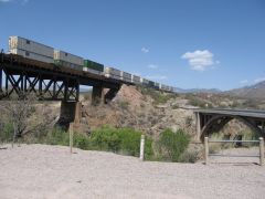
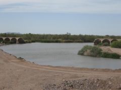
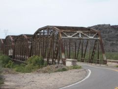
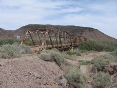
Photos of the original SR86 alignment between Willcox and Benson AZ, via Cochise and Dragoon. This alignment of 86 existed from 1936, when SR86 was established as a US80 'cut-off' in SE Arizona, until about 1942 when the present 1-10 alignment through Texas Canyon was completed. This original alignment was not paved, and parts remain dirt to this day.
-
-
From the album: Old Arizona State Route 86 alignment
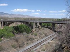
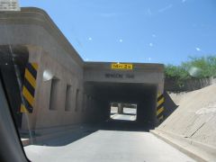
The state route 86 underpass in Benson was completed in 1941, which was just about the time that a new, fully paved alignment of 86 was completed through Texas Canyon between Benson and Willcox, bypassing the tiny communities of Dragoon and Cochise. This is the same alignment that Interstate 10 follows today. -
From the album: Old Arizona State Route 86 alignment
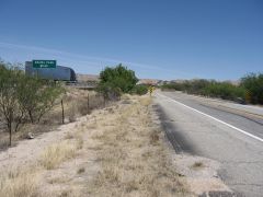
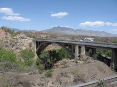
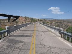
West of Dragoon the old and newer 86 alignments met near what is now the Dragoon Road exit off of Interstate 10 (Exit 318). From there until exit 306 (Pomerene Road) 86 has been swallowed by 1-10. A section of what was 86 still exists as the south frontage road for about two miles east of Exit 306, dead-ending just east of this old bridge over Adams Peak Wash. -
From the album: Old Arizona State Route 86 alignment
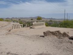
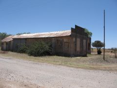
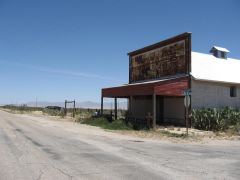
Just as in Cochise, there is an old abandoned 'general store'-type building in Dragoon as well. -
From the album: Old Arizona State Route 86 alignment
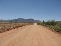
Looking much as it must have 70 years ago, the old 86 alignment following the RR tracks between Cochise and Dragoon (Manzoro Road). -
From the album: Old Arizona State Route 86 alignment
View to the southwest down what was the original alignment of State Route 86 toward Dragoon. The pavement ends a few hundred feet ahead. -
From the album: Old Arizona State Route 86 alignment
-
From the album: Old Arizona State Route 86 alignment
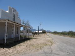
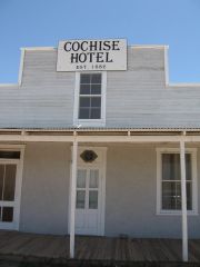
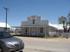
Next door to the store in the previous picture stands the historic Cochise Hotel. At present it appears to be closed, but it was open for guests until quite recently. To my back are the former Southern Pacific RR tracks (now Union Pacific), which the original 86 alignment followed from Willcox to Dragoon. -
From the album: Old Arizona State Route 86 alignment
-
Very true! And as an aside, after a few 'near misses', it quickly became SOP to keep to the right side of the track being followed, just in case another railroad-following aviator was intently looking down while coming the other way at the same altitude!
-
Actually, following the railroad was even more common in the early days of aviation than following a highway, as the rails were much more prevalent! These neon-lighted towers actually had a very short operational life, as radio beacons had come into full use by the time that the Boeing 247/Douglas DC-2/DC-3 were in commercial service from 1934 on. The decade of the 1930s was an amazing one of technological advancement in aviation! I wonder how long Richfield kept the neon 'on' at night on these great period artifacts?
-
Better Than A Bridge By A Dam Site!
mga707 replied to Keep the Show on the Road!'s topic in Bridges & Tunnels
Yes, the road across the dam was closed either at the time of or shortly after the Laughlin/Bullhead City bridge across the Colorado (AZ SR68/NV SR163) was opened in the 1990s. The road on the AZ side of Davis Dam continues northward to several coves/boat launch sites on Lake Mohave (the lake formed by the dam), but the road on the NV side goes no further than the dam. -
Loved the marquee of the Lee Theatre in Ephrata, picture 199: "Monsters vs. Hannah Montana Fast and Furious"! My money's on Hannah....
-
Wow! Once again, GREAT photo essay of your trip, even with the battery dying before the end. Hope you didn't actually have any faceless children nightmares!
-
"The World of Coca-Cola". Isn't the very first Waffle House still open in one of the Atlanta 'burbs?
-
Your photo essay is absolutely great! What great pictures, and what a fun trip you and Smartz had!
-
I do thank you, sir!
-
No, I tried that as it seemed to be the obvious path. Clicking the blue "options" button brings up two choices: "Edit image" and "Report image". No "delete" option in either one of those, either.
-
You are partially correct. Like most concrete dams, Parker Dam is horseshoe shaped if looking down from above. The pictures from both the AZ and CA sides are indeed of the same (downstream) side of the dam. But this is the low water side of the dam. The upstream, unseen side would be the higher water lever side, as Lake Havasu backs up to the dam. Coming across the dam from the California side, the road does make sort of a U turn. There is no road upstream from the dam on the CA side. On the AZ side, upon crossing the dam there is almost immediately the 'T' intersection with AZ State Route 95, which one can take either to Parker (right turn, or downstream) or to Lake Havasu City (left turn, upstream). Hope this clarifies!
-
The title says it. I accidentally posted a duplicate photo in the photo gallery, and there does not seem to be any obvious way to delete it. Anyone?
-
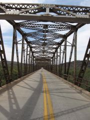
Photos of two old bridges on old sections of former US route 80 in southern Arizona
-
-
From the album: old US 80 bridges in Arizona
-
I've just added my old US 80 bridge pictures to the Gallery. Both the 1927 Gillespie Dam bridge and the 1921 Cienega Creek bridge. One picture would not upload, and one I inadvertently duplicated. Anyone know if there is any way to delete a dupe from the gallery? Anyway, hope you like them.
-
From the album: old US 80 bridges in Arizona