


mga707
-
Posts
328 -
Joined
-
Last visited
-
Days Won
4
Content Type
Profiles
Forums
Gallery
Blogs
Calendar
Everything posted by mga707
-
I just finished reading a new book that I'm sure anyone who frequents these forums will absolutely love--it's the best work of non-fiction that I've read in quite a while. The book: "Harry Truman's Excellent Adventure" by Matthew Algeo. Chicago Review Press, 2009. In the summer of 1953, during Mr. Truman's first year as an ex-President, he and Bess took a classic road trip--in their brand new 1953 Chrysler New Yorker!--from their home in Independence, Missouri, to Washington DC, Philadelphia, and New York City (to visit daughter Margaret). No advance notice to anywhere they were staying (save for the Reserve Officers Association convention in Philly that Harry had agreed to address), no Secret Service protection--ex-prezes didn't receive that perk back then, and no AC in the Chrysler! The author recounts Harry and Bess' trip, and retraces the exact route in the present time (2006-2008). The writing style is excellent, and once I started the book I did not put it down until I was finished. A great reminiscence of the pre-Interstate days of road travel that we celebrate on here, and a reminder of how much has changed in the past 56 years. Read this book--you'll love it!
-
 Hi Dave-- Unlike some tribes in Arizona (the Hualapai, for example), to the best of my knowledge neither the Navajo nor the Hopi require 'back road permits' as long as one stays on tribal routes. As I surmised in an earlier post, the road in question is Navajo/Hopi route 7, so I don't think a permit will be required. 4WD would be good idea as the road is unpaved, and based upon my experience with unpaved roads in Navajo/Hopiland, it will have areas of fairly deep sand and, if it has been rained on recently, muddy areas as well.
 -
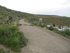
The old road from Gardiner MT to Yellowstone NP
mga707 added images to a gallery album in Member's Gallery
Two photos of the "Old Gardiner Road" which runs from the Mammoth Hot Springs area of Yellowstone National Park--the original park entrance--five miles north to Gardiner MT, west of today's US 89 alignment. -
-
From the album: The old road from Gardiner MT to Yellowstone NP
-
Information sign at the Mammoth Hot Springs Hotel cabin area
mga707 posted a gallery image in Member's Gallery
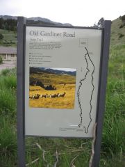
From the album: The old road from Gardiner MT to Yellowstone NP
-
Dave-- Enjoying this story! While certainly no expert, I have driven nearly all of the major roads in the Four Corners area...and a few of the not-so-major ones! After consulting my trusty AAA "Guide To Indian Country" map--a fantastic Auto Club of So Cal map that I have worn out several copies of--I will concur with your hunch that the "Motor Men" of 1917 used what is now basically the US 163 alignment to cross Comb ridge between Bluff and Mexican Hat. Can't wait to hear more, and would love to be able to be part of any future 'expedition' to find the elusive inscription somewhere south of Red Lake! Mike
-
Motorcycle Trip On The Lincoln Highway
mga707 replied to hutmo's topic in Lincoln Highway / U.S. 30 / U.S. 50
Eric-- Don't know why I didn't come across it earlier, but I finally read about your June '08 trek across Nevada tonight. Very interesting! I've never been west of Ely on 50, so it makes me want to go all the way across the state. Anyway, I read where you speculate that Carson City might be the smallest state capitol city in the US. It turns out not to be so. With a 2000 census population of over 52,000, Carson City is larger than quite a few other state capitols, including the capitol of your state, Olympia. Montpelier, Vermont, is the smallest state capitol, with a 2000 population of just over 8,000. I believer that Pierre, South Dakota is next, coming in at around 17,000. Ah, but Carson City would be quite a bit smaller if not for a trick they pulled a few decades ago (sometime in the 1980s, IIRC). They did the Nashville/Jacksonville/Indianapolis trick of annexing the entire county into the city limits. If just the urbanized area was in the city limits the population would probably be no more than about 25,000. Still not the smallest, but about half of the 'official' figure. ...and if you want to stump people, ask them what the LARGEST state capitol city is. Almost nobody guesses it correctly, unless they live in my state. It's that 'bad example' up the road, Phoenix! The only state capitol city with over a million residents, about 1.5 mil to be more specific. Just some rather useless US geographic trivia for you... -
That 1859 bridge in Carlyle is one pretty bridge! Assume it is still open for pedestrian use?
-
Another possible side trip: If you are interested in 'bagging' NPS sites on your travels (as I am), Pinnacles National Monument (east entrance) is about a 30-mile each way side trip south from Hollister (on the more southerly of Dave's two 'blue routes' above) on CA SR25. I haven't been there--it and King's Canyon NP are the two main NPS sites I have left to 'bag' in Cali--but it looks interesting. Like Colorado's Black Canyon of the Gunnison NP (and my own state's Grand Canyon), Pinnacles has two separate entrances (east and west) that are not connected by road. According to my NPS references, the east side is by far the more 'developed'.
-
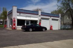 I like the juxtaposition of the old-time service station and the recent vintage Monte Carlo!
 -
Not to sound like a certain polarizing radio talker, but dittoes to the above two posts from me as well...
-
I haven't mentioned it on here before, but Ruby is well known among ghost town fans. It's a small site (nowhere near the size of Bodie CA, for example), but it is a first-rate example of a "true" ghost town; i.e., one with a population of zero.
-
There is a similar old school house at a well-preserved southern Arizona (Santa Cruz County--NW of Nogales) ghost town called Ruby. Ruby is privately owned, gated and fenced, and can only be visited by guided tour with advance notice. Which is great since it keeps the buildings preserved and the vandals and other riff-raff out! Anyway, Ruby has a similar old two-room schoolhouse, last used in the WWII years. And outside in the playground they still have the swings and a really cool--and high!--metal slide. Which you can't have today! Liability issues, you know--junior may fall off and crack open his head!
-
1. On The Trail Of The Motor Men Of 1917
mga707 replied to Keep the Show on the Road!'s topic in U.S. Highways & Auto Trails
The fall would be the best time to go, weatherwise. From mid-Sept to mid-Nov weather is usually just about perfect. From about the end of June/first of July until mid-Sept you run into the monsoon season issue, and all travel on unpaved rez roads should be done in the AM. They can become mudbogs very quickly if a summer afternoon thunderstorm dumps on them! -
1. On The Trail Of The Motor Men Of 1917
mga707 replied to Keep the Show on the Road!'s topic in U.S. Highways & Auto Trails
Wow, this really makes me want to ditch work, get in the car and head due north across my state to my beloved Navajo/Hopiland! Getting out my Benchmark "Arizona road and Recreaction Atlas", and using your location as described above, it appears that said carving should be visible from Indian Route 7, a mere 6.2 miles or so from US 160. Route 7 is indeed one of the "main dirt roads" in the area. Of course, one of the charms of Navajo/Hopiland is that such "Indian Routes" are rarely, if ever, signed, and one must use ones own judgement and map skills when coming to the proverbial "fork in the road" to ascertain which fork to take! I would not imagine that this carving would be that hard at all to locate, given a vehicle with decent ground clearance and good (dry) weather. -
Me too...since 1987!
-
Somebody's simply got to 'liberate' those old maps!! Edsel's a '59, Second year out of the 2 1/2 years they were sold, and the last 'real' Edsel. The few '60s that were built were just rebadged Mercs with different trim. This one's got lots of chrome, so it's a higher-end Corsair model. Dave, that's a perfect "Car Spotter" shot for "Collectible Automobile" magazine. Send it in! IIRC, Maxwell was the failing auto firm that W. P. Chrysler took over in 1924 to found the Chrysler Corp. Now failing itself, sadly...
-
Really nice shots, Dave! The Hotel Waterville remind me of the lovely old Hotel Vendome in Prescott (AZ), although the Waterville looks substantially larger and is a decade older than the Vendome. They both have the same 'look' though, and similar neon signs!
-
No, I haven't seen it yet. Plan to pick up the DVD at some point. I do have "Horatio's Drive", which you also mentioned. Now that was quite a feat--driving coast to coast in 1903!
-
Assume you mean "Paving the Way" which is about the similarly-named but different National Park To Park Highway. There's a banner ad about it at the top of this very site.
-
...not to mention the mid-street parking! Agreed, a fine photo find! (...can one still go dancing on University Street in Seattle?) Wish I could ID all, or at least some, of the cars, but when you get pre-55 or so my car spotter skills get pretty hazy!
-
Dave--thanks for the quick reply. It is a cool sculpture, and quite "Burning Man-esque"!
-
Off topic: Dave, just curious: Is the photo in your post from Burning Man? On topic: (rant on) With the state of Illinois having to close or limit hours at these historic sites, it's really great (sarcasm) that they have had to waste so much money due to the sleazy shenanigans of Blago The Clown...(rant off)
-
Original Arizona Sr86 Alignment Between Benson And Willcox
mga707 replied to mga707's topic in State Highways & Other Roads
Warning! Thread creep! Alex, your Montana backroads trip brought back memories of my own! In summer '06 my travel companion and I did a big fly/drive upper Great Plains trip starting/ending at DEN. This was the trip in which I finally bagged states 49 and 50 (SD and ND--all 50 before I turned 50!), but I digress even further... Anyway, in order to get from Teddy Roosevelt NP in ND down to Devil's Tower NM, WY, via the quickest route, we drove through extreme SE Montana, and spent the night in Ekalaka, pop. under 500, county seat (and only real town in) Carter County! Accomodations at Ekalaka's only motel were OK, but Spartan, and the following morning we strolled through the town (doesn't take long!) and had a good breakfast at the town's cafe, operated by a San Diego 'refugee'! Following breakfast, we stopped in at the Carter County Museum, which is simply amazing for such a tiny town! They have a fossil collection which would not be out of place at a big city natural history museum, such as the one in Denver. They have a nearly complete duck-billed dinosaur skeleton, along with lots of smaller fossil exhibits, and much more area history packed into the little museum. Doesn't hurt that Carter County is in the heart of one of North America's prime fossil areas, where any amateur palentologist can stumble upon something without too much effort. Still, the museum was an unexpected treat. Leaving Ekalaka heading south toward US212 at the MT/WY border, one leaves Montana Route 7 and is traveling on a county road which soon turns to gravel for most of the distance. Just like your experience: Gravel road, nobody else around, miles and miles of rolling grassland interspersed with wooded ridges (Black Hills outliers)...it was great! I love Montana! -
Original Arizona Sr86 Alignment Between Benson And Willcox
mga707 replied to mga707's topic in State Highways & Other Roads
Thank you both for your positive comments! One interesting 'road fact' about old AZ86 was that both it and another early Arizona state highway--AZ84 between Tucson and Gila Bend--served as US80 'short cuts'. 86 ran from Benson to Road Forks, NM, just east of the AZ/NM state line, and 'cut off' a huge section of 80 that headed southeastward at Benson to go through Bisbee and Douglas down by the border before looping back northeastward again. Similarily, 84 ran northwestward from Tucson to Casa Grande and then turned due west to Gila Bend (just as I-10 and I-8 do today) while 80 took a much more leisurely routing north and then west through Florence, Mesa, Phoenix, and Buckeye before heading southward to Gila Bend. I have a feeling that this original alignment of 86 between Benson and Willcox was always intended as temporary, since it was bypassed only a half dozen years or so after the route was first established. Also, I'm sure that getting the highway out of the dry lake bed (Willcox Playa) was a priority, since even though the Playa is dry 99% of the time, that other 1% can be problematic!