


DennyG
-
Posts
1,734 -
Joined
-
Last visited
-
Days Won
4
Content Type
Profiles
Forums
Gallery
Blogs
Calendar
Everything posted by DennyG
-
That's a darned nice museum and you (Dave) made it all that much better. It's always good to get your questions answered and to get some not-in-the-brochure info. I definitely recommend a visit to America On Wheels to folks who get anywhere close. I really wanted to see the 100 years of Chevy display but ended up enjoying the Cars That Were Stars display a whole bunch and I'm sure whatever comes after that will be cool, too. And the temporary display area is just a fraction of the museum.
-
On Thursday I started driving west on US-44. When it ends, I'm jumping to the east end of US-22 and following it home to Cincinnati. The reason? The world of US route numbers has room for precisely four twin-digit even numbered routes. One, US-88, never happened and another, US-66, became the most famous of US highways, but has been decommissioned. That leaves just US-22 and US-44 as the only "living" members of this exclusive group. Thursday's journal is here and journals for subsequent days will be posted as the trip progresses. The cover page for the whole trip, which necessarily includes getting to that eastern terminus, is here.
-
Essex Airfield
DennyG replied to roadhound's topic in National Old Trails Road / Santa Fe Trail / U.S. 66
Now that's off the beaten path -- and airways. Nice stuff. -
Sounds like you may have "Quickest" selected. If so, selecting "Shortest" (right side of "Route" tab with "New/Edit" selected) will help. Regardless, inserting vias (artificial waypoints) is really the only way to create the route you want. This is the unavoidable conflict that roadies have with all routing software. Over time you'll learn how to minimize them somewhat but you may still reach that limit and the only solution is dividing the route. Unfortunately, SA does not provide an easy way to do this. When I did the Lincoln Highway west from Indiana I had a separate route for each state and apparently had to break both Nebraska and Iowa into three legs. So, I believe you're basically using the correct procedure and just bumping into DeLorme's limits and the natural conflict between the path you want to follow and the one that some computer algorithm spits out. It can be aggravating but, as I said, is really unavoidable. Even if DeLorme had a "follow the alignments of 19xx" setting (Wouldn't that be cool?), you might want to insert or skip segments depending on whether you are driving your Lamborghini or your Hummer. Of course, you wouldn't have this problem if you could just be satisfied with going where everyone else goes.
-
Click the "Print" tab and select route. You can customize it with strip maps, turn by turn directions, etc. Sorry that I didn't see this sooner. Am heading out the door but will check back this evening.
-
Good news about locating an engine. I knew of the the meltdown from theoasisofmysoul.com but this replacement engine story is breaking news of the best kind.
-
Lean I'll give you but you don't look all that mean to me. Congrats on finishing the rehab.
-
Thanks all. I'm kind of new at it but, near as I can tell, being 65 is a lot of fun. Check out my birthday parade here.
-
Ahhh. I found the Old Control Road. Now that's getting into the map's fine print:-)
-
Lodging Near Dixie Highway / Lincoln Highway In Illinois
DennyG replied to BlueRidgeMike's topic in Trip Planning
This won't be exactly the answer you are hoping for but I'll tell you what I've done. Over the years I've developed the habit of stopping in Merrillville, IN, when going to Chicago. This started with business travel and continued with pleasure trips including Route 66. It's really just a standard cluster of chain stuff but it's far enough from Chicago to not BE Chicago and close enough to get downtown in an hour or so. (It should be 15 minutes but isn't ;-) It's also the right distance from Cincinnati to get to without a strain. I see that the last time I did something along these lines (2009 - Lincoln Highway) I stayed at the Super 8 there. In the past I've stayed at other bargain class chain motels in the area. I'm not aware of any mom & pops but with the LH & DH crossing near there (Merrillville is on the LH about 15 miles east of the DH) it seems like there should be some. Now I'll tell you what I've thought of doing. I've never stayed there but I've heard good reports about the Ohio House Motel in Chicago from Route 66 travelers. There are some things I'd like to do in Chicago (blues, Dave Clark tour) and spending a night or two there would make that easier than staying somewhere like Merrillville and cheaper than staying somewhere like the Waldorf. I have yet to drive the DH from Louisville to Chicago so I've thought of doing that with a little Chicago on the end. I'm half planning on doing all of 66 and attending the festival in Victorville in August and I could do a little Chicago on the front. And, of course, I've thought of doing what you're doing and doing a little Chicago in the middle. -
Are your "control road" and DeLorme's "panoramic highway" the same thing? I certainly remember "smudge pots" but also remember flashing electrics showing up about the time I was a high school senior so I don't have tons of experience driving toward them. I guess the surface reflectors you mention made a bigger impression on me. I think the technology made a big leap (or the costs made a big dive) in the early 1970s because that's when I remember them showing up as edge markers far from the city. I distinctly remember being in awe of the path that magically appeared before me as I drove a completely unlighted stretch of winding road on a dark night around 1975. I also have a memory of the earlier big advance of simply painting a white stripe along the road edge. When Ohio first did that to all state routes, some signs were posted touting the improvement and identifying the governor. I don't even remember who the governor was but I don't think my Dad liked him much. I recall him passing the signs and muttering "You'd think he got out there and painted them all himself."
-
Big welcome, Wayne. Congrats on having a family that enjoys road trips and on having the wisdom to appreciate it. My days of traveling with family are over and I now wish I'd done a lot more of it. The closest thing I have now is an occasional trip to family. If you like scenic drives and time permits, you might try a bit of the Blue Ridge Parkway. I started this paragraph intending to suggest picking it up at the western terminus in Cherokee but just checked and see that the first few miles are still closed for construction. You could reach Waterrock Knob on the section between US-19 & US-23 and those two roads aren't all that shabby either. Of course, US-441 through the park is also very cool. American Road Magazine Vol-IX No-4 (Winter 2011) had a feature piece on the Orange Blossom Trail which goes through the middle of Florida. Depending on how you get to and from Orlando, you could be on or near it. One of the many attractions mentioned is Bok Tower about 50 miles south of Orlando. I visited there for the first time in January and definitely enjoyed it. Here are a couple of things closer to Key West that don't seem to get a lot of press. Coral Castle in Miami is pretty cool but does cost money. The real African Queen can usually be seen for free at the Holiday Inn in Key Largo. There's an old sugar mill on the east coast near Daytona. I know about it only because my great grandparents stopped there in 1920. I've stopped there several times. It's got the old mill, paths running though some beautiful gardens, and even some dinosaur statues! And it's free. Apparently you have to do something (like declare it a link?) to make something clickable. You might want to look into that for the URL in your signature to help speed people to your site;-)
-
That's probably a good guess. I do poke my nose into the Route 66 Yahoo group now and then. Yep, I believe the redone signs were turned on in October. I was there the first weekend in March. I spent the night before the group cruise in Collinsville and made a point of visiting the Luna after dark. I had seen pictures from the lighting ceremony but seeing the real thing was even better. They definitely did a nice job with the sign. I just added a photo to the forum gallery here.
-
Restored signs at the Luna Cafe on Route 66 in Mitchell, IL
DennyG posted a gallery image in Member's Gallery
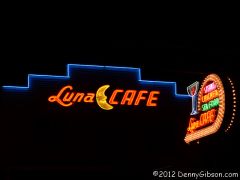
From the album: Denny G's Gallery
-
I can't help with updates at least until August when I may be in the area as part of a Route 66 festival trip. If so and time permits, I could see trying to work in a Banning-Idyllwild drive. A road that DeLorme labels "Banning Idyllwild Panoramic Highway" gets my attention. Although I have no experience with controlled roads, I definitely remember construction zones that used flags or batons to control one lane traffic. I've driven through them and worked on them as a flagman in the 1960s and, like you, I remember being thrilled in even younger days when Dad got the flag. I was sure they only gave it to important people they knew they could trust.
-
A belated welcome, Charlie. Sounds like you're doing the right stuff the right way. I, too, have a lot of states left to visit. I was in your neighborhood not too long as part of a small group that drove Sixty-Six between Mitchell and Springfield, Illinois. The group included a couple of other St Louians who stop by the forum once in awhile.
-
I'm sure everybody here truly appreciates your decision to keep your teeth and do the not-so-much-fun but necessary paperwork for the Michigan Road Association. See, it's only mostly thankless.
-
Wonderful glimpses at "real" history. (And yes, I am slow.)
-
I think you've picked a region that is terribly under represented on the forum. I've been to Niagara Falls exactly once and my own first ever trip to Boston was scuttled last year by hurricane Irene. Hopefully Alex, who at least used to live in Maine, will show up with some pointers. I have been to Lancaster a few times and always associate it with the Lincoln Highway. One possible route to Lancaster would be picking up the Lincoln Highway at Philadelphia or Trenton or sooner and following it to Lancaster or beyond. If beyond, you could include a stop at the Gettysburg battlefield. Another path would be along US 22 or I 78. That would bring you near Allentown where forum member Dave Reese is heavily involved with the America on Wheels museum.
-
Forced To Search For A New Job...unemployed
DennyG replied to knightfan26917's topic in General Discussion
Obviously that's a real kick in the head but just as obviously you're not allowing it to completely ruin your view of the world Recognizing the value of "nephew time" shows that. -
OK, so it's not American at all and it's often not even on a Road as we define the word, but it is a rousing tale of travel and it's happening right now. http://oldblokeonabike.com/
-
Welcome to the forum. That's quite a site you've put together. I was in central Florida two weeks ago and possibly could have made use of it although the Dixie Highway sort of monopolized what road time I had on that trip. Next time.
-
Surely you've heard the term "sports figure". Before we are accused of drifting off topic, I'll remind everyone that Weeki Wachee is right on the path of the Dixie Highway Tampa - Saint Petersburg Loop although the road was officially gone long before the mermaids came along. Plus, as further evidence of my own dedication to the road, I'll point out that the aforementioned Karri's hometown is the Dixie Highway village of Aripeka which I drove through on the way to Weeki Wachee. The trip that more or less wrapped up at Weeki Wachee wasn't all on the DH but the last two days (day 8 & day 9) were on the Tampa - Saint Pete Loop and I earlier mentioned day 5 as being an unsuccessful search for one of the markers in this thread's title. Days 1, 2 & 4 also contain a little Dixie Highway. I was really surprised on day 1 when I saw the Powell Airplane with an all new skin almost completely in place. I just now uploaded a picture of the plane to the forum's gallery here. Knoxville and the Dixie Highway are going to have a very nice new/old attraction very soon.
-
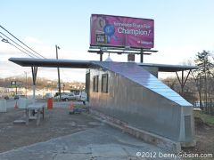
From the album: Denny G's Gallery
New skin on the 1930 airplane shaped gas station on the Dixie Highway in Powell, TN. -
I was by the Old DH/county line on Tuesday and did not find a Lee/DH marked. There is a large stone Brevard county over on the current US-1 which may have also been the DH. Possibly more interesting was Dixie Lane which runs east-west about a mile north of the county line. We followed it to its end but I figured it really was somebody's lane but when I looked at DeLorne it was labeled Old US Hwy 1. I am certainly behind but I did get Tuesday's journal up earlier today. It's here: http://www.dennygibson.com/fl012012/day05/index.htm