


DennyG
-
Posts
1,734 -
Joined
-
Last visited
-
Days Won
4
Content Type
Profiles
Forums
Gallery
Blogs
Calendar
Everything posted by DennyG
-
I spoke with my uncle again this evening and plans are forming for my being in Florida next week. I'm guessing that the marker was on the original Dixie Highway which is now called County Line Road/Dixie Way and now "gone back to dirt" according to a note on Robert Droz's site. I don't know whether the current US-1 was ever the DH although it certainly seems possible and I'll take a look there if nothing is found on the older road. Any additional clues, hints, insights, or hunches?
-
Car Thoughts, Party, Radio & 2012 Road Trip
DennyG replied to knightfan26917's topic in Trip Planning
If we haven't connected before then (or even if we have), Columbus 9/12 dinner at Roadhouse 66? And... I keep an MP3 copy of Movin' Right Along in the car at all times. -
Mike Buettner knows a lot about a lot and is a great researcher. Because of him, the Ohio Lincoln Highway League site is a good source for information on other named auto trails (e.g., DH, PPOO, NOTR) and some numbered US routes (e.g., 20, 50) in Ohio. Maybe that wizard who made us miss the Franklin marker is also keeping both of us from remembering the good stuff that is there. By coincidence, an uncle who spends his winters near Lake Alfred, FL, called last night to invite me down for a stay. I think I'll probably follow through on it and had already started thinking about what Dixie Highway exploring I might be able to do. It looks like the Brevard-Volusia County Line is well within range. I don't want to push in front of you but taking a look has certainly occurred to me.
-
Wonderful. I've stopped at Horse Shoe Camp several times but you told me more about it after one stop than I've learned in seven years. My first sighting was in 2004 when the roof was still intact and the sign still horizontal. It was still fairly straight in 2009 but was listing considerably in 2010. That plywood in your photo is every bit as new as it looks. It has been added since September of 2010. Rain kept me from stopping when I passed in December but I regret not even getting a drive-by shot. I didn't know it was on the National Historic Register. Never thought of it. I see there is quite a bit of information on the application. Did you also find other sources? Your Wigwam Village "weather report" definitely put a smile on my face. It wasn't too many years ago that it simply shut down in the winter. Then I think they decided that, if people were crazy enough to stay there in the winter (you & I both qualify:-), they'd let them. Of course, we're also crazy enough to appreciate a true classic that turns 75 this year. I've stayed at the three surviving Wigwam Villages. You started with the newest and moved to the oldest. I believe the one in the middle, Holbrook, is closer in age to the one in San Bernardino but closer to the one in Cave City in "amenities". I doubt, though, that you'll be staying in Holbrook in January. Nice to see that both Hoskins Drug Store & Restaurant and the theater next door are still operating. Did you happen to stop at either of two attractions, Ciderville Music and the airplane gas station, just a little to the south? Good stuff. Thanks for both the report and the pictures.
-
While I was thinking about visiting the Franklin monument, I dropped a note to Russell Rein to see if he could help clear up the two alignments for me. His reply was a real "duh" moment since he mentioned Mike Buettner and I recalled that Mike has a very nice article on line about the Dixie Highway in Ohio. That article is here. The report of me taking advantage of it is here. The monument was right where it was supposed to be and I believe I've now driven fairly accurate modern versions of both Franklin to Cincinnati routes. Once in downtown Cincinnati it's kind of a crap shoot but I'm going to claim having done it right at least once in the past ten years if only by accident.
-
Yeah, that day was pretty much a waste weather wise. With better weather, I'd have probably looked over Stone River Battle Field south of Nashville though I don't really know what's there. If you like old falling down stuff, you might like the ruins of Bell's Tavern in Park City and the ruins-in-process of Horseshoe Camp Motel on towards Bowling Green. The old motel is on the right side of 31W maybe halfway between Park City and Bowling Green. If something in particular interests you and you'd like better direction, I can probably come up with some. I have a "math" story from Wednesday night. On the way to a play, I stopped in a bar from my past. When I entered, I joked with the bartender that I hadn't been there in "a hundred years". I sat down and told him "I was just joking about the hundred years but I bet it has been over twenty." After a little memory and math check, I figured out it was at least 35 to 40 and could even be a year or two beyond that. Time flies.
-
I drove the Dixie Highway between Russellville, KY, and Shelbyville, TN, the week before Christmas. I know I'd driven much of it in the Nashville area before but it was "undocumented". I usually mention trips like that here but apparently missed that one. (My secretary's really been slacking.) The Dixie day is here although there aren't a lot of details. You're probably more familiar with the area than I am but I'll still mention some things that come to mind: Wigwam Village #2 at Cave City is the oldest village still standing but a store/restaurant/gas station still operates on the site of Wigwam Village #1 at the intersection of US-31E and KY-218. The road behind WV #2 is the old DH. As a car guy, you're probably familiar with the Lane Museum in Nashville and the Coker Museum in Chattanooga. If so, excuse me for being unnecessarily redundant -- again. Chattanooga is home to one of my favorite breakfast spots, Aretha Frankenstein's, and "motels", the Delta Queen. Some great 'burgers (and many other things) are at Litton's just north of Knoxville. Sounds like a wonderful time. Wish I was there.
-
Another place I remember from my one Oregon visit but there was no "...quiet walk down an empty main street..." to be had on that day. The original Becky Repp recommended Pig 'n' Pancake restaurant is in Seaside and I drove down the street to the Lewis & Clark monument thinking I might park for a peek at a pancake. Not a chance and I was happy to leave the congestion once I got back to 101. It sounds and looks like a January visit would be much more enjoyable than mine in August. Incidentally, that was the last day I could honestly tell law enforcement agents that I had never met David Paul.
-
Nice to know that the UDC did respond. The articles could certainly contain some interesting tidbits even if there is nothing about the monuments. It never stopped raining on the day I threatened to run up to Franklin and now it's snowing. Maybe I'll get there when the spring thaw breaks. "Montgomery Inn for ribs"? Hey, you're no stranger to these parts after all. And now you've awakened a craving that could just drag me out in the cold.
-
Not necessarily. There were two DH alignments south of Franklin. I'm not sure which is the oldest. If you were following OH-4/OH-73, you would have swung west just before reaching the marker. Of course, if you went directly south on the Cincinnati-Dayton Road alignment (which is actually called Dixie in spots), you have no excuse (except for the evil wizard thing). In looking at maps just now, I'm thinking that even the western DH might have originally passed the marker by turning west on Hamilton-Middletown Road rather than today's OH-73. My excuse, at least for the July pass, is that I drove that stretch northbound and the marker (as seen on Google Earth) would have been hidden by foliage. Plus my mind was probably still on the monument to the first China Poland Pig where I'd just stopped. It's about a mile and a half south. Foliage, pigs, and wizards together are almost unbeatable. Franklin is one of those towns that has split traffic onto two one way streets. The northbound route is the one that follows the Dixie so you may have missed a section of the DH and the marvelous murals that make Franklin cool. You have lots of reasons to come back. Apparently you can just edit away with no advance arrangements but I think creating an account and logging in is the proper way of doing things. Look in the upper right corner. The data does have some HTML so you need to either know a little about it or just avoid it. In this case (and in most cases) I think avoiding it is pretty natural. Since nothing that is currently said about the eight Carolina markers is actually wrong, you don't really need to change anything already there. Maybe just add something about the other two markers right after the sentence about "An eighth monument...". Find a local guide and buy him a beer. Actually you were on the right course. Vine Street being one way makes it impossible to precisely drive the DH southbound and construction near the bridge makes it tough, and sometimes impossible to drive it in either direction. First it was building the two stadiums and now it's the Banks Project which is filling up the space between. Access to the bridge isn't really blocked all that often but the various material and equipment sitting around can make it look like it is. This too shall pass or so they say. If you haven't driven the Roebling Bridge you have a really big reason to come back. It's possibly the coolest bridge on the DH and almost certainly the oldest. Construction was interrupted by the Civil War but it has been in service since 1868.
-
I've always suspected that an evil wizard lives in Franklin and clouds my mind when I drive through that intersection and this proves it. I must have driven by that marker several times (it's less than 25 miles away!) but don't recall ever seeing it. My most recent and glaring failure would have been in July when I purported to drive all of the DH twixt Vandalia and Cincinnati. I may try again today but I'll be sure to disguise myself and carry my magic staff. My first discovery of one of these markers was very much a "by golly". It was the one in Marshall, NC, and I had no idea it was there when I stopped. That was in November 2008. My only other documented sighting was in December of the next year at the SC/NC border. That one was clearly not a "by golly". I had definitely targeted the marker but I say nothing about where I learned of it. Whatever the source, it apparently had some sort of inventory because I claim that there are a total of eight and list the others in the Carolinas. The source may have been Wikipedia since it lists only those eight. Why I didn't seek out any of the others is a another mystery. Maybe there's an evil wizard hanging out in Asheville, too. If you do contact the UDC (and that seems a good idea) I sure would like to hear what you learn. You might also want to consider updating the Wikipedia article with the two additional markers you're already aware of plus anything interesting you learn from the Daughters.
-
Yesterday's open house was a rousing success thanks partly to a last minute article in the Cincinnati Enquirer. The article is here and my own take on the open house is here. The new location (in case Road Dog is reading this) is within walking distance of Camp Washington Chili. Everything still looks good for an April reopening.
-
Us101 And Oregon Coast
DennyG replied to Keep the Show on the Road!'s topic in Pacific Coast Highway / U.S. 101
Ah, the Adobe. I hope they're giving you a discount for all the business you send their way. (Well, I did stay there once.) Great motel and fantastic restaurant. -
Definitely not forgotten. That's a gap of a different sort that remains unfilled. We'll get it.
-
Us101 And Oregon Coast
DennyG replied to Keep the Show on the Road!'s topic in Pacific Coast Highway / U.S. 101
Great pictures especially the one from the Adobe. My only whale -- actually spouts -- sighting occurred there. I also recognize the Heceta Head Lighthouse. I've only been along the Oregon coast once and it is certainly beautiful. I can understand your comment that it "lifts the spirit and recharges the soul" though I don't think either phrase would have occurred to me on my own. My memory is of a sort of fearsome beauty that demands caution. Sheer drop offs and rock filled surf leave little doubt that a small goof on land or sea could be disastrous. But it sure is pretty. -
I guess this was the Year of the Gap. Previous drives between San Diego and Los Angeles were mostly on the expressway so I started the year by driving US-101 from San Diego to Oceanside. In June, I drove the full length of US-36. I suppose that technically didn't fill a gap since the previously undriven part was all on the west end but it did close a gap on the list. On that same trip I filled a few true gaps by driving the Lincoln Highway/Pony Express route around Dugway, Utah, the original Lincoln Highway alignment through Livermore and US-101 from San Francisco to Los Angeles. In August, I covered the eastern Dixie Highway north of Dayton except for the bit through Bad Axe. On my last trip of the year, I closed a Dixie Highway gap between Russellville, KY, and Shelbyville, TN, and threw in a little new-to-me bit of Jackson Highway. Ain't that HCRH something? I've only driven it once but thought it one of the best drivable attractions I've ever seen. Although Memphis isn't all that close to the trace (about 100 miles at Tupelo) it can certainly be worked out. I'm guessing that your 61 thoughts include heading south toward Clarksdale for some blues and BBQ. Let us know of your plans as they develop and definitely fill us in on the trip itself. That 66-101-20 trip sounds delicious. That's the way to do it. Regarding your tough vehicular decisions, you might be able to talk some forum members into driving one along as backup. This is a most interesting story and I do hope you present some details as time permits. I'm definitely sorry that I couldn't follow up on your invite to join you.
-
Merry Christmas, Happy Holidays - Travel Safe
DennyG replied to Keep the Show on the Road!'s topic in General Discussion
Yes indeed, I hope everyone has a Merry Christmas and an all around joyful season. Mike, I, too, will be on the Dixie Thursday though I'll be going the way Carl intended, south. I'll be picking up a stretch between Russellville, KY, and Shelbyville, TN, that I've somehow managed to miss in the past. I doubt this section is part of your route but I'm guessing I'll be there in mid-afternoon. Now dash away, dash away, dash away all! -
Madonna Doesn't Live Here Anymore
DennyG replied to DennyG's topic in National Old Trails Road / Santa Fe Trail / U.S. 66
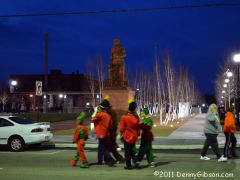
The statue is now in downtown Springfield and I never thought of her being lonely but I definitely see your point. I intentionally chose a peopleless and buildingless view and accidentally aroused your concern. I've since posted another photo (here) that shows the scene as parade time approaches and will hopefully ease your minds regarding the old gal's social life. -
From the album: Denny G's Gallery
© © 2011 Denny Gibson
-
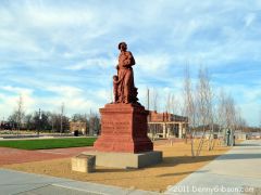
On September 22, Ohio's Madonna of the Trail monument was moved to her third home. The statue originally stood on the grounds of the Masonic Home just west of Springfield. In the 1950s, road construction forced her to move a half mile to the east. Her latest move was another couple of miles to the east to a new National Road Commons park in downtown Springfield. One negative of the move is that the location specific inscriptions on the statue's base are no longer quite accurate. Most consider this a fair trade for gaining easy and safe access to the monument. Visiting it at its former location meant either parking or walking on the shoulder of a sometimes very busy highway. I've placed a picture of the lady's new home in the gallery here.
-
From the album: Denny G's Gallery
© © 2011 Denny Gibson
-
The Long Ride - 23 States In 22 Days In A '51 Hudson
DennyG replied to Alex Burr - hester_nec's topic in General Discussion
I just got a note from Charley pointing out an error in the address posted in my review. I got that as a copy & paste so the same correction is required here. The correct Unit number is 15549 not 14459. Corrected address: Charles B. Woodruff DoDDS-K, Unit 15549 Box 141 APO AP 96205 -
The Long Ride - 23 States In 22 Days In A '51 Hudson
DennyG replied to Alex Burr - hester_nec's topic in General Discussion
Got it, read it, liked it, and say so here. -
I'm Baaacck, W/open Heart Surgery "reasons"
DennyG replied to knightfan26917's topic in General Discussion
You've missed a little and been missed a lot. Welcome back and congrats on the successful operation. -
Things are on schedule for an April opening in the new location with January 7 to be the last day of operation at the old place. With the exception of the 24th (Christmas Eve) the museum will be open every Saturday between now and January 7. http://www.signmuseum.org/visit.asp I lifted the following from the Sign Museum newsletter but I don't think Tod will mind me sharing it: