


mobilene
-
Posts
1,247 -
Joined
-
Last visited
-
Days Won
1
Content Type
Profiles
Forums
Gallery
Blogs
Calendar
Posts posted by mobilene
-
-
:-(
I know the bridge was too narrow, but I'm sad to see it go anyway.
-
Dave, you are a master of Google. I bebopped through the street view of Brazil but did not find these buildings. Not terribly surprising; Brazil is full of holes where buildings used to be. -Jim
-
Dave,
This sleuthing is fun...right up until it's not. 1925 and later sure is late to be laying brick roads! Indiana was busy concreting its section of the National Road by this time. At any rate, this 1925 (or later) date doesn't jibe with the Illinois road maps I found, which show the road as hard surfaced in 1924.
At some point it's time to shrug the shoulders. I'm saying ca 1925 for these photos now and will remain open to more evidence that gives me a more precise date. This in no way diminishes the joy of this find, though!!
As for the tractor being a Sixty, if you blow the photo up to full size (click it; it will take you to Flickr where you can do that), you can see part of the SIXTY logo down the side of the radiator.
-Jim
-
A wrinkle:
http://en.wikipedia.org/wiki/Caterpillar_Sixty
This says that the Caterpillar Sixty was actually designed and built by C.L. Best, the company Holt merged with to form Caterpillar, starting in 1919. If Caterpillar was a Holt brand, would there be Sixtys with the Caterpillar name on them before the merger in 1925?
-Jim
-
Dave, I defer to your superior knowledge of Caterpillars! Clearly my 15 minutes sleuthing the Internet led me to some false conclusions. I didn't know that Caterpillar was a brand name before the company came into existence. Ok, I back this right on up to ca 1920 then. The cars in that one shot are hard to distinguish but all of them have styling consistent with 1920. -Jim
-
Dave,
The Caterpillar is a Caterpillar Sixty. Here's a photo of one. http://www.flickr.com/photos/thumpr455/5599054373/ You can juuuuuuuust make out the SIXTY on the side of the Cat's big radiator in my old photo.
Apparently the Caterpillar company was not formed until 1925, when a merger between Holt and the C.L. Best Gas Tractor Co. So this photo has to be from 1925 or later, because otherwise this tractor would say Best on it, not Caterpillar. The Sixty was a Best design. The Sixty was made until 1931, per Wikipedia.
So I'm surprised. There must have been an interim surface for the National Road laid down in 1920. I'd bet on gravel. And then in or after 1925, the brick was laid.
The eBay auction is here: http://www.ebay.com/itm/151077519888?ssPageName=STRK:MEWNX:IT&_trksid=p3984.m1439.l2649 (while it lasts). In it the seller says these are from the 1930s. I'm not so sure. My gut tells me late 1920s now.
The anecdotes I've heard suggest that Illinois launched a comprehensive state-road-building program in the 1920s and it put what Indiana was doing to shame. The Terre Haute to St. Louis path of the National Road (though 1800s construction stopped in Vandalia, it had been surveyed to STL, and I'm under the impression that local communities may have built the rest of it or at least blazed the trails) was important and would likely have been among the first built under whatever IDOT was called back then.
The National Road was State Route 11 before it became US 40.
And holy frijoles, as I was looking stuff up just now I found a cache of historic IL state road maps! http://www.idaillinois.org/cdm/search/collection/isl9
The 1921 map shows the NR as being mostly dirt with some "hard" sections. The 1922 map removes surface descriptions, daggone it. There's no 1923. The 1924 says the road is hard surfaced.
Soooooooooooooo this makes it all as clear as mud. The Caterpillar tractor can be no older than 1925, but the 1924 map claims a hard surface. I'm going to call these photos "ca. 1925" and move on. Close enough for me for now!!
Thank you so much for your help with this Dave. You are a treasure!
-Jim
-
It's probably safe to guess that it was the brick/concrete. Seems unlikely there'd be a graveling or something only to turn around and do brick/concrete a few years later.
There was no mention in the 1920 ABB's what material was to be used in the construction in the "coming season." -
Awesome! Thanks Dave! It's great to know when this was done. Illinois hard-surfaced its NR before Indiana, then. Indiana didn't start hard surfacing its NR until no earlier than 1922, according to past research I've done with the road guides.
Look at all the manual labor to just lay the road surface down, let alone any leveling and grading necessary to prepare the ground.
The 1920 ABB says that the greater part of this route will be under construction in the "coming season." The road in the 1920 ABB is described as it was described in the 1917 ABB, so I would surmise that between 1917 and 1920 the road was gravel, and dirt, with short stretches of concrete (as described in 1917 ABB). Then it was significantly upgraded in the summer and fall of 1920 -
The Terre Haute to St. Louis route that follows the National Road. Or any route that passes through Marshall, IL, on the National Road, really. Just trying to look for whatever clues they might give about when the road was bricked/concreted. It's brick from the state line through Marshall to about Martinsville, where it becomes concrete to Effingham. What do your guides say about the roads through there?
-Jim
-
Dave,
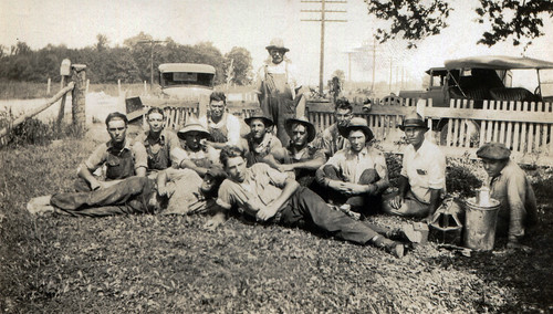
In 2007 while exploring this road I met a woman who lived on it. She remembered a neighbor who had passed a few years before who was on the crew that built this road. Wonder if he's in these photos? Anyway, I'm 90% sure she said 1923, though 10% of me says she said 1917. At any rate, memories are faulty and this is third hand info.
My 1916 ABB says the road is dirt but for occasional concrete stretches. My 1924 ABB says "pavement practically all the way." My Mohawk-Hobbs guides are all from 1924 or after and are no additional help. I wish I had a 1918 and a 1920-21 ABB.
This site is about 2 hours away, so something I'd have to plan.
-Jim
ps. On second look at the photo of the road with my buddy in it, look at the dark debris around the bricks. Tar remnants?
-
Denny -- I'm a little jealous of your trip! Sounds like you had a great time.
-
Do you all remember a few years ago when I explored the abandoned brick and concrete National Road across a large portion of Illinois? Some of it is in good shape:
 Abandoned National Road by mobilene, on FlickrSome of it isn't:
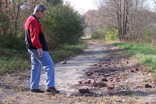 Abandoned National Road by mobilene, on FlickrWell, I just won on eBay a set of seven little photographs showing this brick road being built. I am guessing this happened in the late 1910s or early 1920s. Here they all are, in an order that tells the story of the construction.
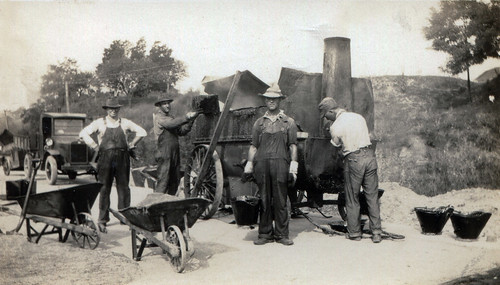 Building the Illinois National Road by mobilene, on Flickr
Look at the tar they're spreading onto the concrete pad on which the bricks sit. Everywhere I explored the road where the bricks are coming up, there is no evidence of this tar. Makes you think the tar was part of what held the bricks in, and when it eroded away, the bricks became loose.
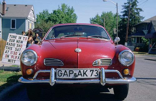
In the photo below, the sign hiding partially behind the Caterpillar mentions that Brazil, IN, is 32 miles away. That places this construction at about Marshall, IL.
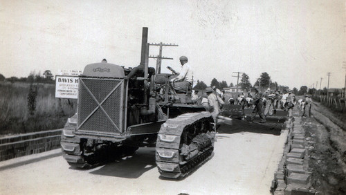 Building the Illinois National Road by mobilene, on Flickr
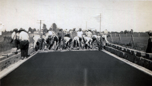 Building the Illinois National Road by mobilene, on Flickr
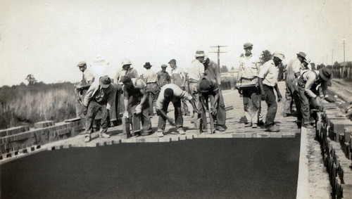 Building the Illinois National Road by mobilene, on FlickrHere's the crew coating the laid bricks with something.
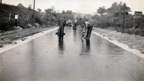
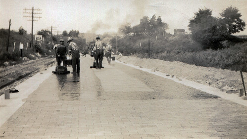 Building the Illinois National Road by mobilene, on FlickrCoating complete.
 -
Eh, roads get extended and truncated all the time. Apparently it can keep happening after the road officially ceases to exist. -Jim
-
Here are the last four posts from our Route 66 trip!!
http://blog.jimgrey.net/2013/04/29/restored-phillips-66-service-station-on-route-66/
http://blog.jimgrey.net/2013/05/01/carspotting-route-66-edition/
-
Ah the "dangerous" stuff we used to do as a matter of course that nobody would dream of today.
-
Excellent sleuthing, Dave! You oughta write a book. -Jim
-
How cool. I never knew about the ball-style fountain head. I do, however, remember my mother warning me never to let my lips touch the fountain. I never could figure out why -- the fountains usually shot the water up so high you wouldn't need to get your lips near the metal. Which, it turns out, was the point of this design.
-
Dave, in honor of you adding a photo so we can all put a face with your name, I've updated my photo.
I am so glad you really enjoyed my expired-film post. And I would be disappointed if, given that you are septuagenarian, you did not tell stories. I believe that when you reach 70, the government should give you a certificate entitling you to tell stories to all passersby, granting all the rights and privileges attendant thereunto. Anyway. I've considered the cost of film photography on my blog before, and I believe that it has never been less expensive (relative to inflation) than now.
http://blog.jimgrey.net/2013/03/11/film-photography-has-never-been-less-expensive/
Unfortunately, since I wrote that post, the CVS near my house took out its one-hour color lab. Goodbye, dirt cheap and super fast processing. I will miss you.
Anyway, yes, by 195x standards ASA 125 was screaming fast. Fortunately, Verichrome Pan was famous for extremely wide latitude -- in other words, you could get the exposure quite wrong and VP would still return a decent image. Films like Kodachrome had very narrow latitude -- you'd better get exposure just right or your image would be ruined. This is why VP was arguably the most popular b/w film in the world for 40 years -- you could jam it into any kind of camera and you'd get snapshots worthy of the family album.
This is why I expected that I'd get overexposed shots from the Brownie Hawkeye when I shot the Kodak Gold 200 -- it's way too fast for the camera and its exposure latitude, while certainly wider than any slide film, is assuredly narrower than good old VP.
Kodak appears to be getting out of the slide film business. I keep meaning to buy some E100G (a version of Ektachrome) to put in the fridge for my old cameras. But I keep shooting Fujicolor 200 negative film because it's so darned inexpensive and I can get it at Meijer (kind of a slightly upscale Wal-Mart we have here in the Midwest). When I was a boy, I eyed non-Kodak films suspiciously. Today, I embrace them -- not only because the Fuji films are generally very good, but because they are often more available than the corresponding Kodak films.
Dig these crazy awesome colors I get from E100G -- it's a shame it's out of production.
Karmann-Ghia by mobilene, on FlickrYour camera stash of yore sounds perfect, especially the TLR and the Yashica rangefinder. I have a very soft spot in my heart for old rangefinders; they form the core of my collection. I must admit, though, that for everyday film shooting I use a K-mount Pentax SLR. You can't go wrong with old Pentax glass.Oh my, I see that I've hijacked my old thread. So I will circle back and say that as I wrote about John's Modern Cabins, you came to mind as I wrote about how the cabins are just right in their current dilapidated condition. It's too bad we can't freeze them in this moment. -
North of Oolitic? Wow, that's out of the way. I wish them luck!
-
And y'all are making me SERIOUSLY want to make some northwestern road trips! You have some delicious old roads up there! -Jim
-
I'll second Dave's motion!
You got some great photos of the old road north of Blgtn. Seems like every time I drive it, there's traffic and I can't figure out how to shake it so I can pull over for pix.
-
Wow, a shot from Polaroid roll film! And such a nice composition. That's awesome! I have a couple rollfilm Polaroid cameras in my collection but the film's been out of production for 30 years.
-
Ooh, I'm digging the Standard station more than the footprints! I personally am glad that the 66 turkey tracks are marked.
This week's crop of posts from the Route:
http://blog.jimgrey.net/2013/04/22/great-bridges-o-route-66/
http://blog.jimgrey.net/2013/04/24/a-kodak-brownie-hawkeye-and-expired-film-on-the-mother-road/
-
Maybe the 1926 routing into which the turkey left his tracks was bypassed after a short time by the current alignment. That would lead to way fewer cars and less of an effect of smoothing out the marks.
What a photo, Dave! Must have been Sunday.
And I had no idea there were nearly 2.5 million cars on the road by 1915.
Building The Illinois National Road
in National Road / U.S. 40
Posted
I posted about this on my blog today: http://blog.jimgrey.net/2013/07/26/building-the-illinois-national-road
A fellow who grew up in Casey, IL, near the road and is now of retirement age commented on this today. He reminded me of an alignment of the NR near Martinsville that was abandoned and is now on private property, after the road was rerouted to cross some railroad tracks at a square angle. He said that the road in there is 9-foot-wide concrete. He further said that west from there strips of the 9-foot concrete are visible, with narrower strips of concrete on either side of it to widen the road to 16 feet. I have a photo of that from 2007: