


mobilene
-
Posts
1,247 -
Joined
-
Last visited
-
Days Won
1
Content Type
Profiles
Forums
Gallery
Blogs
Calendar
Posts posted by mobilene
-
-
Well, it was a safety hazard for overly curious lookie-loos -- I can see someone climbing out there past the barriers, and walking too far onto the deck and having it crumble below him, and then sue the county for damages.
-
 1
1
-
-
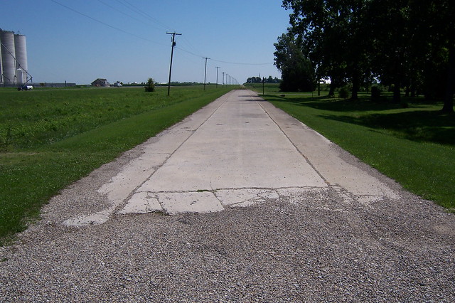
When I surveyed the Michigan Road in 2008, I found this 1903 stone-arch bridge on a one-lane original alignment of the road in southeastern Shelby County, Indiana. This sort of thing is just about the old-road holy grail.
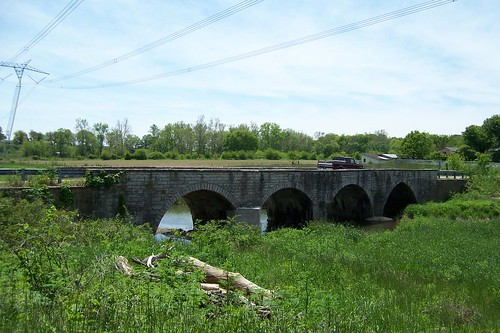 Stone bridge, one-lane alignment by Jim Grey, on Flickr
Unfortunately, in 2013 one of the arches collapsed. Photo by Indiana Landmarks.

To make a long story short, this doomed the bridge. Preservationists tried to save it, but the damage was simply greater than Shelby County could afford to deal with. When I drove by here last week, the bridge had been demolished.
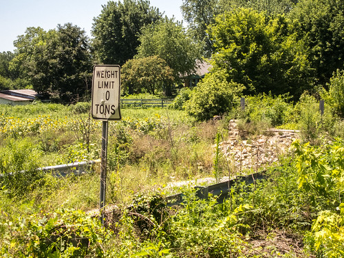 Site of the former Middletown Bridge by Jim Grey, on Flickr
Comedic points go to whoever scratched the "1" off the weight limit sign.
-
I drove back out to that spot and found the cut filled with concrete, so no more exploration is possible. :-(
However, I did enjoy my trip along the Michigan Road in Marion (Indianapolis) and Shelby Counties to review sign placement. Indianapolis Dept. of Public Works and INDOT did great jobs placing the signs. Shelby County screwed it up pretty bad, placing only two of the four signs we asked for, and then in entirely the wrong places. Soooooo I'm trying to get in touch with someone in Shelby County to get it fixed.
-
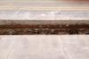
Unfortunately, this is the only photo I got. I was stopped at a light and snapped a quick one with my phone. I was on my way to a job interview -- I lost my job in June and spent most of this summer looking. I start a new job on Monday. But all the networking and interviewing left me little time to hit the road, or to return to this construction site to look more!
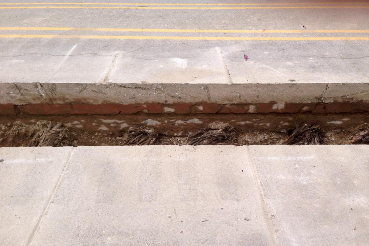
I think the grooving in the concrete is related to the construction, and was not a normal feature of the road.
I wish I had access to info about this road's pavement history. I wonder the same: what the heck IS that beneath the bricks? I know that in some places bricks were laid on a concrete pad, and in others they were laid in sand. That stuff looks like neither. It makes me wonder if it's an older form of pavement that predated the bricks.
I've decided tomorrow is the day to survey the Michigan Road signs in Shelby and Marion Counties. There was an old stone bridge on an 1-lane alignment of the MR in Shelby County that collapsed and has been removed, so I want to see the hole where it was. And I'm interested to see what's changed on that section of the road, as I haven't driven it in a while.
-
I was driving along Washington St. (NR, US 40) in Indianapolis recently and came upon some road construction downtown. Some of the road had been cut out in the middle, and it revealed several layers of pavement. One of them was brick, which isn't terribly surprising as newer surfaces are commonly laid down directly over old. But it was nice to see it. I can't entirely tell what layers lurk below, but I do see splintered wood.
Weather and schedule have prevented me from getting onto the road this season, but I want to drive the Michigan Road in Shelby and Marion Counties to make sure the Historic Michigan Road signs are properly placed, and I want to drive the Lafayette Road, an 1830s road connecting Indianapolis and Lafayette. It was four laned in the early 1930s but a couple two-lane concrete bits remain.
-Jim
-
Great photos! Thanks for sharing.
-
I thought you might enjoy this article at an old-car site for which I write. One of the other contributors got out a box of road-trip photographs his grandfather took going back as far as about 1920 and told some of the stories. All of these photos are from California at that time, and frequently the author includes a link to Google Street View showing the same scene today.
-Jim
-
1
-
-
Got to take a trip on the Lincoln in northestern Indiana not long ago - the 1913 alignment. I've wanted to see the brick segment near Ligonier for approximately forever and I finally got my chance.
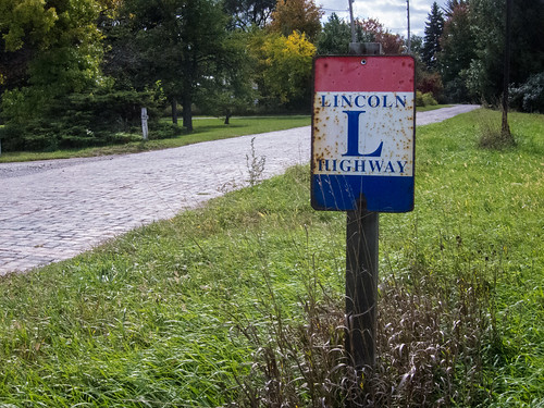 Brick Lincoln Highway by Jim Grey, on Flickr
You come upon it suddenly. We missed the south entrance as we headed northbound, so we turned in on the north entrance.
 Brick Lincoln Highway by Jim Grey, on Flickr
I'm not used to seeing mortared brick roads out here. Most of the ones I've encountered in IN and IL are laid without mortar on a concrete pad.
 Brick Lincoln Highway by Jim Grey, on Flickr
I'm also very impressed with the way this curve was constructed. I've not seen another like it.
 Brick Lincoln Highway by Jim Grey, on Flickr
I've also never seen a brick gutter before. Even on the NR in IL, the gutters are concrete.
 Brick Lincoln Highway by Jim Grey, on Flickr
Here's the south end. That's my girlfriend Margaret over there, exploring on her own.
I've got to do a proper LH tour across Indiana. As we drove between Churubusco and Elkhart I saw all sorts of little road remnants off to the side.
-Jim
-
I think Posey County's ability to manage this is tenuous. But yes, at least something is going to happen.
As much as I love an old bridge, I think it's more important to have a bridge here than a historic bridge, and so if it is most cost effective to raze and rebuild, I'm for it. My understanding is that sometimes you can get federal funds for a rebuild that are not available for a rehab.
-Jim
-
I got to drive that bridge back in '07. My sons and I were on spring break and just drove around as much of Indiana as we could. We didn't particularly want to go into Illinois for anything but I couldn't pass up the opportunity to drive that bridge. So glad I did now.
-
You scofflaw.
I had no idea about this route. I've driven portions of it, esp. IN SR 62, which is one of my favorite drives in the state.
And I've GOT to go see the Triple Whipple one day.
-Jim
-
I forgot my password and so went through the Forgot Password process.
This process uses a "key captcha" to validate that I'm a human. I was asked to sort pictures by dragging them into groups. The problem was, the pictures were too small for me to make out. I failed this process six times before finally succeeding.
It was a massive pain.
Can this be eliminated or changed to something more doable?
-
This is perfect Dave! I found that resource on Google Books. I keep forgetting to search there. Such a valuable resource.
I also found there some Illinois Dept of Highways reports from the early 20s. The photos in those are fascinating. There's one photo there of a crew widening a 10-foot road to allow 2 lanes of traffic. So clearly Illinois build these narrow roads in several places. There are no references to a 9-foot-wide concrete road, so perhaps this segment I've photographed is actually 10 feet wide. I didn't exactly get down and measure it!
What is clear from these DOH reports is that Illinois was road-building crazy in the early 1920s!
Interesting to me that the 1922 ABB says concrete all the way when between the state line and about Clark Center the road was paved in brick. But whatevs -- it was still a hard surface.
-
P.S. A commenter on my blog left this comment:
One other clue to dating of this section. George Stewart says he travelled this section of the National Road in 1919 after WW1 and while Indiana’s road was paved the bottom just totally dropped out at the Illinois line. Also since the old road has continued in use from the west side of Casey( where I grew up) to a couple of miles east of Martinsville the original bridges were still in use when I started driving. The date plates had them built in 1920. It was interesting on the old 16 foot wide pavement to meet the daily Greyhound bus on that road. Just east of Martinsville old 40 makes a swing to the north and goes under the PA RR. East of this you can see where the original National road went straight west towards Martinsville and had a 9 foot wide concrete slab. East of where old 40 rejoins “new”40 you can see that they added concrete strips on either side of the 9 foot strip for several miles to widen it to probably 16 foot wide. It’s funny that around 1955 “new “40 was completed and they still call it that… But then in Casey the high school gym was built in 1927 and is still referred to as the “new” gym.
-
It seems clear to me that this road segment was left behind because they wanted to eliminate that awkward (and therefore probably very dangerous) grade crossing. The "new" road curves around and actually runs under the tracks (grade separation).
I had a conversation with a lady who lives on the road in Illinois who knew someone who laid bricks on the brick section to the east of here, and I believe she told me that the bricks went down in "about 1920." My guess is that the 9-foot concrete is contemporary to the bricks.
I do not know whether Illinois's IDOT predecessor produced an annual report.
Here's a cache of historic Illinois road maps: http://www.idaillinois.org/cdm/search/collection/isl9. The 1921 map shows the NR as "dirt" all the way. The 1922 map does not distinguish road surface types, unfortunately. The 1924 map shows the road as hard-surfaced all the way. So I believe this narrows it down to 1921-24.
Here, from my 2007 trip down this road, is what Illinois did to make this 9-foot-wide road viable: add two concrete strips along either side for a two-lane road.
 Abandoned National Road by Jim Grey, on Flickr
-Jim
-

I went out on the National Road in Illinois yesterday for the first time since 2007. There were a couple things I wanted to see, including a rumored 9-foot-wide concrete road that is now on private property east of Martinsville. Sure enough, there it was. See the attached photo. If you look on Google Maps in Earth view, you can see it clearly. It's "Farm Ln" on the map. As you can see, the road was rerouted here to cross a railroad track at a safe angle (actually, a grade separation was created) -- and it left this old concrete behind.
Elsewhere on the IL NR, you can find segments of this 9-foot-wide road, but it has been augmented with additional concrete strips on either side to bring the road to (probably) 16 feet wide. The 9-foot-wide section clearly didn't work out all that well.
I would love to know when this 9-foot-wide concrete was poured.
-
I'm unlikely to find time to make a trip to Richmond before the project is done. My life is simply too busy, unfortunately. :-(
-
A road improvement project uncovered this 1832 stone-arch culvert in Richmond, Indiana.
-
Well poop. There was no reason at all for any heavy traffic to use that bridge, when the next alignment of the road passed right next to it.
-
I spent 3 days exploring Ohio's NR and could have spent 5. Indiana's NR is most interesting west of Indianapolis -- one abandoned bridge and a few old alignments lurk.
-
Great photos. Ohio's NR is a fabulous trip, especially in eastern Ohio.
-
-
Nice find. I've not noticed the use of REALLY short bricks (such as at lower middle of your closeup) on other roads but I'm going to start looking.
Good eye. Those are probably cut so that the bricks fit the roadway width. I wonder why they put them one in from the edge, rather than at the edge.
-
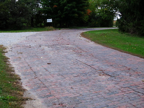
It's well known that when the Dixie Highway was organized, Martinsville, Indiana, welcomed it heartily. There was a brickmaking industry there, and so the town laid bricks along a couple miles of the Dixie Highway through its town, in 1915.
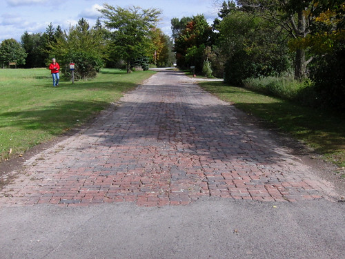
The brick Dixie is long gone; the best we can hope for is that those bricks lurk beneath layers of asphalt. But I did find a section of brick road that would have been the first alignment of what (later) became State Road 39 on Martinsville's northwest side, near where it crosses the west fork of the White River. Here's the road more or less south/west-bound.
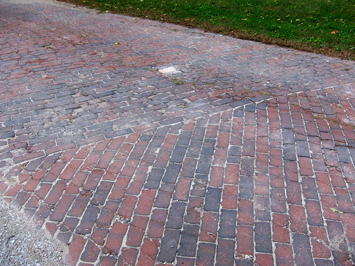
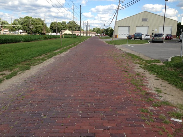 Old brick road by mobilene, on FlickrHere's a detail photo of a concrete curb. Based on materials I found searching "brick Dixie Highway Martinsville" on Google, I gather that a concrete base was laid featuring these curbs, a layer of sand went in next, and then these bricks.
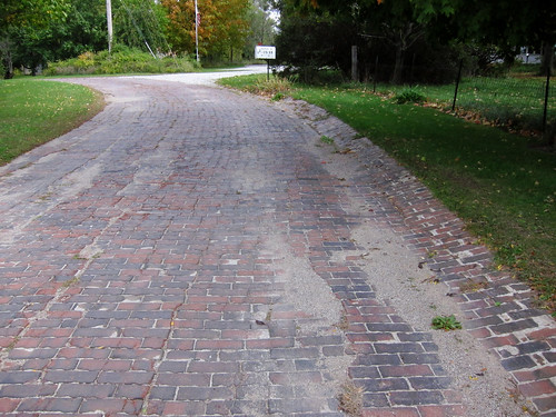
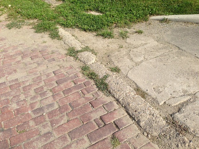 Old brick road by mobilene, on FlickrHere's the old brick road as it fades away. If you squint, you can see the modern (and new, in the past couple years) SR 39 bridge back there in the distance. If you look at Google Maps aerial views, it shows this bridge under construction with the old bridge still in place and more of this brick road evident. It appears that the bridge construction removed or buried the bricks closer to the river.
I have no real way of knowing right now when these bricks were laid, but it's not unreasonable to guess about 1915 if Martinsville was busy laying bricks on the Dixie at that time.

Abbs On The Internet Archive
in General Discussion
Posted
Someone has scanned and uploaded a whole passel of Automobile Blue Books at the Internet Archive. The link:
https://archive.org/details/newberry?sort=-publicdate&and%5B0%5D=blue+automobile
-Jim