


cityboy1986
-
Posts
56 -
Joined
-
Last visited
Content Type
Profiles
Forums
Gallery
Blogs
Calendar
Posts posted by cityboy1986
-
-
Hi Tracy,
Thanks so much for taking a moment to provide us with your feedback. Regarding year of birth - that question may give us insight into whether or not American Road appeals to a particular age group or if it appeals to all age groups. From there we determine if we are meeting our goals, or if we need to make adjustments in order to do so.
Thanks again for providing us with input.
Best,
Becky
I figured that's why you were asking. I was merely commenting that I had to age myself by four years because 1986 was not an option for year of birth.
The team did great work on the last issue, by the way!
Happy to provide feedback,
Tracy
-
I did mine as well, but I had to put my date of birth in 1982. What's the big difference besides insurance cost anyway <grin>?
Tracy
-
Thanks for posting this! Mississippi has very few remnants of roads from this era. Most of the brick and concrete roads have a few layers of pavement on top of them. The major exception to this is the Delta, where highways are still regularly paved with concrete. During my first year of college, U.S. 11 between Lumberton and Poplarville was still concrete, but it was paved over with asphault.
Some concrete roads can be found in other areas of the state; I know of two sections west of Meridian on old U.S. 80. Dirt and gravel roads are still common (thankfully, not for highways); one near here with several 90 degree turns has an exit on the expressway!
Many paved country roads in this state still do not have lines, centre or otherwise. Until 911 and the naming of roads in the rural areas, some didn't even have stop signs, only gaining one when a road designation sign was placed on a stop sign.
Dig the stop sign at 5:40.
Tracy
-
Mobilene,
My comparison of Ind. and Miss. was due to relative flatness and mostly-straight roads. Part of this could be because many of the highways in this part of the state are newer, built over areas that were farmland.
I think the opening notes of the WBBM theme are the cause of my favouring it. To me, that theme just screams, "News!" I also like the pre-'95 ABC Information Radio and "Move Closer to Your World."
Keep,
Now I don't feel so bad for taking pictures of street scenes and such. Even in the short time I've been driving and photographing (about five years), some of the things have changed. I have to admit to taking photos of sunsets, rivers and the like as well, though.
Tracy
-
Mobilene,
Thanks for posting the videos that remind me very much of my "adopted" home (at least during my stay at college) in northeastern Miss. I thought I recognised the whistling, as that theme is one of my favourites, but I thought, "Nah, that couldn't be it." Funny how people with similar interests share other interests.
Keep,
I must be a movie junkie, as I watched both of them. And yes, I listened to the sounds of the projector in both shots </geek>. I wouldn't be surprised if everyone still meets under that tree! Small towns can be resistant to change.
I enjoyed the look at Virginia City as well. It was fun to count the number of Fords in that video just by looking at the taillights. Thanks for posting these from a time when neither of my parents had started grammar school!
Tracy
-
Add me to the people who got five right. I missed the ones about the bridge that carries the highest number (in my defense, everyone I know calls it the Luling Bridge) and the number named after members of the House of Representatives. I definitely don't pay attention to the names of bridges.
Tracy
-
Alex,
I'm glad to have brought back some memories. Being in Starkville, Miss., most of the month, if I want to head west I almost have no choice except to go through Winona. After the ~sixty miles on four-lane U.S. 82, I always welcome the chance to go through downtown Winona. Like most places have, I'm sure it has changed in (almost) fifty years.
Keep,
I appreciate your keeping Zoomify for the format, but I would have no objection to your using PDF files if those aren't as big.
I have the 1926 ABB, which is mainly focused on turn-by-turn directions, so the maps from the 1927 edition are welcomed! I was very fortunate to get an ABB that came with a map and the holder (which added $1.00 to the $3.00 cost of the book!), but since the map covers most of the East Coast, the level of detail is very low.
It's interesting to see how many towns (or, probably more correctly, villages) were recognised then in places that are just open country today. For instance, in the Vol. 4 Sec. 35 map near my house, there are five named places between the Lamar county line and Lumberton on what is today Miss. Hwy. 13; today, Baxterville is the only one that is noteworthy. The only remainders of many of those villages are the names of the roads (i.e. Wells Road north of Lumberton).
Thanks again,
Tracy
-
Zoomify does work well, even on dial-up (ah, to live in a place where that is the only service available).
There is a 1926 Rand McNally map at the Broer Map Library, but it is nice to see how other maps were drawn. There were always the inconsistencies between mapmakers regarding road completion, too.
Thanks for sharing,
Tracy
-
We finally see the beginning of the journey!
Once again I wish I could take a trip through that area. Someday..
Old U.S. 40 looks like it still gets some use, at least compared to the lesser-used roads around here, which have grass growing in the centreline.
Now to reread your entire series of posts from this trip.
Tracy
-
Keep,
You're right about that. Even eating takes money (well, most of the time <grin>).
I never have taken an Economics class, since I changed my major from business the semester before I would have taken one. Yes, I'm in the "I've changed my major at least twice group". With History, I have to write a twenty-five page paper for my BA, but at least I can write about a topic I like! I just hope the professor doesn't mind reading twenty-five pages of road talk.
My great-great grandfather did not fight in the Civil War; instead, he hid in the Honey Island Swamp between La. and Miss. Maybe that's a good thing, though, since my great grandfather was born in 1864.
Will try to keep more in touch than I have,
Tracy
-
Thanks for the photos! I had a dream once where models were lined up by year as opposed to just thrown together. I never knew that setup actually existed!
The older road memorabilia is nice to look at as well. Texaco is certainly well-represented!
My hometown used to host a small auto show once a year. It was fun seeing the cars, but even then I didn't care for the heavily modified ones that always seem to pop up. From the pictures you've shown, the LeMay collection doesn't seem to have those.
Tracy
-
Hi,
I think the newer cutouts were meant for overhead guide signage on interstates/freeways. There are a few more around the country (I know there are a couple on U.S. 33 in Columbus, Ohio). Nevertheless, great find!
I'm also of the mindset that thinks the cutouts look better. All needed is a glance at my picture to tell that!
This link leads to a nice page of the highway signs through the years, broken down by state. Having grown up in a world where all the U.S. Highway signs are black and white, it's hard to imagine a time when you could tell which state you were in just by looking at the highway shield.
Tracy
-
Jeff,
I'm glad you enjoyed the photos. Since I was carrying a 1957 road atlas, I knew the general routings of the old U.S. routes through Dallas and the rest of the state. I had a general idea of the older autoroutes, but I didn't know their exact routings.
Would you rather I leave the imperfections (like the crack in the windshield) in the pictures, or should I do my best to make them blend in with the rest of the pictures? My editing skills aren't the best, but I can at least try to make the crack less glaring. As always, I wish I had taken more and better pictures. Hindsight really is 20/20 or maybe 20/15.
Like Keep, I have seen your site before. U.S. 80 is one of my dream drives (I'm sure some here are wondering if any road isn't one of my dream drives); I'm only familiar with it in Mississippi and Alabama (somewhat--I went between Meridian, Miss., and Montgomery sometime between midnight and sunrise!). I've tried to make something similar to the U.S. 80 driving guide for U.S. 11.
Keep,
Thanks for your well-wishing. Amazing how classes and the work required take all the fun out of college <g>!
Sitting two miles from beautiful downtown Starkville, Mississippi, </announcer voice>
Tracy
-
Thanks for posting this! The steel truss bridge is really something.
Are those two old pumps at the Texaco station actually functional?
jim
I don't think they are. There is a curb to the right of the pumps, where the cars are parked.
Tracy
-
Cityboy1986,
Thanks for the bonus shots! Now I have been across Lake Ponchartrain. That is one big pond!!
And Dallas doesn't look like it was deserted after all.
Any other road trips coming up?
Keep the Show on the Road!
Yes, Lake Pontchartrain can be scary if one is afraid of long bridges. I do have to drive to university sometime within the next two weeks. I hope to leave early enough in the day to take my time getting up there, so I can get some pictures.
BTW, if you decide to view the full list of bridges in Texas, make sure you have some time to spare, especially if you're on dialup! I might just let it load overnight and save it <g>.
G'day and take care,
Tracy
-
Hi,
Thanks for the replies!
Keep,
Dallas looked shut down. Were these taken very early or late, .....or what explains the absence of cars?The Dallas pictures were taken at around 7:30 p.m. Downtown was somewhat busy, but it didn't become busy again until I got on the interstate at Illinois Avenue.
I cranked up the old map software to mark your route....you sure did detour!! How did you decide the route you took?I've traveled I-35 between Dallas and Austin often, so I decided to see what I'd missed on the old highway. That is why I took U.S. 90 in the southern part of the state as well.
I like the small towns. You don’t see many Western Auto store signs anymore, not like once. And that has got to be an old Texaco sign. It looks like the ones I knew as a kid. I have seen a few restored in the last few years, but not one that is “virgin,” as yours appears.For the full version of that picture, see this link. For the full versions of the rest of the pictures (and more), see this page.
Thanks for the links to bridge sites! As you can probably tell, old bridges are interesting to me. Unfortunately, the listing of all bridges doesn't include the bridges that Mississippi has bypassed, but it is a great, useful site.
Alex, is the widening of 51 between Southaven and Hernando (just south of Memphis)? If so, I think they are getting themselves ready for any population increase in that area. I agree that it is a waste, however. 55 is at most a mile away!
I have a Geocities web site at which I have posted a few road pictures, all of which have been featured on this site (if I recall correctly). The link is here.
G'day and take care,
Tracy
-
Hi,
I feel as if I've taken the trip with you! I have been through that section of Oregon, but my dad chose to stick with the Interstate (it probably helped that we were in an eighteen-wheeler).
Thanks for providing a then and now picture of Ontario. I wonder if the citizens of Ontario in 1926 dreamed of buying radios in their town, much less televisions, computers, etc., at Radio Shack.
Sadly, there are probably some in this world who would still prefer to see signs reading "All white help." That burger brought up my spirits, however (not to mention my appetite).
Looking forward to more,
Tracy
-
Hi,
Thanks for showcasing U.S. 51 (old and new)! I have experience with the southern part of the route; I have traveled between La Place, La., and Batesville, Miss.
I always enjoy finding which set of lanes on four-lane routes is the old set. Even better, of course, is finding bypassed segments!
Looking forward to more,
Tracy
-
Hi, all,
Last week, I had to take my dad from Mississippi to Rockwall, Tex. (about thirty miles east of Dallas). Being a fan of the older roads and having an appetite for long trips, I decided to only go 500 miles out of my way, by way of Austin. I didn't get as many pictures as I would have liked, and only some of those pictures were passable, but here they are:
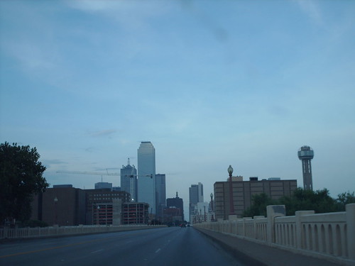
Dallas skyline from the Commerce Street Bridge over the Trinity River.
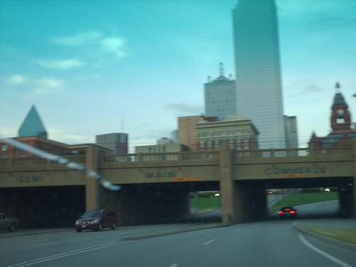
The Commerce Street Viaduct in Dallas. Of course, my camera decided to focus on the car in the foreground.
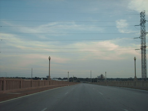
The Houston Street Bridge over the Trinity River. Dallas was amazingly empty south of downtown (on the surface streets, anyway).
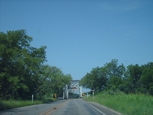
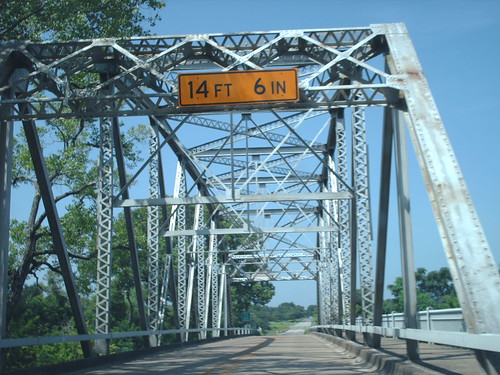
These pictures are near an old truss bridge on Old U.S. 81 between Temple and Belton, Tex.
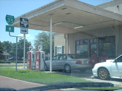
An old Texaco station in Georgetown, Tex. There was a nice Texaco sign that I missed, but..
There was this old one in (I think) Waelder, Tex.
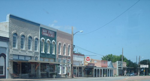
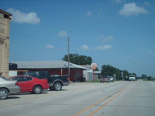
This nice street scene (and vintage Western Auto sign) was in Flatonia, Tex.
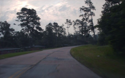
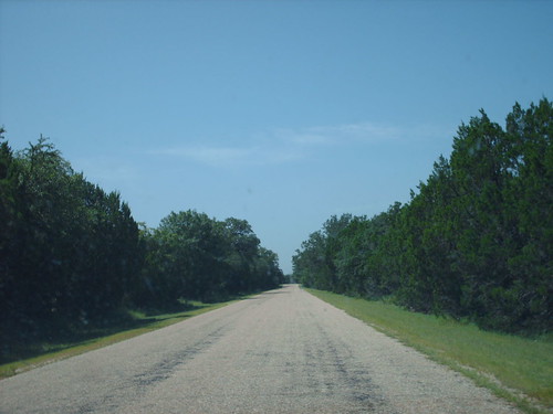
I don't think any old alignment post can be made without a picture of an old alignment. This section of old U.S. 90 is just east of Vidor, Tex.
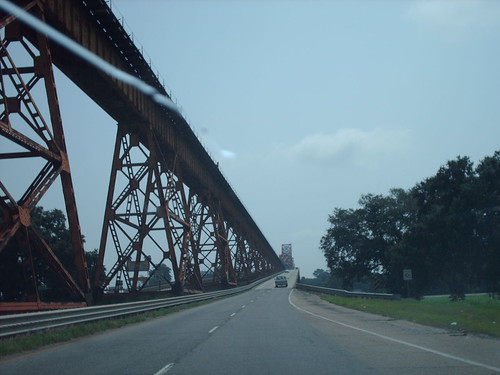
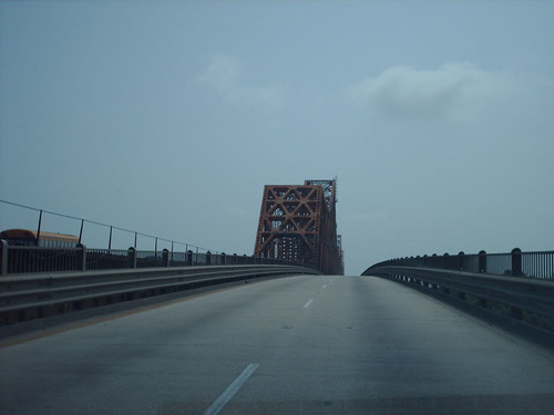
These two are of the western approach to the Huey P. Long Bridge, near Baton Rouge, La. It, of course, goes over the Mississippi River, and it carries U.S. 190.
U.S. 190 also boasts this treasure between Baton Rouge and Denham Springs.
I hope I haven't bored you, and thanks for looking!
Tracy
-
The other one is still using the ferry - so far your in the right area for one of them, but it wasn't that ferry.

Hudsonly,
Alex Burr
U S 80 is NOT one of them.
If nobody figures it out by tomorrow I'll let everybody know.
Hudsonly,
Alex B
I'm pretty sure you're looking for U.S. 9 between Cape May, N.J., and Delaware and U.S. 10 between Ludington, Mich., and Manitowoc, Wisc., both of which are still routed across ferries.
Routing U.S. highways across ferries was, of course, very common during the early years of the system (and somewhat common until the 1950s or 1960s, at least, where a long bridge crossing would have been required, such as U.S. 13 in Va. and U.S. 16 over Lake Michigan). Only until the 1970s (I think) were U.S. 9 and 10 the _only_ U.S. highways that were routed over ferries.
This probably doesn't count, but U.S. 90 between Bay St. Louis and Pass Christian, Miss., had a ferry routing for a time between Hurricane Katrina and the reopening of the new bridge over St. Louis Bay.
-
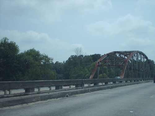
I cannot promise the beautiful scenery of the western U.S., the photographic abilities of the former posters or even a picture of a bridge that served a famous highway.
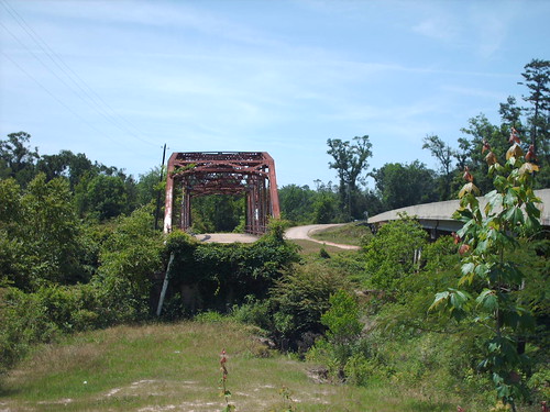
The bridge is located on Old U.S. 49 just south of Brooklyn, Miss. Before 1936, U.S. 49 had a split from Hattiesburg to Brooklyn, and this bridge over Black Creek was just south of the southern end of the split. Since it is a truss bridge, it may go back to before the days of U.S. highways. The 1926 Automobile Blue Book lists this route as the Florida-Midwest Highway (which apparently never went to Florida nor the Midwest, as the ABB shows it only between Gulfport and Jackson, Miss.). James Schul's North American Auto Trails listing for the Jeff Davis Highway (not the Jefferson Davis Highway, but the two shared some roadway, which must have been somewhat confusing) makes that highway seem as if it also took this route.
As seen in the picture, the bridge is unfortunately no longer drivable; Mississippi's way of preserving truss bridges lately (within the past twenty years) has been to build a bypass bridge and remove the roadbed surrounding the bridge.
-
<snipped parts to save bandwidth>
It is tough to get old maps of Mississippi. Apparently it wasn’t a big touring state like say California or New York. Where do you find your maps? Ebay or locally?
I’ve been to Mississippi only once five years ago, but thoroughly enjoyed the two lane roads I traveled. Fascinating small towns dot the countryside, and I would give a bundle right now for some good ribs prepared in the Mississippi manner!
My 90 year old uncle wanted to see where his grandfather had been so we landed at Baton Rouge and worked our way north to Corinth. Of course we stopped in Natchez and followed the Trace for a ways.
I missed so much along the way, I would enjoy getting back one day when I had more time. I don’t think Mississippi gets enough credit for its old roads. Have you posted any trip descriptions or photos. I would enjoy seeing some.
I see you must be near US 11. It looks like a fascinating route. I will have to take a closer look at it. If you do any photographs of the area, please share them if you get a chance.
Back to the maps. I have a 1927 Automobile Blue Book of the “Mid South.” By 1927 they didn’t need the turn by turn directions anymore, and it is more like a modern AAA Tour Book. It does have great photos and descriptions. Unfortunately it is in bad shape.
I bought my Mississippi map on eBay. I must have been searching at the right time since my first search found it. The map's not strictly Mississippi; it also covers Ark. and La., a practice that is continued today in some maps.
I go between college and home every two weeks (about 400 miles roundtrip), so I have plenty of chances to drive the two-lane roads. I've driven every practical route between the two locales, meaning it is time to discover the impractical routes (although some would say that using a two-lane when there's an interstate highway nearby is impractical). I don't have any photos of U.S. 11, but I have some of an abandoned bridge on U.S. 45 that I will share. This summer I hope to take more trips and snap more pictures.
I'm glad I opted for the 1926 version of ABB instead of the 1927! My copy is in surprisingly good shape. The only bad spots are the map holder and the map.
CityBoy1986
-
I don't have a large collection, but I use a few tools that have come in handy whilst exploring old roads.
My oldest is a 1926 Automobile Blue Book, Vol. 2 (Southeast and Mid Atlantic). The road descriptions were still there, but whenever the route followed a state highway, the turn-by-turn directions stopped. Luckily (for me, anyway), Mississippi didn't implement a state highway system until 1931.
My second oldest item is a 1932 Rand McNally map of Mississippi. It's helpful since the ABB map shows almost no roads other than ABB routes. It also shows the subtle (some not so subtle) changes in the state highway system. Also handy are the ten or so city maps.
My most practical for roadtrips (thus, the one I never leave at home) is a 1957 Rand McNally 48 state, Canada and Mexico atlas. There are some four lane and expressway segments shown, but there isn't an Interstate shield to be found.
I have several newer atlases (next-oldest is 1981), but until I'm out of college, I don't have much to spend on collecting maps/travel guides. I spend enough on gasoline as it is <grin>.
CityBoy1986
-
I will never forgive myself for tossing out my outdated maps years ago, before I realized how much history I was throwing into the trash.
 Now trying to replace some of them, I haven't a clue where to begin the hunt. Currently, I'm trying to find 1940s and especially 1950s road maps of California and southern California. Anyone able to help a new searcher?
Dolores
I don't know how you feel about buying things online. I've only managed to use eBay to buy items eight times in two years, and only three of those were road-related (a 1926 Automobile Blue Book, a 1932 map of Mississippi and a 1957 national Rand McNally atlas). I have never had a problem. Just be sure to read the seller's feedback, if there is any. Set a limit on how much you want to spend, and decide if an item is really worth the listed price. With maps of Mississippi being listed nearly every day, I'm sure many more of California are sold. I know people here have much more experience than I do.
If you don't like the idea of purchasing online (and even if you do), unexpected surprises can be found in flea markets, yard sales, etc. An advantage is that you can actually inspect an item for yourself before deciding to purchase it.
I hope this helps, and I hope you can build a new collection.
T. Michael
Road Trip Dreams
in General Discussion
Posted · Edited by cityboy1986
Living in a state with mild winters, my dream in this post is more about convenience than the weather. I want to take a weekend that would be spent in Starkville driving US 45 and 51 to Cairo, Ill., making my way to Sikeston, Mo., and then taking US 61 down to Memphis, returning to Starkville however I see fit at the time. Of course, when I say 45/51/61, I mean following historic alignments as much as possible instead of the four lane monstrosities that 45 and 61 are now in Tenn. and Ark., respectively.
I would like to take a trip like the one I took to Texas during the summer, as well. Of course, there are always small trips around the state (like that one I once took on a whim to Greenville to see the US 82 bridge over the Mississippi).
We have the County Challenge in Miss. as well; I think I've geocached in four out of eighty-four <laugh>.
Tracy