


Keep the Show on the Road!
-
Posts
2,829 -
Joined
-
Last visited
-
Days Won
26
Content Type
Profiles
Forums
Gallery
Blogs
Calendar
Posts posted by Keep the Show on the Road!
-
-
Denny,
Thoughtful post! It looks like Bernie was always a good scout!
Dave
Keep the Show on the Road
-
Rick,
A downright great description!! You're are a great example of the road aware traveler, who makes the most of where he visits. I especially liked the picnic by the pool!! Terrific, and so memorable for you and your family. Your daughter is sure to recall her trip to her college all her life... Making treasured memories to last lifetimes.
The photos are terrific,as yours always are. And I bet you don't make my old mistake and think the mountains or waterfalls will be what you remember. I failed to get enough photos of the family in my photos. I have a basement full of scenic Kodachromes gathering mold, while my old family Polaroids are treasured by all. Old too soon, smart too late

I really appreciate you taking the time to share! I could recall many of the places you mentioned.
I also liked the .transition to college reflections. Not to wax nostalgic, but it is probable that you were driving into a different life for the whole family, leaving behind some great times, and looking forward to more and different adventures, It is terrific that you shared those important moments and didn't just fly to Santa Fe as quickly as possible.
Cheers and best wishes!
Dave
Keep the Show on the Road!
-
Rick,
Thanks for the more detailed description of your experience and the site! With the always great photos, it is practically like being there!
I have been to Santa Fe a couple of times but have yet to visit La Bajada. Sheila likes Santa Fe, so it may still be in my future.....
I suppose you re back home now. How did you come and go.....by what routes?
Dave
Keep the Show on the Road!
-
Rick,
Great shots and description. It is on my bucket list and has been for years! Glad you visited!!
Dave
Keep the Show on the Road!
-
Your post was clear, and I recognized that you were thinking of routes on the west side of the cascades, and much later than the auto trail era. I used your post to identify the only broadly identified Bee Line route in Oregon from the period of the auto trails. It was an alternate to 99 (I know from experience), but obviously not located in the valley.
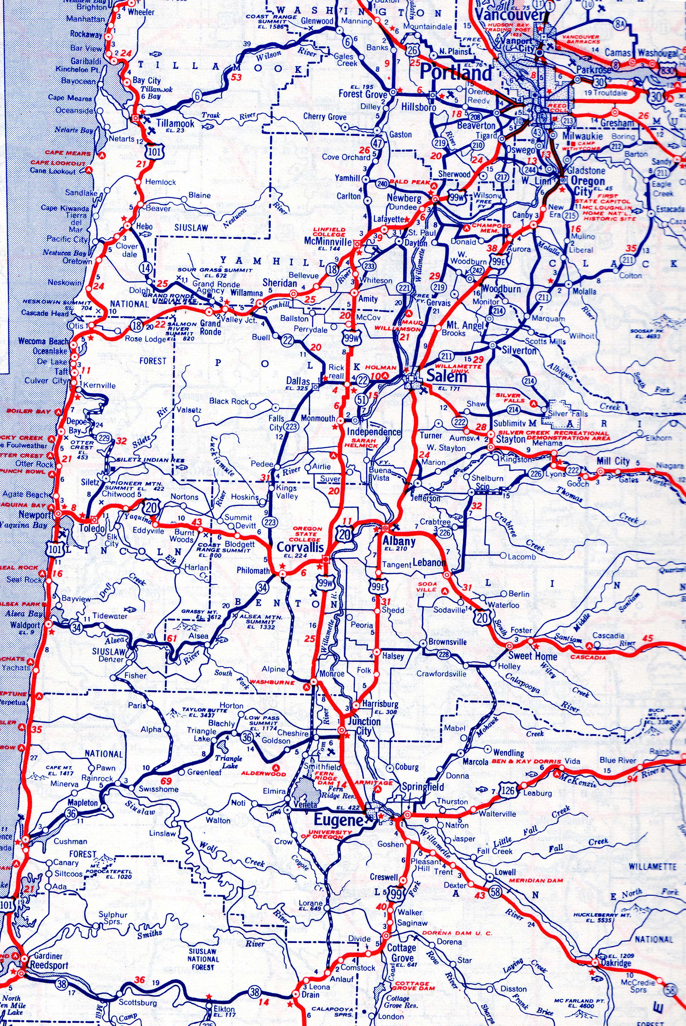
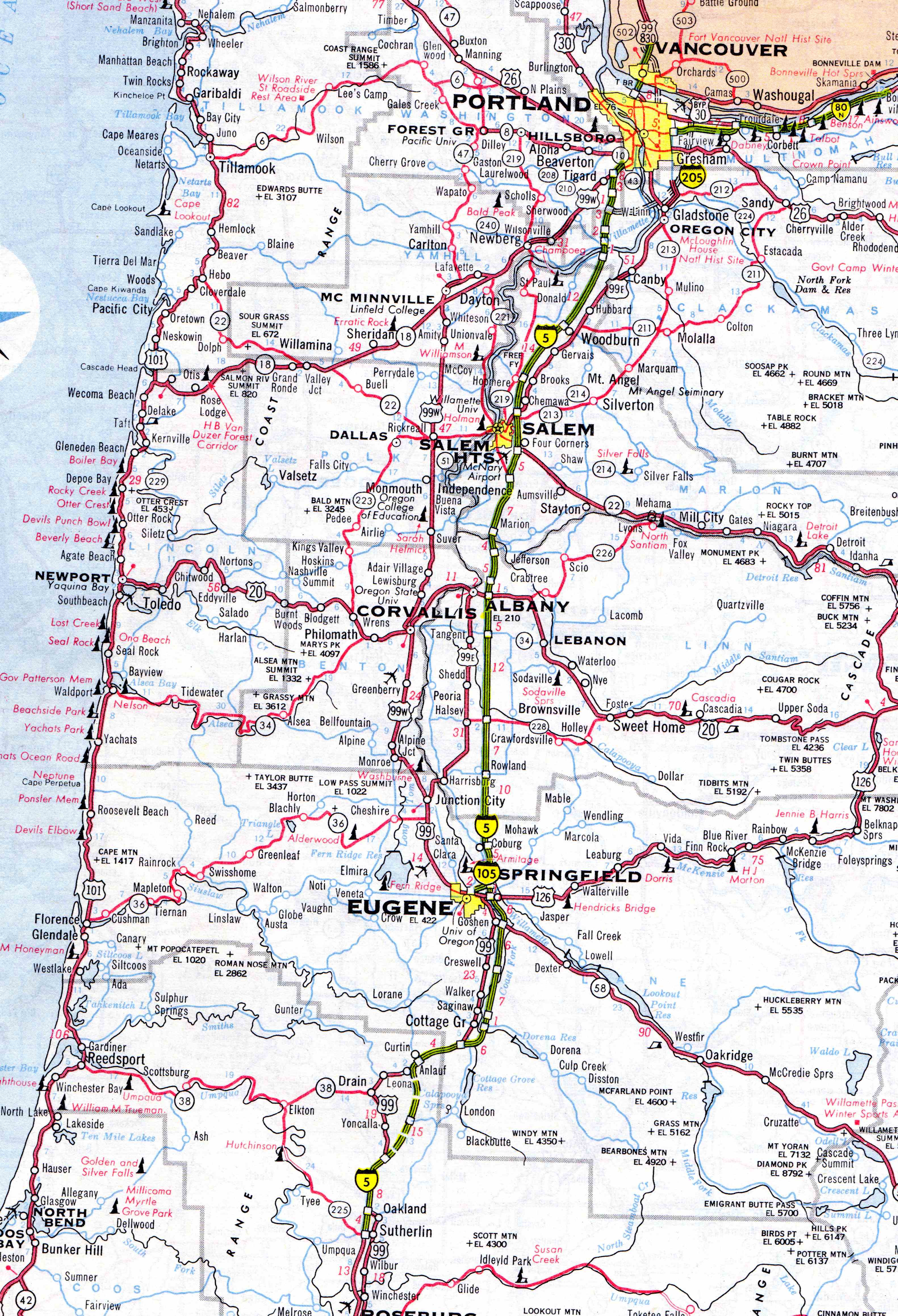
Of course terms like “Beeline,” “Bee Line,” or “B-Line” were frequently applied to roads for obvious reasons. I haven't found any reference to a beeline named road close to US99 in Oregon. However I have posted below Oregon roads maps from 1952 and 1964 (pre and post interstate) and a close inspection will suggest there is a combination of state and county roads that, when taken together, form a route generally parallel to US99, and which broadly conform to your red line.
It certainly is conceivable that enterprising folks in Lebanon Scio, Stayton, and Silverton (etc.) figured they could divert some business their way with a “beeline” designation, posted as you suggest. One can even envision a route all the way from Springfield (northbound, see 1952 map) , bypassing congestion in Eugene and Salem. So far, though, I have not found any direct reference to the route. I think I might jest that if it didn't exist, it should have!!
Perhaps someone will find a brochure, or even a RPPC with the beeline on it. Since almost all my materials precede 1950, I will probably not be the one....but good luck!
Dave
Keep the Show on the Road!
-
 1
1
-
-
fauxsuper,
US 97 via Bend was known as the California Banff Bee Line in auto trail days. Old US 99 (Pacific Highway) was indeed busy and I suppose north south travelers could have used the California Banff Bee Line as an alternative. I know my family did in the 1950's.
The trail blaze was white, blue, white with CB in black.. If you want more info (map, turn by turn directions, let me know!! I can probably go back as far as 100 years. And thanks for your interest and question!!
Dave
Keep the Show on the Road!
-
I hate to see a fellow's pain go unnoticed. Tough times for you indeed!
My personal experience with your issues is very limited, but I have a close relative getting SS disability. As you know it is routinely denied, and there are attorneys who make a handsome living fighting and winning disability claims, for a share of the income. The process sucks, but if you have applied and been denied, their income is earned on a share of the payments you receive back to the date of your application. In short they don't charge fees, they just take a share of the back payments. If you are disabled and have applied and been denied, they will jump at the opportunity to help you get your benefits.
I have no idea the extent to which your serious heart condition limits your ability to work. If you are totally disabled you are almost certainly eligible for disability even if it takes several tries with competent legal assistance. Of course, if you can work full time, and are actively seeking work, it is a tough argument to claim disability.
I don't recall where you live so I don't know the employment outlook. I suppose a move is rational if the prospects where you are are very poor. And obviously the more narrowly you define what you can and will do, the lower the chances of getting a job. I don't see in your posts the actions you are taking to find work where you are. I doubt any of the geographic areas you cite are so much better than where you are that a move is a certain solution....but I wouldn't dismiss it.
Your local community college might be a helpful place to visit. If you don't already have a college degree (or in some cases if you do) you may be eligible for federal grants, student loans, and possibly a retraining program. Even in the worst case, you can probably find a sympathetic counselor who will help you define a plan and locate possible employers. And usually the college works with Worksource or whatever employment program the state supports.
Well, that is a lot more than you asked for. I hope you turn the corner into the sunshine soon!
Dave
-
1
-
-
Tom,
Does it get any better?? An ode to your parents, America, and a fine old car!! And you!!
Keep in touch, and dream another road trip into reality!!
Dave
Keep the Show on the Road!!
-
Cort,
Good to see you back on the boards! I am a bit out of the way here in Washington State for a hookup, but let me know if I can help with some old road descriptions.
Dave
Keep the Show on the Road!
-
Dale,
I count it as your good fortune to have enjoyed it, and ours that you shared it with us. We are both of such tender years as to recognize that things change. We enjoy them, have the privilege of sharing our experiences, and value our great memories. Keep all of us in the loop. Your experiences are appreciated and we get to enjoy them through your eyes!
Dave
-
Dale,
That is not good news, for the International or your wife!
I don't know the owner, but some of those places die with them.Thanks for the updates....I really appreciate them!!
Dave
-
Robert,
I read every word and viewed every photo of your old Kensico site. Nice job, and well worth anyone's time to visit the site. The old foundations were certainly evocative! Your effort should be much appreciated in the future.
I can very vagely enjoy a feeling for the ara as I spent a couple of weeks at White Plains many years ago when I was with IBM. It was winter and I was a California boy....quite an experience.
Thanks for the reflections!!
Dave
-
Dale,
Interesting!! And your post revived my recollection of a dam crossing I did this spring, and it has a fairly good story behind it.
But before I digress, I went looking for your dam on Google Earth. I went to Jackpot but got distracted. There just northeast of Jackpot is Idavada...a "clever" combination of the states' names. But Idavada is just a field, not even a mud hole. I am now the Mayor of Idavada and until I am renounced by authority,, send your donations directly to me for the renovation of the Idavada Home for Wayward Travelers! .OK, skip the nonsense if you like....
Dale's dam crossing is on Jarbidge Road (or1520 N Road), northwest of Jackpot 16 miles as the crow flies. And there is some kind of development there that resembles an RV park, but not much else. Plug in 42.211463°, -114.734779° for a closer look.
Now to my story....oh, and BTW, good to see you posting...
Last April I decided to follow the lost Yellowstone Trail. I have detailed the story on their Forum here, which I admit I operate. But because I don't seek to redirect you away from this great forum, I will retell the story here in summary.
This story leads to my crossing the Lower Granite Dam on the Snake River, followed by an armed guard, after crossing through a check point,and finally being allowed to exit after the guard unlocked the second checkpoint at the other end of the dam. Bet dale didn't get that kind of attention!!
The 1917 Yellowstone Trail Route Folder in my collection shows Pomeroy, Washington as on the Yellowstone Trail. It also shows the Pennewawa Ferry as the crossing point for the Snake River. In brief, it was illogical to cross the Snake at Pennewawa and then travel miles out of the way to go toward Dayton and Walla Walla via Pomeroy. Either you didn't go to Pomeroy, or you didn't cross the Snake at Pennewawa.
So suppose that the Yellowstone Trail really did go through Pomeroy, as the official guide clearly stated (and it even cites a local representative in Pomeroy). Then the crossing of the Snake was on the Almota Ferry (not the Pennewawa), and the route really went via Pomeroy, Marengo, and Covello.
The story of Marengo is here, but this is a summary, so in summary I drove to the site of the Almota Ferry crossing, where now stands the Lower Granite Dam, in the middle of nowhere. And it is a mighty structure. I drove up a long ramp to the top of the dam, and to my surprise was greeted by a strong-point with an armed, but friendly guard in his station. I explained my purpose, and for some reason he asked if I was going to come back. I assured him that as far as I knew, I would never cross his path again.
So after showing him my driver's license and getting explicit instructions not to stop, take pictures, or otherwise misbehave, the gate rolled open, and I bravely started across. This being a dam, there were no road signs, and it might seem self evident they weren’t needed. But the road has a detour!! On top the dam, you turn to follow the fish ladder.
As I proceeded slowly, taking no pictures, I looked in the rear view mirror, and there was the guard following me in a pickup! There is something otherworldly about being on top a massive structure, with the hum of huge electrical equipment drowning out the other sounds, driving between massive cranes and the like, with a guard following you. This is a real dam crossing!!
I didn't get lost and made it to the other side, where I was confronted by the second checkpoint, which was of course locked and barricaded. I had no directions as to how to proceed, but I reasoned that when the guard in the pickup caught up, I would be set free. And that is what obviously happened. He unlocked the barrier, and I drove into the countryside, not even stopping to take a picture until I was well away from the dam.
-
Jennifer,
A truly impressive post on your blog. I hope many folks accept your invitation to take a look. The photographs are excellent, and I think one of the best collections I have ever seen of road interests. Splendid job.
If I had any suggestion, it would be to include a few shots of you and Pat. That aside, a great job!!
Dave
Keep the Show on the Road!!
-
MGA707,
You woke me up!!
Perhaps the best way to deal with problems like this is to send a message to Pat (roadmaven) (chief moderator) if it doesn't also get timed out. He always responds promptly.
Dave
Keep the Show on the Road
-
You are hitting on all 8 cylinders! I first visited Convict lake in 1957 or 58, which was probably before you were even a gleam in your parents' eyes!
I recall the lake as crystal clear, and in an absolutely spectacular setting....as your photo beautifully shows. I was with a buddy and we camped nearby. I doubt we had more that two other campers anywhere around....things do change! It is arrogant to say I had the best of it, but I think maybe I did!!
Dave
Keep the Show on the Road
-
Rick,
The last photo actually brought tears to my eyes.....beautiful....but I have recovered
Wonderful image! Maybe it was just the thought that the sporting goods and grocery had bitten the dust...gees, I hate to think that! But they were on the north side just east of the courthouse. Do you suppose maybe the world changes a little in 50 years!!! Of course I haven't
Dave
-
Terrific! I'm really looking forward to more of your photos and comments. Always great stuff!! No body does it better!
I haven't been down 395 in too many years...maybe 8 or 10. Hard to believe the snow scarcity. Obviously it doesn't bode well for summer water and fire issues. And it is tough on flora and fauna.
I know it is fun to have the wife and family along, but you can go places you might not take them when you go solo....always trade offs!! And I love Bridgeport. I recall the sport shop & grocery which I hope is still there from 53 years ago!!! I also recall a night at the Bridgeport Hotel with my father where I photographed a mountain lion they had in a cage beside the hotel....but they have always had the highest gas prices. It paid to drive to Topaz Lake for fuel.
I know the highway has changed, but not the mountains!! And if anything Mono Lake is looking healthier.
I really appreciate you taking the time to share.
Dave
Keep the Show on the Road!
-
Rick,
As always spectacular photography. It sure makes me want to make a visit to the area. You know my history and I won't bore others, but it brings back many memories! I strongly recommend your blog as well.
Did you get north of LeeVining or south as far as the June Lake Loop.....they go back over 50 years for me...and about 100 for the family..as you know..
Thanks greatly for sharing!!
Dave
Keep the Show on the Road
-
Jim,
I don't think your measurement is wrong. In looking through the Illinois annual reports, I think perhaps for 1920 or 21, there is a table that shows the construction for some counties. I, noted some 9 foot wide construction. And 9 feet is half or their 18 foot standard in 1922. And. if I recall, the map I cited said single width all the way, which would be 9 feet.
Fun research. Thanks for the opportunity!
Don't be a stranger!
Dave
-
Jim,
The Concrete Highway Magazine for January - February 1921 shows a paving completed map by section in the area you are viewing. You may want to take a look. I searched Google Book, free e-editions. If it doesn't pop up, I have downloaded it and can forward it
I suspect given the volume of Illinois construction in 1920-21 you could find the actual bid announcement in one of the road construction or concrete related magazines....but I will leave that to you.
Hope that helps!
Dave
-
Jim,
The 1920 ABB indicates that after 17 miles of gravel to the west of Terre Haute, the road is dirt for 160 miles, with a few short sections of concrete. It also notes two RR crossings, One at .1 miles east bound and the other at ,7 miles east.
I haven't found a 1921 ABB yet for that area, but I might have one. At the moment it would be safe to say it was paved in concrete in 1921, and given the scope of the projects involved, you might find specific contracts, either in the Illinois annual reports, or in any one of the road construction magazines for the period.
I believe I noted that in 1922 Illinois was specifying 18 ft roads (as per the annual report). So I continue to think 1921.
Dave
-
Jim,
The 1922 ABB reports the road between Terre Haute and St. Louis is concrete all the way, except for a very few stretches which are rapidly being completed. And it notes that when the scout car went through there was several sections under construction.
The Illinois Annual Highway Report covering 1922 reports on their map that "narrow pavement" is complete through Clark County (where Martinsville is).
I will see if I have the 1920 or 1921 ABB for that section. But it sure looks like it was paved by 1922. I'm going to bet 1920 or 1921, but I'll see if my guesses are confirmed in the record. And BTW there are at least some annual reports for Illinois.
Dave
-
Jim,
Nothing yet. I looked through the easily available construction announcements, but found nothing conclusive. For some reason 1921 shows up a lot in Illinois but that may be nothing more than static, or an artifact of what Google had access to.
I would probably look next at construction and engineering magazines because they announced bids.
Did Illinois produce an annual report of the highway department?
Dave
** My New Website
in General Discussion
Posted
Cort,
I visited your web sites and Facebook page. They are interesting and well done! But I'm not sure I understand how they produce income. I know all that stuff for sale can't be yours or you would be rich!
The last time I remember talking income I think you were struggling to get SS disability. How did that pan out?
In any event, my best wishes to you!
Dave